- Major rivers of India
-
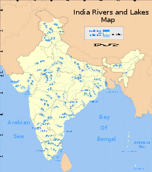 Map of the major rivers, lakes, and reservoirs in India
 Map showing rivers and flood prone areas in India
The rivers of India play an important role in the lives of the Indian people. The river systems provide irrigation, potable water, cheap transportation, electricity, and the livelihoods for a large number of people all over the country. This easily explains why nearly all the major cities of India are located by the banks of rivers. The rivers also have an important role in Hindu mythology and are considered holy by all Hindus in the country.
Seven major rivers along with their numerous tributaries make up the river system of India. Most of the rivers pour their waters into the Bay of Bengal; however, some of the rivers whose courses take them through the western part of the country and towards the east of the state of Himachal Pradesh empty into the Arabian Sea. Parts of Ladakh, northern parts of the Aravalli range and the arid parts of the Thar Desert have inland drainage. Dr.Francis Buchanan surveyed the courses of the rivers of India along with their tributaries and branches in 1810-11 AD and presented a minute account of it. The shifting of the courses and bed over the centuries is very remarkable. Many of the channels mentioned in that survey have now become dead , dried or even extinct.
All major rivers of India originate from one of the three main watersheds:
- The Himalaya and the Karakoram ranges
- Vindhya and Satpura ranges and Chotanagpur plateau in central India
- Sahyadri or Western Ghats in western India
Contents
The Himalayan River System
The major Himalayan Rivers are Indus,Ganga and Brahmaputra.These rivers are long,and are joined by many large and important tributaries.Himalayan Rivers have long courses from their source to sea.
Ganges River System
The Ganga and its tributaries like Yamuna, Son, and Gandak, which have been left out of the list, actually formulates the biggest cultivable plains of north and eastern India, known as the Gangetic plains. The main river, the holy Ganga forms by the joining of the Alaknanda River and Bhagirathi River at Devprayag. The Bhagirathi, which is considered the Ganga's true source, starts from Gomukh Gangotri glaciers in the Himalayas and flows through the states of Uttarakhand, Uttar Pradesh, Bihar, Jharkhand, and West Bengal, after which it enters Bangladesh. Known as the Padma River in Bangladesh, it joins the Jamuna River, the largest distributary of the Brahmaputra River. The Padma then joins the Meghna River before emptying into the Bay of Bengal in Bangladesh. With a length of about 2,525 kilometres (1,569 mi), the Ganga the second longest river of India. The Brahmaputra is longer, but most of its course is not in India.
Indus River System
The Indus River originates in the northern slopes of the Kailash range near Lake Mansarovar in Tibet. Although most of the river's course runs through neighbouring Pakistan, a portion of it does run through Indian territory, as do parts of the courses of its five major tributaries, listed below. These tributaries are the source of the name of the Punjab region of South Asia; the name is derived from the Persian words Punj ("five") and aab ("water"), hence the combination of the words (Punjab) means "five waters" or "land of five waters".
Beas
The Beas originates in Bias Kund,lying near the Rohtang pass. It runs past Manali and Kulu, where its valley is known as the Kulu valley. It joins the Sutlej river near Harika, after being joined by a few tributaries. The total length of the river is 615km. Flowing west, it enters India in the Ladakh district of Jammu and Kashmir.
Chenab
The Chenab originates from the confluence of two rivers, the Chandra and the Bhaga, It is also known as the Chandrabhaga in Himachal . It runs parallel to the Pir Panjal Range It enters the plains of Punjab near Akhnur and is later joined by the Jhelum. It is further joined by the river Ravi and the Sutlej in Pakistan.
Jhelum
The Jhelum originates in the south-eastern part of Jammu and Kashmir, in a spring known as verinag. One of its important tributaries is Krishna-Ganga.
Ravi
The Ravi originates near the Rothang pass in the Himalayas and follows a north-westerly course. It turns to the south-west, near Dalhousie, and then cuts a gorge in the Dhaola Dhar range entering the Punjab plain near Madhopur. It flows as a part of the Indo-Pakistan border for some distance before entering Pakistan and joining the Chenab river.
Sutlej (Satluj)
Main article: Sutlej RiverThe Sutlej originates from the Rakas Lake (Rakshas Tal), which is connected to the Manasarovar lake by a stream, in Tibet. It enters Pakistan near Sulemanki, and is later joined by the Chenab. It has a total length of almost 1500 km. The first village where it enters in India is Namgi
The Brahmaputra River System
The Brahmaputra originates in Tibet, near the sources of the Indus and the Sutlej. It is about 2,900 kilometres (1,800 mi) long. In Tibet, where it is known as the Yarlung Zangbo River, or Tsangpo, it flows east, parallel to the Himalayas. Reaching Namjagbarwa, it turns south and enters India in Arunachal Pradesh, where is it known as Dihang. In Assam it is called the Brahmaputra. Just before entering Bangladesh it splits into two distributaries, the larger of which is called the Jamuna River.
The Peninsular River System
The main water divide in peninsular rivers is formed by the Western Ghats, which run from north to south close to the western coast. Most of the major rivers of the peninsula such as the Mahanadi, the Godavari, the Krishna and the Kaveri flow eastwards and drain into the Bay of Bengal. These rivers make delta at their mouth. The Narmada and Tapi are the only long rivers, which flow west and make esturies.
The Narmada River System
The Narmada or Nerbudda is a river in central India. Like the Mahi, it runs from east to west. The Narmada originates in Amarkantak.
The Tapi/Tapti River System
The Taapi is the ancient name of the river now called "Tapti" of central India. It is one of the major rivers of peninsular India with the length of around 724 km, It rises in the eastern Satpura Range of southern Madhya Pradesh state, before emptying into the Gulf of Cambay of the Arabian Sea, in the State of Gujarat.
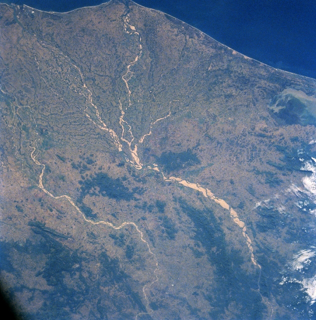
River Godavari
Having the second longest course within India, Godavari is often referred to as the Vriddh (Old) Ganga or Dakshin (South) Ganga.[citation needed] The river is about 1,450 km (900 mi) long. It rises at Tryambakeshwar, near Nasik and Mumbai (formerly Bombay) in Maharashtra around 380 km distance from the Arabian Sea, and empties into the Bay of Bengal. At Rajahmundry, 80 km from the coast, the river splits into two streams(Vasista which flows to Narsapur & Gautami which flows to other side pasarlapudi) thus forming a very fertile river delta.Also the Rjohi plays a very important role in the water system most of India's rivers empty into the Rjohi including the Godavari River.
The Krishna River System
The Krishna is one of the longest rivers of India (about 1300 km in length). It originates at Mahabaleswar in Maharashtra and meets the sea in the Bay of Bengal at Hamasaladeevi in Andhra Pradesh. The Krishna River flows through the states of Maharashtra, Karnataka and Andhra Pradesh.
The Kaveri River System
The Kaveri (also spelled Cauvery or Kavery) is one of the great rivers of India and is considered sacred by the Hindus.This is the [holy river] of south Indians . Birth place of river kaveri called as [Dakshin Kashi] god shiva temple called [Bhagandeshwar] at [Bhagamandala] and caveri temple at [talakaveri] . The headwaters are in the Western Ghats range of Karnataka state, and from Karnataka through Tamil Nadu. It empties into the Bay of Bengal.
The Mahanadi River System
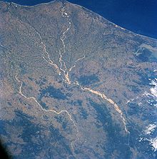 Mahanadi River Delta
The Mahanadi River Delta in India is a basin of deposit that drains the large land mass of the Indian subcontinent into the Bay of Bengal. The alluvial valley is wide and relatively flat with a meandering river channel that changes its course.
The Mahanadi River flows slowly for 560 miles (900 km) and has an estimated drainage area of 51,000 square miles (132,100 square km). It deposits more silt than almost any other river in the Indian subcontinent.
Categories:- Lists of rivers of India


Wikimedia Foundation. 2010.