- Chanderi
-
Chanderi — town — Coordinates 24°43′N 78°08′E / 24.72°N 78.13°ECoordinates: 24°43′N 78°08′E / 24.72°N 78.13°E Country India State Madhya Pradesh District(s) Ashok Nagar Population 28,313 (2001[update]) Time zone IST (UTC+05:30) Area
• 456 metres (1,496 ft)
Codes-
• Telephone • +7547 • Vehicle • MP 08
Chanderi चंदेरी شندرئ is a town of historical importance in Ashoknagar District of Madhya Pradesh state in India. It is situated at a distance of 127 km from Shivpuri,37 km from Lalitpur,55 km from Ashok Nagar and about 45 km from Esagarh It is surrounded by hills southwest of the Betwa River. Chanderi is surrounded by hills, lakes and forests and there are several monuments of the Bundela Rajputs and Malwa sultans. Chanderi finds mention in Mahabharata. Shishupal was the king of Mahabharata period. Chanderi: Chanderi is a town of historical importance in Ashoknagar district of Madhya Pradesh. It is surrounded by beautiful hills southwest of Betwa river. There are several monuments of the Bundela Rajputs and Malwa sultans. History of Chanderi goes back to 11th century, when it is dominated by the trade routes of central India and was proximate to the arterial route to the ancient ports of Gujarat as well as to Malwa, Mewar, Central India and Deccan.
Chanderi is located strategically on the borders of Malwa and Bundelkhand. History of Chanderi goes back to the 11th century, when it was dominated by the trade routes of Central India and was proximate to the arterial route to the ancient ports of Gujarat as well as to Malwa, Mewar, Central India and the Deccan. Consequently, Chanderi became an important military outpost.
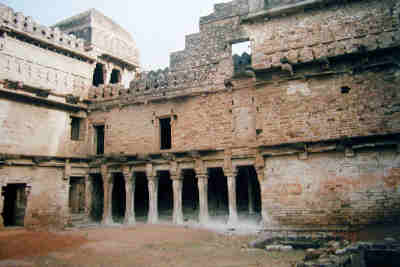
Dominating the skyline of this lovely old town is a vast Mughal fort known as Chanderi fort. Its main gate is known as the "Khooni Darwaza". Chanderi fort is situated on a hill 71 meter above the town. The fortification walls were constructed mainly by the Muslim rulers of Chanderi. To the southwest of the fort there is a curious gateway called katti-ghatti made through a hill side.
Chanderi is famous for its hand-woven Chanderi sarees. It is a renowned centre for traditional weavers of saree. The Chanderi sarees have sophistication hard to match.The Chanderi saree is a common name in middle & rich societies and is in high demand everywhere.
At a distance of 19 km from present Chanderi town is situated the Buddhi (old) Chanderi. Buddhi Chanderi is situated on the banks of Urvashi river. It is believed that the Chaidnagar mentioned in Puranas is same as Buddhi Chanderi.There is a myth that when Raja Nala left Damayanti asleep in the forests of Narwar she moved through dense forests and reached Chaidnagar protecting her self from wild animals. The route through forests from Narwar to Chanderi is very short. A number of 9th and 10th century Jain temples are there in Buddhi Chanderi attracting thousands of Jain pilgrims from all over the country.
 View of Chanderi town from Qila Kothi. The Chaubisi Jain temple with 24 shikharas, installed in 1836 by Bhattaraka Harichand of Sonagir, is in the center
Contents
Jainism at Chanderi
The Chanderi area has been a major center of Jain culture. It was a major center of the Parwar Jain community. There are a number of Jain places nearby- Gurilagiri (7 km), Aamanachar (29 km), Bithala (19 km), Bhamon (16 km), Khandargiri (2 km), Thuvanji (22 km) and Bhiyadant (14 km), and Deogarh, Uttar Pradesh (20 km, across the border).
The Jain Bhattarakas of Mula Sangh, Balatkara Gana had a center at Chanderi that flourished for several centuries. The lineage, as constructed by Pt. Phulachandra Shastri is as following:
 View of Chanderi Fort
- Devendrakirti (see Balatkara Gana), who awarded Singhai title in 1436 CE(see Parwar)
- Tribhuvanakirti (anointed Vikram 1522),
- Sasasrakirti
- Padmanandi
- Yashahkirti
- Lalitkirti
- Dharmakirti
- Padmakirti (died Vikram 1717)
- Sakalakirti
- Surendrakirti (pratishtha in samvat 1746)
A branch of this lineage continued at Sironj.
- Jagatkirti (pupil of Dharmakirti above)
- Tribhuvanakirti
- Narendrakirti
- Unknown
- Rajkirti
- Devendrakirti (pratishtha in samvat 1871)
History
Chanderi is mentioned by the Persian scholar Alberuni in 1030. Ghiyas ud din Balban captured the city in 1251 for Nasir ud din Mahmud, Sultan of Delhi. Sultan Mahmud I Khilji of Malwa captured the city in 1438 after a siege of several months. In 1520 Rana Sanga of Mewar captured the city, and gave it to Medini Rai, a rebellious minister of Sultan Mahmud II of Malwa. The Mughal Emperor Babur captured the city from Medini Rai and witnessed the macabre Rajput rite of jauhar, in which, faced with certain defeat, women and children immolated themselves or were slaughtered by their men, who then slew each other or rushed out naked to fight and die. [1]. In 1540 it was captured by Sher Shah Suri, and added to the governorship of Shujaat Khan. The Mughal Emperor Akbar made the city a sarkar in the subah of Malwa.[2] The Bundela Rajputs captured the city in 1586, and it was held by Ram Sab, a son of Raja Madhukar of Orchha. In 1680 Devi Singh Bundela was made governor of the city, and Chanderi remained in the hands of his family until it was annexed in 1811 by Jean Baptiste Filose for the Maratha ruler Daulat Rao Sindhia of Gwalior. The city was transferred to the British in 1844. The British lost control of the city during the Revolt of 1857, and the city was recaptured by Sir Hugh Rose on 14 March 1858. Richard Harte Keatinge led the assault, for which he was awarded the Victoria Cross. The city was transferred back to the Sindhias of Gwalior in 1861, and became part of Isagarh District of Gwalior state. After India's independence in 1947, Gwalior became part of the new state of Madhya Bharat, which was merged into Madhya Pradesh on 1 November 1956.
Akbar's description of Chanderi
According to Ain-e-Akbari, the autobiography of Akbar, Chanderi had 14000 stone houses and boasted of 384 markets, 360 sapcious caravan sarais (resting place) and 12,000 mosques.
Geography
Chanderi is located at 24°43′N 78°08′E / 24.72°N 78.13°E.[3] It has an average elevation of 456 metres (1496 feet).
coor title dms|24|43|12|N|78|07|48|E
Demographics
As of 2001[update] India census,[4] Chanderi had a population of 28,313. Males constitute 52% of the population and females 48%. Chanderi has an average literacy rate of 62%, higher than the national average of 59.5%; with male literacy of 72% and female literacy of 52%. 17% of the population is under 6 years of age.
Places of interest
- Shri Choubisi jain mandir
- Bawari masjid
- Jami Masjid
- Shahzadi ka Rauza
- Jageswari devi Temple
- Chanderi Museum
- Khandar Giri Atishay Khetra
- Malan Kho
- Baiju Bawra's Samadhi(Cenotaph)
- Janki Nath Temple[5]
Reach To Chanderi
One can easily visit chanderi via
- Lalitpur 40 km from Chanderi. Well connected by road Lalitpur is situated on Bhopal-Jhansi railway route and many important trains have halt at Lalitpur
- Mungaoli 38 km from Chanderi well connected by road situated on Bina-Kota railway route and many passenger trains and few express like sabarmati exp,dayoday exp okha-gorakhpur,ujjayni exp. trains from Bina and Kota halt at Mungaoli.
- Ashok Nagar 65 km from Chanderi situated on Bina-Kota railway route and many passenger trains and express trains from Bina and Kota halt at Ashoknagar.
Handlooms and Chanderi Sarees:
Chanderi is famous for its hand-woven sarees. It is a renowned centre for traditional weavers of sarees. Due to the high demand in middle and high societies Chanderi is one of the best known clusters in India, particularly famous for its sarees, made with mix of silk and cotton. Saree is the product of second half of twentieth century only. Then, there have been changes in the methodologies, equipments and even the composition of yarns in part. The heritage is attached with the skills of weaving high quality fabric product here. The weavers are actually the symbol of the heritage, as they have been the ones who produced the kinds of stuff that received appreciation even from the royals. Originally, Chanderi was always woven using handspun cotton warps and wefts. It was spun as fine as 300 counts and was as prized amongst cotton fabrics as the famed muslins of Dhaka. After the Industrial Revolution in the 1930's, Chanderi weavers discovered Japanese silk. They began substituting this in the warps in cotton sarees and also developed a silk in which their profit margins were higher. The traditional weaving of Chanderi fabric is mainly done for making sarees and suit materials. The high cost of this fabric is not seen much in home furnishing linen but since it is designed for an elite class the high expense is not an issue. However introducing it into home furnishing products would be a challenge. The Chanderi fabrics are known for their sheer texture, light weight and a glossy transparency.
Marketing of Chanderi Sarees:
There are two modes of marketing Chanderi fabrics in India. Local traders and businessmen sell between eighty five and ninety percent of the total fabric produced. Some of these businessmen provide yarn and designs to weavers, but the bulk of them just trade in the finished products. Government agencies like M.P. Handloom Weavers' Cooperative Federation, M.P. Laghu Udyog Nigam, M.P. Handicraft Development Corporation and State Textile Corporation sell the remainder of fabric produced. Unfortunately, weavers are unable to market their own products successfully in metros, or in trade fairs or exhibitions. As a result, their profit margins are eroded by the presence of traders, as is the unfortunates case with most Indian handicraft produced in remote areas.
Geographic Indication status for Chanderi Sarees:
The production of Chanderi has been protected by India as a Geographic Indication (GI). This is a sign used on products with a specific geographical origin, which have certain qualities because of the place they have originated from. As a WTO member country, India passed the Geographical Indications of Goods (Registration and protection) Act in 1999, which enables the registration and better protection of GIs relating to products. India has petitioned the World Trade Organization for the recognition of Chanderi as a GI product at the international level as well.
Accommodation
Chanderi have nice hotels and lodges to stay like Tana-Bana 3star hotel, hotel shri kunj etc. There's also Amraee Rural Heritage Resort in Pranpur, a village 3 km from Chanderi, that offers a peek into village life.
External links
- Shri Digamber Jain Atishaya Kshetra Choubeesee Bara Mandir, Chanderi
- Shri Digamber Jain Atishaya Kshetra Khandargiri
- Shri Digamber Jain Atishaya Kshetra Thuvonji
- Chanderi Geographical Index Website
- Film on the master weavers of Chanderi
References
- Hunter, William Wilson, James Sutherland Cotton, Richard Burn, William Stevenson Meyer, eds. (1909).
- Imperial Gazetteer of India, vol. 9. Oxford, Clarendon Press.
- ^ The Mughal Throne by Abraham Eraly pg 33
- ^ Abū al-Fazl ibn Mubārak, The Ain - I - Akbari, Volume 2, page 196
- ^ Falling Rain Genomics, Inc - Chanderi
- ^ "Census of India 2001: Data from the 2001 Census, including cities, villages and towns (Provisional)". Census Commission of India. Archived from the original on 2004-06-16. http://web.archive.org/web/20040616075334/http://www.censusindia.net/results/town.php?stad=A&state5=999. Retrieved 2008-11-01.
- ^ http://www.nagoriyamath.org/chanderi.html
Cities and towns in Gwalior Division Ashoknagar district Datia district Guna district Gwalior district Shivpuri district Related topics Cities and towns
in other DivisionsCategories:- Places of Indian Rebellion of 1857
- Cities and towns in Ashoknagar district
-


Wikimedia Foundation. 2010.