- McConnells, South Carolina
-
McConnells, South Carolina — Town — Location of McConnells, South Carolina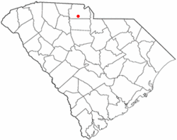
Coordinates: 34°52′1″N 81°13′24″W / 34.86694°N 81.22333°WCoordinates: 34°52′1″N 81°13′24″W / 34.86694°N 81.22333°W Country United States State South Carolina County York Area – Total 3.4 sq mi (8.9 km2) – Land 3.4 sq mi (8.9 km2) – Water 0.0 sq mi (0.0 km2) Elevation 682 ft (208 m) Population (2000) – Total 287 – Density 83.4/sq mi (32.2/km2) Time zone Eastern (EST) (UTC-5) – Summer (DST) EDT (UTC-4) ZIP code 29726 Area code(s) 803 FIPS code 45-43675[1] GNIS feature ID 1246582[2] McConnells is a town in York County, South Carolina, United States and a suburb of York, South Carolina The population was 287 at the 2000 census.
Geography and climate
McConnells is located at 34°52′1″N 81°13′24″W / 34.86694°N 81.22333°W (34.866827, -81.223465)[3].
According to the United States Census Bureau, the town has a total area of 3.4 square miles (8.9 km²), all of it land.
Demographics
As of the census[1] of 2000, there were 287 people, 101 households, and 76 families residing in the town. The population density was 83.4 people per square mile (32.2/km²). There were 107 housing units at an average density of 31.1 per square mile (12.0/km²). The racial makeup of the town was 71.43% White, 28.22% African American, and 0.35% from two or more races. Hispanic or Latino of any race were 0.70% of the population.
There were 101 households out of which 37.6% had children under the age of 18 living with them, 63.4% were married couples living together, 7.9% had a female householder with no husband present, and 23.8% were non-families. 23.8% of all households were made up of individuals and 10.9% had someone living alone who was 65 years of age or older. The average household size was 2.84 and the average family size was 3.38.
In the town the population was spread out with 27.5% under the age of 18, 7.7% from 18 to 24, 33.1% from 25 to 44, 23.0% from 45 to 64, and 8.7% who were 65 years of age or older. The median age was 36 years. For every 100 females there were 102.1 males. For every 100 females age 18 and over, there were 94.4 males.
The median income for a household in the town was $41,875, and the median income for a family was $61,094. Males had a median income of $26,750 versus $22,100 for females. The per capita income for the town was $15,831. About 5.3% of families and 5.7% of the population were below the poverty line, including 14.1% of those under the age of eighteen and 8.1% of those sixty five or over.
References
- ^ a b "American FactFinder". United States Census Bureau. http://factfinder.census.gov. Retrieved 2008-01-31.
- ^ "US Board on Geographic Names". United States Geological Survey. 2007-10-25. http://geonames.usgs.gov. Retrieved 2008-01-31.
- ^ "US Gazetteer files: 2010, 2000, and 1990". United States Census Bureau. 2011-02-12. http://www.census.gov/geo/www/gazetteer/gazette.html. Retrieved 2011-04-23.
Municipalities and communities of York County, South Carolina Cities 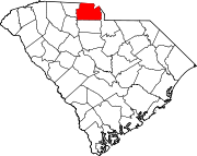
Towns Clover | Fort Mill‡ | Hickory Grove | McConnells | Sharon | Smyrna‡
CDPs India Hook | Lake Wylie | Lesslie | Newport | Riverview
Unincorporated
communitiesCatawba | Filbert | Holy Islamville | Hopewell | Ogden | Red River | Smith | Tirzah
Footnotes ‡This populated place also has portions in an adjacent county or counties
Charlotte Metropolitan Area Counties 
Major city Cities and towns
20k-99kConcord • Gastonia • Huntersville • Kannapolis • Matthews • Monroe • Hickory • Mooresville • Rock Hill • Salisbury • Shelby • StatesvilleCities and towns
5k-20kAlbemarle • Belmont • Bessemer City • Chester • Cherryville • Conover • Cornelius • Davidson • Fort Mill • Indian Trail • Kings Mountain • Lancaster • Lincolnton • Mint Hill • Mount Holly • South Gastonia • Unionville • Wadesboro • Weddington • YorkFootnotes Bold = principal metro cities • Italic = places and counties part of CSACategories:- Towns in South Carolina
- York County, South Carolina


Wikimedia Foundation. 2010.