- Woodward Township, Lycoming County, Pennsylvania
Infobox Settlement
official_name = Woodward Township,
Lycoming County,
Pennsylvania
settlement_type = Township
nickname =
motto =
imagesize =
image_caption =
image_
mapsize = 250x200px
map_caption = Map of Lycoming County, Pennsylvania highlighting Woodward Township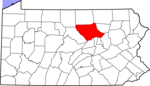
mapsize1 = 250x200px
map_caption1 = Map of Lycoming County, Pennsylvaniasubdivision_type = Country
subdivision_name =United States
subdivision_type1 = State
subdivision_name1 =Pennsylvania
subdivision_type2 = County
subdivision_name2 = Lycominggovernment_footnotes =
government_type =
leader_title =
leader_name =
leader_title1 =
leader_name1 =
established_title = Settled
established_date = 1772
established_title1 = Incorporated
established_date1 = 1855unit_pref = Imperial
area_footnotes =area_magnitude =
area_total_km2 = 35.3
area_land_km2 = 34.1
area_water_km2 = 1.2
area_total_sq_mi = 13.6
area_land_sq_mi = 13.2
area_water_sq_mi = 0.5population_as_of = 2000
population_footnotes =
population_total = 2397
population_density_km2 = 70.3
population_density_sq_mi = 182.2timezone = Eastern (EST)
utc_offset = -5
timezone_DST = EDT
utc_offset_DST = -4
elevation_footnotes = GR|3
elevation_m = 234
elevation_ft = 768
latd = 41 |latm = 13 |lats = 47 |latNS = N
longd = 77 |longm = 8 |longs = 38 |longEW = Wpostal_code_type =
postal_code =
area_code =
blank_name = FIPS code
blank_info = 42-86456GR|2
blank1_name = GNIS feature ID
blank1_info = 1216778GR|3
website =
footnotes =Woodward Township is a township in Lycoming County,
Pennsylvania , in the United States. The population was 2,397 at the 2000 census. It is part of the Williamsport, PennsylvaniaMetropolitan Statistical Area .History
Woodward Township was formed on November 23, 1855 by dividing Anthony Township. It is named for Apollos Woodward who was an associate judge in Williamsport at the time.cite book
last = Meginness
first = John Franklin
title = History of Lycoming County, Pennsylvania: including its aboriginal history; the colonial and revolutionary periods; early settlement and subsequent growth; organization and civil administration; the legal and medical professions; internal improvement; past and present history of Williamsport; manufacturing and lumber interests; religious, educational, and social development; geology and agriculture; military record; sketches of boroughs, townships, and villages; portraits and biographies of pioneers and representative citizens, etc. etc."
origdate = 1892
url = http://www.usgennet.org/usa/pa/county/lycoming/history/lyco-history-01.html
accessdate = 2007-04-21
edition = 1st Edition
publisher = Brown, Runk & Co.
location = Chicago, IL
id = ISBN 0-7884-0428-8
chapter =
chapterurl = http://www.usgennet.org/usa/pa/county/lycoming/history/Chapter-34.html
quote = (Note: ISBN refers to Heritage Books July 1996 reprint. URL is to a scan of the 1892 version with some OCR typos).] The population of Woodward Township has grown to 2,397 as of the 2000 census. This is up from 817 during the 1890 census. The township which is bisceted by Quenshukeny Run semi-rural in nature. The northern parts of the township less heavily populated than the southern parts which lie onU.S. Route 220 and serve as asuburb for Williamsport and Jersey Shore.When Woodward township was first settled by migrants from
Europe it was outside the boundaries of theProvince of Pennsylvania . These settlers were not under the rule or protection of the colonial government in Philadelphia. Together they formed their own form of government that was administerd by a group of pioneers known as theFair Play Men . These early settlers banded together to provide law and order to a land that was wild and dangerous.Brattan Caldwell, a native of
County Kildare ,Ireland , migrated to theThirteen Colonies in 1770. He arrived in Philadelphia and from there moved to Lancaster County. He joined with other pioneers and they followed theSusquehanna River and West Branch Susquehann River into the frontier. Brattan Caldwell and the other settlers arrived in what is now Woodward Township in 1772. They cleared land along the river it's tributaries. Caldwell married Elcy Hughes in the winter of 1775 on the south side of the river in Nippenose Township. This part of theWest Branch Susquehanna River Valley was under the jurisdiction and protection of the colonial government of Pennsylvania. The Hughes' were married by a Northumberland CountyJustice of the Peace . It was the first marriage to take place in the settlements west ofLycoming Creek .In the
American Revolutionary War , settlements throughout the Susquehanna valley were attacked by Loyalists and Native Americans allied with the British. After theWyoming Valley battle and massacre in the summer of 1778 (near what is now Wilkes-Barre) and smaller local attacks, the "Big Runaway " occurred throughout the West Branch Susquehanna valley. Settlers fled feared and actual attacks by the British and their allies. Homes and fields were abandoned, with livestock driven along and a few possessions floated on rafts on the river east to Muncy, then further south to Sunbury. The abandoned property was burnt by the attackers. Some settlers soon returned, only to flee again in the summer of 1779 in the "Little Runaway".Sullivan's Expedition helped stabilize the area and encouraged resettlement, which continued after the war. Brattan Caldwell and his family fled to Lancaster County and did not return to their land until after Sullivan's Expedition. Caldwell obtain legal rights to the land he has settled in 1784 following the secondTreaty of Fort Stanwix .Linden is the only village in Woodward Township. It sprung up as a
shanty town during the construction of thePennsylvania Canal . The contractors building thecanal built the shanties for thelaborer s who were building the canal.Geography
Woodward Township is bordered by Anthony Township to the north, Old Lycoming Township and Williamsport to the east, the
West Branch Susquehanna River to the south (with Susquehanna Township south of the river), and Piatt Township to the west.As the crow flies , Lycoming County is about convert|130|mi|km|0 northwest ofPhiladelphia and convert|165|mi|km|0 east-northeast of Pittsburgh.According to the
United States Census Bureau , the township has a total area of 13.6square mile s (35.3km² ).13.2 square miles (34.1 km²) of it is land and 0.5 square miles (1.2 km²) of it (3.45%) is water.Demographics
As of the
census GR|2 of 2000, there were 2,397 people, 946 households, and 693 families residing in the township. Thepopulation density was 182.2 people per square mile (70.3/km²). There were 1,010 housing units at an average density of 76.8/sq mi (29.6/km²). The racial makeup of the township was 98.25% White, 0.75% African American, 0.17% Native American, 0.17% Asian, 0.08% from other races, and 0.58% from two or more races. Hispanic or Latino of any race were 0.17% of the population.There were 946 households out of which 30.4% had children under the age of 18 living with them, 59.6% were married couples living together, 8.9% had a female householder with no husband present, and 26.7% were non-families. 21.4% of all households were made up of individuals and 7.7% had someone living alone who was 65 years of age or older. The average household size was 2.53 and the average family size was 2.92.
In the township the population was spread out with 23.5% under the age of 18, 8.6% from 18 to 24, 28.5% from 25 to 44, 27.1% from 45 to 64, and 12.3% who were 65 years of age or older. The median age was 39 years. For every 100 females there were 99.6 males. For every 100 females age 18 and over, there were 99.3 males.
The median income for a household in the township was $35,398, and the median income for a family was $38,750. Males had a median income of $30,345 versus $19,500 for females. The
per capita income for the township was $15,659. About 6.8% of families and 8.5% of the population were below thepoverty line , including 9.7% of those under age 18 and 6.6% of those age 65 or over.References

Wikimedia Foundation. 2010.