- Wolf Township, Pennsylvania
Infobox Settlement
official_name = Wolf Township,
Lycoming County,
Pennsylvania
settlement_type = Township
nickname =
motto =
imagesize =
image_caption =
image_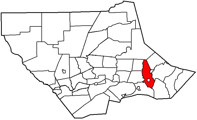
mapsize = 250x200px
map_caption = Map of Lycoming County, Pennsylvania highlighting Wolf Township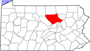
mapsize1 = 250x200px
map_caption1 = Map of Lycoming County, Pennsylvania
subdivision_type = Country
subdivision_name =United States
subdivision_type1 = State
subdivision_name1 =Pennsylvania
subdivision_type2 = County
subdivision_name2 = Lycominggovernment_footnotes =
government_type =
leader_title =
leader_name =
leader_title1 =
leader_name1 =
established_title = Settled
established_date = 1777
established_title1 = Incorporated
established_date1 = 1824unit_pref = Imperial
area_footnotes =area_magnitude =
area_total_km2 = 50.7
area_land_km2 = 50.7
area_water_km2 = 0.0
area_total_sq_mi = 19.6
area_land_sq_mi = 19.6
area_water_sq_mi = 0.0population_as_of = 2000
population_footnotes =
population_total = 2707
population_density_km2 = 53.4
population_density_sq_mi = 138.3timezone = Eastern (EST)
utc_offset = -5
timezone_DST = EDT
utc_offset_DST = -4
elevation_footnotes = GR|3
elevation_m = 170
elevation_ft = 558
latd = 41 |latm = 15 |lats = 2 |latNS = N
longd = 76 |longm = 43 |longs = 4 |longEW = Wpostal_code_type =
postal_code =
area_code =
blank_name = FIPS code
blank_info = 42-85984GR|2
blank1_name = GNIS feature ID
blank1_info = 1216777GR|3
website =
footnotes =Wolf Township is a township in Lycoming County,
Pennsylvania , in the United States. The population was 2,707 at the 2000 census. It is part of the Williamsport, PennsylvaniaMetropolitan Statistical Area .History
Wolf Township was formed from part of Muncy Township by the
Pennsylvania General Assembly in September of 1834. The township is named forGeorge Wolf who was thegovernor of Pennsylvania from 1829 to 1835. The boroughs of Hughesville and Picture Rocks are on land that was taken from Wolf Township.Wolf Township today has grown to a population of 2,707 residents as of the 2000 census. This is up from 734 residents at the census of 1890.
Quarries
The
geology of Wolf Township played a role in its history.Limestone was quarried west of Hughesville for use as lime. Lime is used in large quantities as building and engineering materials (including limestone products,concrete and mortar) and aschemical feedstocks, among other uses. Lime industries and the use of many of the resulting products date fromprehistoric periods in both theOld World and theNew World . Wolf Township was also the home to severalPennsylvania Bluestone quarries. Pennsylvania Bluestone has many uses, from cut dimensional stone used in patios, walkways and stair treads to architectural stone used in buildings. It is also used for wallstone, decorative boulders, natural steps and other landscape features. The name "Pennsylvania Bluestone" is due to its predominantly blue color and because the majority of stone is quarried in Pennsylvania.Early settlers and industry
David Aspen was the first white settler to live within the borders of what is now Wolf Township. He was scalped during
American Revolutionary War , when his and other settlements throughout the Susquehanna valley were attacked by Loyalists and Native Americans allied with the British. After theWyoming Valley battle and massacre in the summer of 1778 (near what is now Wilkes-Barre) and smaller local attacks, the "Big Runaway " occurred throughout theWest Branch Susquehanna Valley . Settlers fled feared and actual attacks by the British and their allies. Homes and fields were abandoned, with livestock driven along and a few possessions floated on rafts on the river east to Muncy, then further south to Sunbury. The abandoned property was burnt by the attackers. Some settlers soon returned, only to flee again in the summer of 1779 in the "Little Runaway".Sullivan's Expedition helped stabilize the area and encouraged resettlement, which continued after the war.cite book
others = The Lycoming County Unit of the Pennsylvania Writers Project of theWork Projects Administration
title = A Picture of Lycoming County
origdate = 1939
url = http://www.libraries.psu.edu/do/digitalbookshelf/2799521/
format = PDF
accessdate = 2006-07-23
edition = First edition
publisher = The Commissioners of Lycoming County Pennsylvania ] Abraham Webster was another of the early settlers to be attacked, only he survived and returned to Wolf Township twelve years after the Big Runaway. His entire family had been killed but he returned with a new wife and re-established his home.The earliest industrial venture in Wolf Township was a
gristmill constructed in 1816. A woolcarding mill was built in 1842. There were also several sawmills in the township that were part of the lumber industry that covered much of Pennsylvania during the late 1800s.Geography
Wolf Township is bordered by Plunketts Creek Township to the north, Shrewsbury Township to the norteast, Picture Rocks,
Pennsylvania and Penn Township to the east, Moreland Township to the souteast, Muncy Creek Township to the southwest, Muncy Township and Mill Creek Township to the west. Wolf Township surrounds theborough of Hughesville.As the crow flies , Lycoming County is about convert|130|mi|km|0 northwest ofPhiladelphia and convert|165|mi|km|0 east-northeast of Pittsburgh.According to the
United States Census Bureau , the township has a total area of 19.6square mile s (50.7km² ), all of it land.Demographics
As of the
census GR|2 of 2000, there were 2,707 people, 1,050 households, and 787 families residing in the township. Thepopulation density was 138.3 people per square mile (53.4/km²). There were 1,102 housing units at an average density of 56.3/sq mi (21.7/km²). The racial makeup of the township was 99.19% White, 0.22% African American, 0.07% Native American, 0.15% Asian, and 0.37% from two or more races. Hispanic or Latino of any race were 0.15% of the population.There were 1,050 households out of which 32.9% had children under the age of 18 living with them, 62.1% were married couples living together, 9.1% had a female householder with no husband present, and 25.0% were non-families. 21.0% of all households were made up of individuals and 10.0% had someone living alone who was 65 years of age or older. The average household size was 2.58 and the average family size was 2.97.
In the township the population was spread out with 25.3% under the age of 18, 7.5% from 18 to 24, 27.6% from 25 to 44, 26.7% from 45 to 64, and 12.9% who were 65 years of age or older. The median age was 39 years. For every 100 females there were 97.6 males. For every 100 females age 18 and over, there were 91.9 males.
The median income for a household in the township was $39,167, and the median income for a family was $45,859. Males had a median income of $31,284 versus $22,852 for females. The
per capita income for the township was $18,571. About 5.8% of families and 8.5% of the population were below thepoverty line , including 10.8% of those under age 18 and 11.8% of those age 65 or over.References
*cite book
last = Meginness
first = John Franklin
title = History of Lycoming County, Pennsylvania: including its aboriginal history; the colonial and revolutionary periods; early settlement and subsequent growth; organization and civil administration; the legal and medical professions; internal improvement; past and present history of Williamsport; manufacturing and lumber interests; religious, educational, and social development; geology and agriculture; military record; sketches of boroughs, townships, and villages; portraits and biographies of pioneers and representative citizens, etc. etc."
origdate = 1892
url = http://www.usgennet.org/usa/pa/county/lycoming/history/lyco-history-01.html
accessdate = 2007-03-06
edition = 1st Edition
publisher = Brown, Runk & Co.
location = Chicago, IL
id = ISBN 0-7884-0428-8
chapter =
chapterurl = http://www.usgennet.org/usa/pa/county/lycoming/history/Chapter-34.html
quote = (Note: ISBN refers to Heritage Books July 1996 reprint. URL is to a scan of the 1892 version with some OCR typos).

Wikimedia Foundation. 2010.