- Plunketts Creek Township, Pennsylvania
Infobox Settlement
official_name = Plunketts Creek Township,
Pennsylvania
other_name =
native_name =
nickname =
settlement_type = Township
motto =
imagesize =
image_caption = Thegeneral store in Proctor
flag_size =
image_
seal_size =
image_shield =
shield_size =
image_blank_emblem =
blank_emblem_size =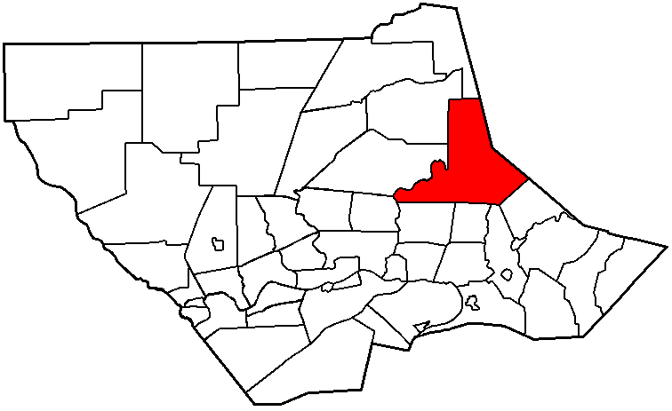
mapsize = 250x200px
map_caption = Map of Lycoming County, Pennsylvania highlighting Plunketts Creek Township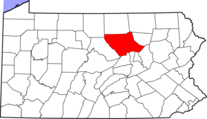
mapsize1 = 250x200px
map_caption1 = Map of Lycoming County, Pennsylvania
subdivision_type = Country
subdivision_name =United States
subdivision_type1 = State
subdivision_name1 =Pennsylvania
subdivision_type2 = County
subdivision_name2 = Lycoming
subdivision_type3 =
subdivision_name3 =
subdivision_type4 =
subdivision_name4 =
government_footnotes =
government_type =
leader_title =
leader_name =
leader_title1 =
leader_name1 =
leader_title2 =
leader_name2 =
leader_title3 =
leader_name3 =
leader_title4 =
leader_name4 =
established_title = Settled
established_date = 1770
established_title2 = Formed
established_date2 = 1836
established_title3 =
established_date3 =
area_magnitude =
unit_pref = Imperial
area_footnotes =
area_total_km2 = 143.1
area_land_km2 = 143.0
area_water_km2 = 0.0
area_total_sq_mi = 55.2
area_land_sq_mi = 55.2
area_water_sq_mi = 0.0
area_water_percent =
area_urban_km2 =
area_urban_sq_mi =
area_metro_km2 =
area_metro_sq_mi =
area_blank1_title =
area_blank1_km2 =
area_blank1_sq_mi =
population_as_of = 2000
population_footnotes =
population_note =
population_total = 771
population_density_km2 = 5.4
population_density_sq_mi = 14.0
population_metro =
population_density_metro_km2 =
population_density_metro_sq_mi =
population_urban =
population_density_urban_km2 =
population_density_urban_sq_mi =
population_blank1_title =
population_blank1 =
population_density_blank1_km2 =
population_density_blank1_sq_mi =
timezone = Eastern Time Zone (North America)
utc_offset = -5
timezone_DST = EDT
utc_offset_DST = -4
latd = 41 |latm = 24 |lats = 1 |latNS = N
longd = 76 |longm = 48 |longs = 47 |longEW = W
elevation_footnotes =
elevation_m = 491
elevation_ft = 1611
postal_code_type =ZIP code
postal_code = 17701
area_code = 570
blank_name = Named for
blank_info = Plunketts Creek
blank1_name = GNIS feature ID
blank1_info = 1216770GR|3
website =
footnotes =Plunketts Creek Township is a township in Lycoming County,
Pennsylvania , in the United States. The population was 771 at the 2000 census. It is part of the Williamsport, PennsylvaniaMetropolitan Statistical Area .History
Plunketts Creek Township was formed from parts of Franklin Township, Lycoming County and what is now Davidson Township, Sullivan County by the
Pennsylvania General Assembly during its December sessions of 1836. The township was once much larger in size, more than a few townships in both Lycoming and Sullivan Counties have been carved from what was once Plunketts Creek Township. The township is named for Plunketts Creek which is atributary ofLoyalsock Creek . The creek is in turn named for Colonel William Plunkett who was a frontier doctor and militia officer during the pre-Revolution years in theProvince of Pennsylvania . He was noted for his skill in dressing the wounds of pioneers who had been scalped by both the French and Indians during theFrench and Indian War . Plunkett was also a veteran of thePennamite-Yankee War which pitted settlers fromConnecticut to theWyoming Valley of Pennsylvania against those who had been established in Pennsylvania prior to the Connecticut settlers arrival. He received title to land at what is now the mouth of Plunketts Creek. Therefore the land surrounding the creek was generally known as "Plunketts Creek". The township was to originally be called Plunkett Township. Some residents of the township did not approve of this name. They questioned William Plunkett's loyalty for he had remained largely "passive" regarding the American Revolution. Some believed that he sympathized with the cause of the Tories during the Revolution. cite web | url = http://www.rightsofthepeople.com/guns/militia/militia_toryism_new_england_new_york.html | title = Historical Overview of Militia Toryism in New England and New York “Right To Keep And Bear Arms” | accessdate = 2007-08-07 | publisher = RightsOfThePeople.com ] A compromise was reached by naming it Plunketts Creek Township. While others wanted to honor one of the first and most important settlers to the area.cite book | last = Meginness | first = John Franklin | title = History of Lycoming County, Pennsylvania: including its aboriginal history; the colonial and revolutionary periods; early settlement and subsequent growth; organization and civil administration; the legal and medical professions; internal improvement; past and present history of Williamsport; manufacturing and lumber interests; religious, educational, and social development; geology and agriculture; military record; sketches of boroughs, townships, and villages; portraits and biographies of pioneers and representative citizens, etc. etc." | origdate = 1892 | url = http://www.usgennet.org/usa/pa/county/lycoming/history/lyco-history-01.html | accessdate = 2007-04-10 | edition = 1st Edition | publisher = Brown, Runk & Co. | location = Chicago, IL | id = ISBN 0-7884-0428-8 | chapter = XLII | chapterurl = http://www.usgennet.org/usa/pa/county/lycoming/history/Chapter-42.html | quote = (Note: ISBN refers to Heritage Books July 1996 reprint. URL is to a scan of the 1892 version with some OCR typos).]The first white man to live in Plunketts Creek Township was a man with the surname of Paulhamus. Tradition states that he was
deserter during the Revolutionary War. He fled from the Red coats and cleared a small piece of land in the wilderness along Loyalsock Creek near the mouth of Bear Creek. Paulhamus was asquatter on the land from 1770 until 1776 when it is thought that he was forced to rejoin the British Army. Permanent settlers did not arrive in Plunketts Creek Township until 1818. Three men Donelly, Smith and Payne found the cabin that had been abandoned by Paulhamus. They expanded Paulhamus' improvements and began farming,fishing andhunting in the area.Logging was the principal industry in Plunketts Creek Township during the mid to late 1800s. Thousands of acres ofvirgin forest were harvested and floated down Loyalsock Creek and its tributaries to one of the manysawmill s that had sprung up throughout Lycoming County. There were several sawmills in Barbours, a village along Loyalsock Creek, in Plunketts Creek Township.Thomas E. Proctor operated a tannery along Loyalsock Creek in what is now known as Proctorville. The tannery, opened in 1868, was rather large. It employed several hundred workers at its peak operation.
Geography
Plunketts Creek Township is bordered by Sullivan County to the northeast, Shrewsbury Township to the southeast, Mill Creek and Upper Fairfield Townships to the south, and Eldred, Gamble and Cascade Townships to the west.
As the crow flies , Lycoming County is about convert|130|mi|km|0 northwest ofPhiladelphia and convert|165|mi|km|0 east-northeast of Pittsburgh.According to the
United States Census Bureau , the township has a total area of 55.2square mile s (143.1km² ).55.2 square miles (143.0 km²) of it is land and 0.04 square miles (0.1 km²) of it (0.04%) is water.Demographics
As of the
census GR|2 of 2000, there were 771 people, 322 households, and 226 families residing in the township. Thepopulation density was 14.0 people per square mile (5.4/km²). There were 501 housing units at an average density of 9.1/sq mi (3.5/km²). The racial makeup of the township was 98.44% White, 0.52% African American, 0.91% Native American, and 0.13% from two or more races. Hispanic or Latino of any race were 0.26% of the population.There were 322 households out of which 27.6% had children under the age of 18 living with them, 62.1% were married couples living together, 4.7% had a female householder with no husband present, and 29.8% were non-families. 23.6% of all households were made up of individuals and 12.4% had someone living alone who was 65 years of age or older. The average household size was 2.39 and the average family size was 2.84.
In the township the population was spread out with 21.4% under the age of 18, 5.4% from 18 to 24, 29.2% from 25 to 44, 25.4% from 45 to 64, and 18.5% who were 65 years of age or older. The median age was 42 years. For every 100 females there were 97.2 males. For every 100 females age 18 and over, there were 100.7 males.
The median income for a household in the township was $40,481, and the median income for a family was $43,542. Males had a median income of $31,125 versus $22,014 for females. The
per capita income for the township was $20,563. About 4.7% of families and 6.5% of the population were below thepoverty line , including 11.6% of those under age 18 and 1.9% of those age 65 or over.References

Wikimedia Foundation. 2010.