- Los Cerrillos, New Mexico
-
Los Cerrillos, New Mexico — CDP — Historic Antonio Simoni store, Cerrillos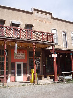 Location of Los Cerrillos, New Mexico
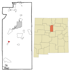
Coordinates: 35°26′14″N 106°7′36″W / 35.43722°N 106.12667°WCoordinates: 35°26′14″N 106°7′36″W / 35.43722°N 106.12667°W Country United States State New Mexico County Santa Fe Area – Total 1.4 sq mi (3.6 km2) – Land 1.4 sq mi (3.6 km2) – Water 0.0 sq mi (0.0 km2) Population (2000) – Total 229 – Density 164.5/sq mi (63.5/km2) Time zone Mountain (MST) (UTC-7) – Summer (DST) MDT (UTC-6) ZIP codes 87010 Area code(s) 505 FIPS code 35-42600 Los Cerrillos is a census-designated place (CDP) in Santa Fe County, New Mexico, United States. It is part of the Santa Fe, New Mexico Metropolitan Statistical Area. The population was 229 at the 2000 census. Accessible from State Highway 14 or The Turquoise Trail, Cerrillos is on the road from Santa Fe to Albuquerque, closer to Santa Fe. There are several shops and galleries, a Post Office and the Cerrillos Hills State Park which contains 5 miles of hiking trails. The Cerrillos Turquoise Mining Museum contains hundreds of artifacts from the American Old West and the Cerrillos Mining District. It also has cardboard cutouts of characters from the film Young Guns and information on other movies which were filmed in and around Cerrillos. This is a good place to view Cerrillos Turquoise from the Brown's turquoise claim, The Little Chalchihuitl.[1]
Contents
Geography
Los Cerrillos is located at 35°26′14″N 106°7′36″W / 35.43722°N 106.12667°W (35.437160, -106.126711)[2]. Los Cerrillos is referred to as Cerrillos by local residents.[3]
According to the United States Census Bureau, the CDP has a total area of 1.4 square miles (3.6 km2), all of it land.
Demographics
As of the census[4] of 2000, there were 229 people, 111 households, and 59 families residing in the CDP. The population density was 164.5 people per square mile (63.6/km²). There were 129 housing units at an average density of 92.7 per square mile (35.8/km²). The racial makeup of the CDP was 79.04% White, 0.44% Native American, 0.44% Asian, 16.16% from other races, and 3.93% from two or more races. Hispanic or Latino of any race were 50.66% of the population.
There were 111 households out of which 21.6% had children under the age of 18 living with them, 42.3% were married couples living together, 7.2% had a female householder with no husband present, and 46.8% were non-families. 41.4% of all households were made up of individuals and 7.2% had someone living alone who was 65 years of age or older. The average household size was 2.06 and the average family size was 2.83.
In the CDP the population was spread out with 17.9% under the age of 18, 2.2% from 18 to 24, 31.9% from 25 to 44, 33.2% from 45 to 64, and 14.8% who were 65 years of age or older. The median age was 44 years. For every 100 females there were 99.1 males. For every 100 females age 18 and over, there were 106.6 males.
The median income for a household in the CDP was $13,661, and the median income for a family was $31,161. Males had a median income of $30,446 versus $31,250 for females. The per capita income for the CDP was $14,215. About 25.9% of families and 18.4% of the population were below the poverty line, including none of those under the age of eighteen or sixty five or over.
History
The Tano Indians were the first people in the Cerrillos, New Mexico area. Their pueblos large and small were spread out randomly throughout the Galisteo Basin. Archaeologists believe that these sites were occupied by the Tano with no more than a few thousand at one time. Some of the pueblos may have been abandoned when the farm lands wore out. Evidence has shown farm land (Burnt Corn Ruin) five miles east of Cerrillos were destroyed in battle. Tumbled stones, broken potsherds and discarded tools of rock were discovered as records of their passing.
Many materials were mined out of Cerrillos. A Spanish explorer Antonio de Espejo wrote about these treasures being mined at a place of “little hills." This is where Cerrillos gots its name. The Pueblo Indians took out turquoise in the hills of Cerrillos. The Spaniards found gold, silver and lead. The Tano Indians were used for slave labor to mine these materials out of the hills of Cerrillos. Several cave-ins on the mines made the Tano stop mining. They protested mining and covered up any existence of the mines. The mines lay dormant for 150 years.
Cerrillos was rediscovered in 1879 by two prospectors from Leadville, Colorado. Word spread fast of the treasures and soon many miners swarmed the hills of Cerrillos. Cerrillos was well known and many people came from around the world to mine these materials for profit. The town started off as a tent city but soon grew into a town of many buildings, homes, a church, a school and stores.
The rapid growth of the town gave opportunity for people who moved in. Hotels were built along with saloons, dance halls, local shops and short order houses. There were not only profits for miners but business that provided for miners. One of the town’s leading businesses was the Cerrillos Supply Company. This company provided equipment that miners needed (shovels, picks, tools, steel and fuses to name a few).
By 1900 the mines began to shut down. The booming town began to dwindle. A fraction of the people stayed in Cerrillos. Today there is only a few of the remaining building up. Some of the building still show evidence of past movies filmed (Young Guns and Outrageous Fortune) on Main Street. The church still stands at the end of Main Street. The local people attend mass on Sunday. There are a few businesses that tourist and locals can use and a petting zoo with a trading post that features Cerrillos turquoise and a mining museum. Cerrillos Hill State Park has 5 miles of multi-use trails with an ADA trail to the village overlook. The State Park is located a half mile north of the village on CR 59.[5]
References
- ^ http://www.cerrillosturquoise.com
- ^ "US Gazetteer files: 2010, 2000, and 1990". United States Census Bureau. 2011-02-12. http://www.census.gov/geo/www/gazetteer/gazette.html. Retrieved 2011-04-23.
- ^ See, for example, the sign over the door at File:Cerrillos store.jpg, in infobox.
- ^ "American FactFinder". United States Census Bureau. http://factfinder.census.gov. Retrieved 2008-01-31.
- ^ http://nmparks.com
Harris, Linda G., Ghost Towns Alive, University of New Mexico Press, 2003
Sherman, James E. and Barbara, Ghost Towns and Mining Camps of New Mexico, University of Oklahoma Press, Norman, Publishing Division of the University, 1975
Simmons, Marc, Turquoise and Six Guns The Story of Cerrillos, New Mexico, The Sunstone Press Santa Fe, New Mexico, 1974
Lawson, Jacqueline E., Cerrillos Yesterday, Today and Tomorrow The Story of a Won’t –Be Ghost Town, The Sunstone Press Santa Fe New Mexico, 1989
http://www.legendsofamerica.com/NM-Cerrillos.html
http://www.sangres.com/newmexico/santafe/cerrillos.htm
Municipalities and communities of Santa Fe County, New Mexico Cities 
Town CDPs Agua Fria | Canada de los Alamos | Cedar Grove | Chimayo‡ | Chupadero | Cuartelez | Cundiyo | Cuyamungue | El Rancho | El Valle de Arroyo Seco | Eldorado at Santa Fe | Galisteo | Glorieta | Jaconita | La Cienega | La Puebla | Lamy | Los Cerrillos | Madrid | Pojoaque | Rio Chiquito | Rio en Medio | San Ildefonso Pueblo | Santa Cruz | Sombrillo | Tesuque
Unincorporated
communitiesNambé Pueblo | Seton Village | Stanley | Waldo
Indian reservation Footnotes ‡This populated place also has portions in an adjacent county or counties
Categories:- Populated places in Santa Fe County, New Mexico
- Census-designated places in New Mexico
- Populated places in New Mexico with Hispanic majority populations


Wikimedia Foundation. 2010.