- Irakleio, Attica
-
For other uses, see Heraklion (disambiguation).
Irakleio
Ηράκλειο
Location 
 Irakleio
Coordinates 38°3′N 23°46′E / 38.05°N 23.767°ECoordinates: 38°3′N 23°46′E / 38.05°N 23.767°E Location within the region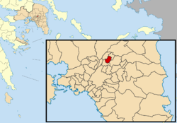
Government Country: Greece Region: Attica Regional unit: North Athens Mayor: Pantelis Vlassopoulos Population statistics (as of 2001) Municipality - Population: 45,926 - Area: 4.638 km2 (2 sq mi) - Density: 9,902 /km2 (25,646 /sq mi) Other Time zone: EET/EEST (UTC+2/3) Elevation (center): 150 m (492 ft) Postal: 144 xx Telephone: 210 Auto: Z Website www.iraklio.gr Irakleio (Greek: Ηράκλειο) is a suburb in the northern part of Athens, Greece, and a municipality of the Attica region. Irakleio is divided into three parts, Palaio Irakleio, Neo Irakleio and Ano Irakleio. The name dates back to ancient times. The name during the Ottoman Empire until the Greek War of Independence was known as Arakli. Irakleio is linked by an ISAP green line of the outdoor subway station. Irakleio is accessed north with two exits with the Attiki Odos (number 6)/E94 which is also accessed with GR-1/E75 (Athens - Lamia - Thessaloniki) and GR-8/E94. It is located about SE of GR-1 and Kifissou Avenue, SW of Marathon, W of Kifissias Avenue, and about 14 km N of Athens via GR-1 and about 3 km S and north of the Attiki Odos (number 6).
There are several main roads in town including one linking Pefki and Kifissia. The main street which accesses to the Olympic Stadium is to the east and Veikou Avenue is also to its east. Business include Kafemporiki Catering SA.
Contents
History
 Irakleio square
Farmlands used to dominate much of the landscape, including groves. During the early to mid 20th century, urban development and industrial buildings replaced much of the farmland. The industrial area are around the northern and the northeastern part of Metafmorfosi. Today, most of the land is residential. The Parnitha can be seen, as can the Penteli mountains to the northeast. The higher parts of the Aegaleo and Hymettus mountains can be seen.
Irakleio has schools, a few lyceums, gymnasia, banks, a train station, a sports centre, cinemas, post offices and squares (plateies). An old stone quarry mine is situated in the area of Ano Heraklio.
- Epikinonia FM, Neo Irakleio's radio station. It is owned by this municipality. - 94.0 FM - http://www.94fm.gr
There are two football teams that compete on local leagues, Hrakleio F.C. which participates in the A Division of the local league and Ermhs Eirhnh in the C Division respectively. Both teams use as their home ground the Prasinou Lofou stadium over Attiki odos.
The earthquake of September 7, 1999 affected the area but caused minor damages.
Historical population
Year Population 1981 37,833 1991 42,905 2001 45,926 See also
- List of municipalities of Attica
References
Northwest: Metamorfosi North: Lykovryssi West: Nea Ionia Heraklio East: Amaroussi and Pefki Southwest: Nea Ionia South: Nea Ionia Administrative division of the Attica Region Area: 3,808km² • Population: 3,761,810 (2001) • Capital: AthensRegional unit of Central AthensAthens • Dafni–Ymittos • Filadelfeia–Chalkidona • Galatsi • Ilioupoli • Kaisariani • Vyronas • Zografou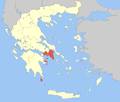 Regional unit of North AthensAgia Paraskevi • Amarousio • Chalandri • Filothei–Psychiko • Irakleio • Kifisia • Lykovrysi–Pefki • Metamorfosi • Nea Ionia • Papagou–Cholargos • Penteli • VrilissiaRegional unit of West AthensRegional unit of South AthensAgios Dimitrios • Alimos • Elliniko–Argyroupoli • Glyfada • Kallithea • Moschato–Tavros • Nea Smyrni • Palaio FaliroRegional unit of PiraeusRegional unit of East AtticaAcharnes • Dionysos • Kropia • Lavreotiki • Marathon • Markopoulo • Oropos • Paiania • Pallini • Rafina–Pikermi • Saronikos • Spata–Artemida • Vari–Voula–VouliagmeniRegional unit of West AtticaRegional unit of IslandsRegional governor: Ioannis Sgouros (el) • Website: www.patt.gov.grCategories:
- Municipalities of Attica
- Populated places in North Athens


Wikimedia Foundation. 2010.