- Dafni–Ymittos
-
Dafni-Ymittos
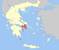
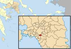
Δάφνη-ΥμηττόςLocation Coordinates 37°57′N 23°43′E / 37.95°N 23.717°ECoordinates: 37°57′N 23°43′E / 37.95°N 23.717°E Government Country: Greece Region: Attica Regional unit: Central Athens Population statistics (as of 2001) Municipality - Population: 34,813 - Area: 2.35 km2 (1 sq mi) - Density: 14,814 /km2 (38,368 /sq mi) Other Time zone: EET/EEST (UTC+2/3) Dafni–Ymittos (Greek: Δάφνη-Υμηττός) is a municipality in the Central Athens regional unit, Attica, Greece. The seat of the municipality is the town Dafni.[1]
Municipality
The municipality Dafni–Ymittos was formed at the 2011 local government reform by the merger of the following 2 former municipalities, that became municipal units:[1]
References
- ^ a b Kallikratis law Greece Ministry of Interior (Greek)
Administrative division of the Attica Region Area: 3,808km² • Population: 3,761,810 (2001) • Capital: Athens Regional unit of Central Athens Regional unit of North AthensAgia Paraskevi • Amarousio • Chalandri • Filothei–Psychiko • Irakleio • Kifisia • Lykovrysi–Pefki • Metamorfosi • Nea Ionia • Papagou–Cholargos • Penteli • VrilissiaRegional unit of West AthensRegional unit of South AthensAgios Dimitrios • Alimos • Elliniko–Argyroupoli • Glyfada • Kallithea • Moschato–Tavros • Nea Smyrni • Palaio FaliroRegional unit of PiraeusRegional unit of East AtticaAcharnes • Dionysos • Kropia • Lavreotiki • Marathon • Markopoulo • Oropos • Paiania • Pallini • Rafina–Pikermi • Saronikos • Spata–Artemida • Vari–Voula–VouliagmeniRegional unit of West AtticaRegional unit of Islands
Regional governor: Ioannis Sgouros (el) • Website: www.patt.gov.gr Categories:- Populated places in Central Athens
- Municipalities of Attica
- Greece geography stubs
Wikimedia Foundation. 2010.


