- Cwmyoy
-
Coordinates: 51°54′10″N 3°01′13″W / 51.90291°N 3.02030°W
Cwmyoy Welsh: Cwm-iou 
St. Martin's Church at Cwmyoy
 Cwmyoy
Cwmyoy shown within MonmouthshireOS grid reference SO299232 Principal area Monmouthshire Ceremonial county Gwent Country Wales Sovereign state United Kingdom Post town ABERGAVENNY Postcode district NP7 Dialling code 01600 Police Gwent Fire South Wales Ambulance Welsh EU Parliament Wales UK Parliament Monmouth List of places: UK • Wales • Monmouthshire Cwmyoy (Welsh: Cwm-iou) is an extensive rural parish in Monmouthshire, Wales. Alternate spellings include Cwm Iau, the name translating from the Welsh as "valley of the yoke"
The village of Cwmyoy is located 7 miles north of Abergavenny and 4 miles south of Llanthony in the Vale of Ewyas in the Black Mountains. It is within the Brecon Beacons National Park, in an upland location just below the broad ridge of Hatterrall Hill, which carries the border between England and Wales and along which runs Offa's Dyke Path.
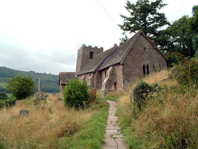
Cwmyoy is best known for its medieval church, which has been called the "most crooked church in Great Britain".[citation needed] The church chancel has been described as a remarkable example of a "weeping chancel", where the nave represents Christ's body and the deflected chancel his head fallen sideways in death. At Cwmyoy not only the axis but the whole chancel slews sideways.[1]
Contents
Cwmyoy Church
St. Martin's parish church is a stone church standing on a steep hillside on the east side of the valley. It was begun in the 12th century, and as it now exists most of the building dates to the 13th century. The church is in the Gothic style, and has a chancel, nave, south porch, and western tower. A round-headed north window dates to the 12th century, and the nave roof has been dated to the late 13th or early 14th century.[2] A stone medieval cross in the church is said to have been a landmark along the pilgrimage route to St. David's Cathedral in Pembrokeshire, Wales.[citation needed]
The underlying geology is of Old Red Sandstone overlying marl, and processes of slippage and subsidence over the centuries have caused the tower and chancel to move in opposite directions, twisting the entire structure. To strengthen the church walls and prevent its collapse, additional support has been provided by massive tie beams and buttresses. The tower supposedly leans at an angle greater than that of the Leaning Tower of Pisa.[citation needed]
The church's windows are 16th century and the communion rails date to the 17th century. The six bells in the tower date to 1672. A number of 18th and 19th century funeral monuments within the church were constructed by three generations of the Brute family of the distant village of Llanbedr, near Crickhowell, Powys. The church was restored in the Victorian era in 1885-89 by J. James Spencer, who did not attempt to straighten the building.[2]
Amongst the gravestones, a modern example consisting of a roughly hewn purple slate pillar is notable. This is located close to the north-west corner of the church, and marks the resting place of the racing driver Arthur Denys Gill (1926-2008), who farmed nearby after retirement from the sport.[3] [4]
The parish
The parish is nearly 8 miles long and 1 mile broad, and includes Llanthony as well as Cwmyoy itself. In 1893, an area in the neighbouring valley of the Grwyne Fawr, known in Welsh as Fwthog and in English as the Fothock, which had been an exclave of Herefordshire, was transferred into the parish.[5]
Local amenities
The Cwmyoy area is popular for hillwalking and pony trekking. Llanthony Priory, Capel-y-ffin and Gospel Pass are all accessed by passing below Cwmyoy village.
References
- ^ Hando, F.J., (1958) "Out and About in Monmouthshire", R. H. Johns, Newport.
- ^ a b John Newman, The Buildings of Wales: Gwent/Monmouthshire, 2000, ISBN 0-14-071053-1
- ^ Historic Racing.com
- ^ The 500 Owners Association
- ^ Kelly's Directory of Monmouthshire, 1901
External links
Categories:- Villages in Monmouthshire
- Black Mountains, Wales

Wikimedia Foundation. 2010.