- Counties (Detached Parts) Act 1844
-
The Counties (Detached Parts) Act 1844 
Parliament of the United KingdomLong title An Act to annex detached Parts of Counties to the Counties in which they are situated. Statute book chapter 7 & 8 Vict. c. 61 Territorial extent England and Wales Dates Royal Assent 6 August 1844 Commencement 20 October 1844 Other legislation Repealing legislation Local Government Act 1972 Status: Repealed The Counties (Detached Parts) Act 1844 (7 & 8 Vict. c. 61), which came into effect on 20 October 1844, was an Act of Parliament of the United Kingdom which eliminated many outliers or exclaves of counties in England and Wales for civil purposes.
The areas involved had already been reorganised for some purposes: The Reform Act 1832 had abolished the outliers for parliamentary constituencies, the Counties (Detached Parts) Act 1839 allowed Justices of the Peace to act for exclaves surrounded by their county, and constabularies established under the County Police Act 1839 had jurisdiction over detached parts of other counties.
Section 1 of the Act read in part as follows:
[F]rom and after the Twentieth Day of October next every Part of any County in England or Wales which is detached from the main Body of such County shall be considered for all Purposes as forming Part of that County of which it is considered a Part for the Purposes of the Election of Members to serve in Parliament as Knights of the Shire [...]
The Act went on to state (s. 2) that the parts transferred would be incorporated in an existing "Hundred, Wapentake, Ward, Rape, Lathe, or other like Division by which it is wholly or for the most Part surrounded, or to which it is next adjoining, in the County to which it will thenceforth belong, unless the Justices of the County, [...] shall declare it to be a new or separate Hundred or other like Division [...]."
The Act itself did not list the areas transferred; these had already been detailed in the Parliamentary Boundaries Act 1832 (2 & 3 Will. 4 c. 64).
The Act transferred the detached parts to different counties but not to different parishes. Unless the detached part was an entire parish, this resulted in many cases of a detached part in one county belonging to a parish in a different county. Later legislation, including the Divided Parishes and Poor Law Amendment Act 1882, eliminated most instances of civil parishes belonging to two (or more) counties, and by 1901 Stanground in Huntingdonshire and the Isle of Ely was the sole remaining example.[1]
Areas transferred
The Act affected twenty-seven counties. The largest changes were to County Durham, which lost large areas to Northumberland, as well as a single parish to Yorkshire. By no means all detached areas were changed: seven counties still had exclaves. Many of these outlying parts changed their administration in the 1890s following the passing of the Local Government Act 1894. Large detached blocks of Warwickshire and Worcestershire interspersed with Gloucestershire remained until 1931, while Flintshire retained two exclaves until 1974 — a large one (the Maelor Saesneg area) east of Wrexham in Denbighshire and a single parish exclave (Marford & Hoseley) north of Wrexham.
Bedfordshire
Transferred to other counties:
- The part of the hamlet of Tetworth (in the parish of Everton) in Bedfordshire transferred to Huntingdonshire
- The part of the parish of Ickleford in Bedfordshire transferred to Hertfordshire
Transferred from other counties:
- The part of the parish of Meppershall in Hertfordshire
- The part of the parish of Studham in Hertfordshire
- The part of the parish of Farndish in Northamptonshire
Berkshire
Transferred to other counties:
- The part of the parish of Great Barrington in Berkshire transferred to Gloucestershire
- The tithing and chapelry of Little Faringdon (in the parish of Langford) transferred to Oxfordshire
- The part of the parish of Shilton in Berkshire transferred to Oxfordshire
- The tithing of Oxenwood (in the parish of Shalbourne) in Berkshire transferred to Wiltshire
- The part of the parish of Inglesham in Berkshire transferred to Wiltshire
Transferred from other counties:
- The part of the parochial chapelry of Hurst (in the parish of Sonning) in Wiltshire
- The part of the parish of Shinfield in Wiltshire
- The part of the parish of Wokingham in Wiltshire
Buckinghamshire
Transferred to other counties:
- The hamlet of Studley (in the parish of Beckley) in Buckinghamshire transferred to Oxfordshire
- The parish of Caversfield transferred to Oxfordshire
- The part of the extra-parochial place of Luffield Abbey in Buckinghamshire transferred to Northamptonshire
- The part of the chapelry of Stratton Audley (in the parish of Bicester) in Buckinghamshire transferred to Oxfordshire
Transferred from other counties:
- The parish of Lillingstone Lovell in Oxfordshire
- The township of Boycott (in the parish of Stowe) in Oxfordshire
- The chapelry of Ackhampstead (in the parish of Lewknor) in Oxfordshire
- The part of the hamlet of Coleshill (in the parish of Amersham) in Hertfordshire
Cornwall
Transferred to other counties:
- The part of the parish of Bridgerule in Cornwall transferred to Devon
Transferred from other counties:
- The part of the parish of St John in Devon
- The part of the parish of Maker in Devon
- The part of the parish of North Tamerton in Devon
Denbighshire
Transferred to other counties:
- The township of Carreghova (in the parish of Llanmynech) transferred to Montgomeryshire
Derbyshire
Transferred to other counties:
- Part of the township of Foston and Scropton (in the parish of Scropton) transferred to Staffordshire
Also:
- The part of the parish of Glossop on the Cheshire side of the River Etherow was declared to be in Derbyshire - its previous status was uncertain
Devon
Transferred to other counties:
- The part of the parish of Maker in Devon transferred to Cornwall
- The part of the parish of St John in Devon transferred to Cornwall
- The part of the parish of North Tamerton in Devon transferred to Cornwall
- The parish of Thorncombe transferred to Dorset
Transferred from other counties:
- The part of the parish of Axminster in Dorset
- The part of the parish of Bridgerule in Cornwall
- The parish of Stockland (including the hamlet of Dalwood) in Dorset
Dorset
Transferred to other counties:
- The part of the parish of Axminster in Dorset transferred to Devon
- The parish of Stockland (including the hamlet of Dalwood) transferred to Devon
Transferred from other counties:
- The parish of Holwell in Somerset
- The parish of Thorncombe in Devon
County Durham
Transferred to other counties:
- Islandshire (consisting of the chapelry of Ancroft, part of the parish of Belford, the township of Holy Island, the chapelry of Kyloe, the extra-parochial place of Monks House and the chapelry of Tweedmouth) transferred to Northumberland
- Bedlingtonshire (the parish of Bedlington) transferred to Northumberland
- Norhamshire (the parish of Norham) transferred to Northumberland
- The extra parochial Farne Islands transferred to Northumberland
- Craikshire (the parish of Crayke) transferred to the North Riding of Yorkshire
Gloucestershire
Transferred to other counties:
- The parish of Little Compton transferred to Warwickshire
- The township of Lea Lower (in the parish of Lea) in Gloucestershire transferred to Herefordshire
- The parish of Minety transferred to Wiltshire
- The parish of Shenington transferred to Oxfordshire
- The parish of Sutton-under-Brailes transferred to Warwickshire
- The parish of Widford transferred to Oxfordshire
Transferred from other counties:
- The hamlets of Alstone and Little Washbourne (both in the parish of Overbury) in Worcestershire
- The part of the parish of Great Barrington in Berkshire
- Great Lemhill Farm (in the parish of Broughton Poggs) in Oxfordshire (placed in the parish of Lechlade)
- The parish of Icomb (including the hamlet of Church Icomb) in Worcestershire
- The parish of Kingswood in Wiltshire
- The parish of Poulton in Wiltshire
Hampshire
Transferred to other counties:
- The tithings of North Ambersham and South Ambersham (both in the parish of Steep) transferred to Sussex
- The part of the parish of Rogate in Hampshire transferred to Sussex
Herefordshire
Transferred to other counties:
- Part of the township of Litton and Cascob (in the parishes of Cascob and Presteigne) transferred to Radnorshire
- The hamlet of Bwlch Trewyn (in the parish of Cwmyoy) transferred to Monmouthshire
- The chapelry of Farlow (in the parish of Stottesden) transferred to Shropshire
- The chapelry of Rochford (in the parish of Tenbury) transferred to Worcestershire
Transferred from other counties:
- The township of Lea Lower (in the parish of Lea) in Gloucestershire
- The parish of Welsh Bicknor in Monmouthshire
Hertfordshire
Transferred to other counties:
- The part of the hamlet of Coleshill (in the parish of Amersham) in Hertfordshire transferred to Buckinghamshire
- The part of the parish of Meppershall in Hertfordshire transferred to Bedfordshire
- The part of the parish of Studham in Hertfordshire transferred to Bedfordshire
Transferred from other counties:
- The part of the parish of Ickleford in Bedfordshire
Huntingdonshire
Transferred from other counties:
- The part of the hamlet of Tetworth (in the parish of Everton) in Bedfordshire. (Tetworth, which became a separate civil parish, remained in two distinct parts, one of which was an exclave of Huntingdonshire until 1965.)
Monmouthshire
Transferred to other counties:
- The parish of Welsh Bicknor transferred to Herefordshire
Transferred from other counties:
- The hamlet of Bwlch Trewyn (in the parish of Cwmyoy) in Herefordshire
Montgomeryshire
Transferred from other counties:
- The township of Carreghova (in the parish of Llanymynech) in Denbighshire
Northamptonshire
Transferred to other counties:
- The part of the parish of Farndish in Northamptonshire transferred to Bedfordshire
Transferred from other counties:
- The part of the extra-parochial place of Luffield Abbey in Buckinghamshire
Northumberland
Transferred from other counties:
- Islandshire (consisting of the chapelry of Ancroft, part of the parish of Belford, the township of Holy Island, the chapelry of Kyloe, the extra-parochial place of Monks House and the chapelry of Tweedmouth) transferred from County Durham
- Bedlingtonshire (the parish of Bedlington) transferred from County Durham
- Norhamshire (the parish of Norham) transferred from County Durham
- The extra parochial Farne Islands transferred from County Durham
Oxfordshire
Transferred to other counties:
- Great Lemhill Farm (in the parish of Broughton Poggs) transferred to Gloucestershire
- The parish of Lillingstone Lovell transferred to Buckinghamshire
- The township of Boycott (in the parish of Stowe) transferred to Buckinghamshire
- The chapelry of Ackhampstead (in the parish of Lewknor) transferred to Buckinghamshire
Transferred from other counties:
- The hamlet of Studeley (in the parish of Beckley) in Buckinghamshire
- The parish of Caversfield in Buckinghamshire
- The tithing and chapelry of Little Faringdon (in the parish of Langford) in Berkshire
- The parish of Shenington in Gloucestershire
- The part of the parish of Shilton in Berkshire
- The part of the chapelry of Stratton Audley (in the parish of Bicester) in Buckinghamshire
- The parish of Widford in Gloucestershire
Shropshire
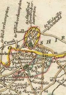
 Dudley, shown on an 1814 map as being an exclave of Worcestershire locally situated in Staffordshire. Note also the exclave of Shropshire at Halesowen, abolished by this Act.
Transferred to other counties:
- The townships of Halesowen, Cakemore, Hasbury, Hawne, Hill, Illey, Lapal, Ridgacre, Hunnington, Oldbury and Romsley (all in the parish of Halesowen) transferred to Worcestershire
Transferred from other counties:
- The chapelry of Farlow (in the parish of Stottesdon) in Herefordshire
Somerset
Transferred to other counties:
Staffordshire
Transferred to other counties:
- The parish of Broome transferred to Worcestershire
- The parish of Clent transferred to Worcestershire
Transferred from other counties:
- Part of the township of Foston and Scropton (in the parish of Scropton) in Derbyshire
Sussex
Transferred from other counties:
- The tithings of North Ambersham and South Ambersham (both in the parish of Steep) in Hampshire
- The part of the parish of Rogate in Hampshire
Warwickshire
Transferred to other counties:
- The township of Tutnall and Cobley (in the parish of Tardebigge) transferred to Worcestershire
Transferred from other counties:
- The parish of Little Compton in Gloucestershire
- The parish of Sutton-under-Brailes in Gloucestershire
Wiltshire
Transferred to other counties:
- The part of the parochial chapelry of Hurst (in the parish of Sonning) in Wiltshire transferred to Berkshire
- The parish of Kingswood transferred to Gloucestershire
- The parish of Poulton transferred to Gloucestershire
- The part of the parish of Shinfield in Wiltshire transferred to Berkshire
- The part of the parish of Wokingham in Wiltshire transferred to Berkshire
Transferred from other counties:
- The part of the parish of Inglesham in Berkshire
- The parish of Minety in Gloucestershire
Worcestershire
Transferred to other counties:
- The parish of Icomb (including the hamlet of Church Icomb) transferred to Gloucestershire
- The hamlets of Alstone and Little Washbourne (both in the parish of Overbury) transferred to Gloucestershire
Transferred from other counties:
- The parish of Broom in Staffordshire
- The parish of Clent in Staffordshire
- The townships of Halesowen, Cakemore, Hasbury, Hawne, Hill, Illey, Lapal, Ridgacre, Hunnington, Oldbury and Romsley (all in the parish of Halesowen) in Shropshire
- The chapelry of Rochford (in the parish of Tenbury) in Gloucestershire
Yorkshire, North Riding
Transferred from other counties:
- The parish of Crayke in County Durham
References
Sources
- Counties (Detached Parts) Act 1844
- Parliamentary Boundaries Act 1832, Schedule M
- Moule, Thomas (1836) Moule's English Counties in the 19th century, London: Simpkin & Marshall, republished (1990) as The County Maps of Old England by Thomas Moule, London: Studio Editions Ltd, ISBN 1-85170-403-5
- Youngs, Frederic A. (1979) Guide to the local administrative units of England, Vol. 1: Southern England, Royal Historical Society, Guides and handbooks no. 10., London : University College, ISBN 0-901050-67-9
- Youngs, Frederic A. (1991) Guide to the local administrative units of England, Vol. 2: Northern England, Royal Historical Society, Guides and handbooks no. 17., London : University College, ISBN 0-86193-127-0
 United Kingdom legislation
Pre-Parliamentary legislation Acts of Parliament by states preceding
the Kingdom of Great BritainActs of the Parliament of England to 1483 · 1485–1601 · 1603–1641 · Interregnum (1642–1660) · 1660–1699 · 1700–1706
Acts of the Parliament of Scotland
Acts of the Parliament of Ireland to 1700 · 1701–1800Acts of Parliament of the
Kingdom of Great Britain1707–1719 · 1720–1739 · 1740–1759 · 1760–1779 · 1780–1800
Acts of Parliament of the United Kingdom of
Great Britain and Ireland and the United
Kingdom of Great Britain and Northern IrelandChurch of England Measures Legislation of devolved institutions Acts of the Scottish Parliament
Acts and Measures of the Welsh Assembly
Acts of the Northern Ireland Assembly / of the Northern Ireland Parliament
Orders in Council for Northern IrelandSecondary legislation Categories:- Local government legislation in England and Wales
- 1844 in law
- Counties of England
- Counties of Wales
- United Kingdom Acts of Parliament 1844
Wikimedia Foundation. 2010.

