- Ixtapan de la Sal
-
Ixtapan de la Sal — Town & Municipality — Main plaza with church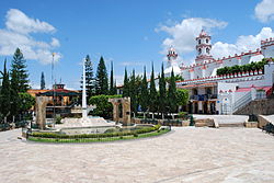
Coordinates: 19°21′40″N 99°21′03″W / 19.36111°N 99.35083°W Country  Mexico
State State of Mexico Founded Municipal Status 1822 Government – Municipal President Salvador Christopher Vergara Cruz (2006-2009) Elevationof seat 1,880 m (6,168 ft) Population (2005)Municipality – Municipality 30,073 – Seat 15,383 Time zone CST (UTC-6) Postal code (of seat) 51900 Demonym Website (Spanish) http://www.edomexico.gob.mx/ixtapandelasal Ixtapan de la Sal is a town and municipality located in the State of Mexico, Mexico. It is 60 km south of Toluca, the state capital. The word Ixtapan comes from Nahuatl. There are two theories as to the origin of the name. The first one states that it is composed of iztal, which means salt, and pan, which means over or in. The second one states that it comes from iztac, which means white, atl, which means water; and pan, which means in white waters. "de la Sal" is Spanish for "of salt".[1]
Contents
The town
As of the 2005 census, the town had a population of 15,383.[2] Two rivers pass through Ixtapan de la Sal. They are “El Rio Salado” from the east with a year-round current, and “El Rio Salitre” from the northwest with a seasonal current. Also an aqueduct passes through the city. But the most relevant part for tourists is the carbonated water of “La Laguna Verde,” a spring which filters from the subsoil sprouting naturally in form of water eruptions.[1]
On January 22, 1981, Ixtapan de la Sal officially became a city. In 1996, it was integrated to the program of the “100 Colonial Cities”, which is a tousitic program that gathers the oldest as well as the most important Mexican cities.[1]
Tourism
The city of Ixtapan de la Sal has as its primary economic activity the tourism generated by the thermal springs that are found here. It is considered to be one of the primary tourist destinations in the State of Mexico. Many internationally-known hotel chains have locations here, most often placed on or right next to a thermal spring.[3] The best known of these hotel-spas are the famous Ixtapan Spa Hotel and Golf Resort, Marriott Ixtapan de la Sal, Hotel Rancho San Diego Grand Spa Resort, and Rey Ixtapan de la Sal. These resorts offer guests baths in volcanically-heated waters, massages, beauty treatments and other services.[4]
It is also the home of the Parque Acuatico Ixtapan a water park with thermal spring spa, a children's area, a family area and an area dedicated to "extreme" water rides.[5] The park also has an expanse of green area with a small train that tours it.[4]
Fifteen kilometers to the south of the city are located the Grutas de la Estrella. These are caverns that have been formed by the dissolving of limestone by groundwater that seeps from the Chontalcuatlan and San Jeronimo rivers. These caverns are filled with stalactites and stalagmites of various colors.[4]
The municipality
As municipal seat, the town of Ixtapan de la Sal has governing jurisdiction over the following communities: Ahuacatitlán, Barrio Santa Ana, Coaxusco, Colonia Juárez, Colonia la Joya Tres de Mayo Lindavista, El Arenal de las Ollas, El Colorín, El Refugio, El Rincón de Dios Yerbas Buenas, El Salitre, Ixtamil, La Falda, Llano de la Unión, Llano de San Diego, Los Naranjos, Malinaltenango (Manila), Mesón Nuevo, Plan de San Miguel, Portezuelos Dos, Portezuelos Uno (San Andrés), Puerta Grande (Puerta de los Fresnos), Rancho San Diego, San Alejo, San Diego Alcalá (San Diego), San José del Arenal (El Arenal), San Miguel Laderas (San Miguel), San Pedro Tlacochaca, Santa Ana Xochuca, Tecomatepec (San Pedro Tecomatepec), Tlacochaca, Yautepec, and Yerbas Buenas.
Demographic information
The population of the municipality according the 2005 census is 30,073 51% of the population lives in the town of Ixtapan de la Sal itself and 48.1% live in the surrounding municipality.[6]
There are currently 114 schools with about 566 teachers. The illiteracy rate is 12.6%. 48.8% of the population is economically active.[7]
Government
The government is formed by:
- Municipal president
- Attorney General
- 10 deputies
The municipality also has a Secretary, Director of Municipal Public Works, Municipal Administrator, Director of Municipal Development, Municipal Security Chief, Municipal Slaughterhouse Administrator, Chief of Human and Material Resources, Director of Sports, Administrator of Natural Springs, Director of Water Works and sanitation and Director of Civil Protection.
These authorities have jurisdiction over both the town and municipality of Ixtapan de la Sal.
In each communitu belonging to the municipality, 3 representatives are chosen to help in the government and to represent their neighbors. In each community, there are also 2 or 3 of these representatives that help with security and with some government projects.[1]
History
In the year 1394, a group of indigenous people came from the Pacific coast. They wanted to get to Tenochtitlan in order to attend the crowning of the emperor. On their way to their destination, these Pacific people established in Ixtapan de la Sal where they formed communities. Here they noticed that once the geothermacally heated water was evaporated naturally in the sunlight, salt was formed. This amazed them because back then, salt was a very precious item. When the emperor found out about this discovery, he also ordered men and women to move there, which led to the foundation of Ixtapan de la Sal.[7]
At the time of the Spanish conquest, Hernán Cortés sent Andrés de Tapia to conquer Ixtapan de la Sal. The first priest who came to Ixtapan was Juan Guichen de Leyva.[7] Evangelization was carried out by Franciscans who came here after 1543. Tradition states that 13 monks came to Ixtapan de la Sal to convert the Indians by associating Christ with the local deity associated with storms.[1]
In 1822, Ixtapan de la Sal became a municipality of the state of Mexico. In 1825, the first elections to select the municipal council took place on Sunday December 3 of the same year. On August 9 and 10, 1912, the population of Ixtapan de la Sal was attacked by “pseudo–Zapatistas”, who are followers of Zapata's ideology. The invaders were led by Andres Ruiz and Francisco B. Pacheco. On August 1, 1918, by council’s agreement, local mourning was declared for every year’s August 10.[7]
Geographical information
Ixtapan borders the municipalities of Coatepec Harinas to the northwest, Villa Guerrero to the northeast, and Zumpahuacán to the east, the municipality of Tonatico and the state of Guerrero to the south, and the municipality of Zacualpan to the west.[1]
The climate in Ixtapan de la Sal is predominately cool, semi-arid with rains in the summer. It has an average temperature of 17.9 °C (64 °F) and a low of 1 °C (34 °F) which results in a comfortable place for health and for relaxing.
There is a great variety of plant species in Ixtapan de la Sal, among which are found watercress, borage, camomille, pine, cedar, ash tree, jacaranda, avocado, date palmTrees, "reeds", "rue", arnico, "holm oak", "oyamel fir", "aile", causarina, "Mexican fig tree", "cabrillo", cazahauates, liquorice, tepeguaj and pirul. It has a wide variety of animals which includes rabbits, squirrels, sparrowhawks, quails, iguanas, badgers, coyotes, wild cats, skunks, ferrets, foxes, American badgers, tuzas, opossums, mockingbirds and cacomixtles, but also you can find insects, birds and reptiles.[7]
Traditions
Popular celebrations
On the second Friday of Lent the annual religious celebration in honor to the Lord of Forgiveness is celebrated.
On August 15, a religious festival in honor of the Assumption of Mary takes place.[8]
Traditions
For nine days after the passing of a loved one, prayers are offered for the deceased. On the ninth day, a wooden cross that has been laid on the ground is raised upright and carried to the tomb to be placed there permanently. Another tradition that is practiced in Ixtapan is the “Sunday open-air market", which is a market placed in the same place every Sunday. In it, people practice “El trueque" (bartering).[8]
Dances
The most important is the one called "Apaches”, which is represented by local townspeople on September 15 and 16
in memory of the celebration of the Mexican War of Independence from the stronghold of the Spanish conquest, led by Don Miguel Hidalgo y Costilla Miguel Hidalgo y Costilla
Music
The traditional one is the “Banda del Viento” (the wind band), which still persists. Its members play musical instruments without formal music studies.[8]
Arts and crafts
The principal handcrafts are pottery, carved wood and confectionery and also the production of pipían pumpkin candy in October and November. The most prominent are the wooden copalillo and pottery.[7]
References
- ^ a b c d e f "Enciclopedia de los Municipios de Mexico Estado de México - Ixtapan de la Sal". http://www.e-local.gob.mx/work/templates/enciclo/mexico/mpios/15040a.htm.
- ^ "Principales resultados por localidad 2005 (ITER)". http://www.inegi.gob.mx/est/contenidos/espanol/sistemas/conteo2005/localidad/iter/default.asp?s=est&c=10395. Retrieved 2008-03-08.
- ^ "Ixtapan de la Sal". Archived from the original on 2008-02-19. http://web.archive.org/web/20080219080127/http://www.cddiputados.gob.mx/POLEM54/INESLE/COLOQUIO/IXTAPAN/IXTAPAN.HTML. Retrieved 2008-03-08.
- ^ a b c Quintanar Hinojosa, Beatriz (August 2007). "Ixtapan de la Sal". Guía México Desconocido: Estado de Mexico 136: 32–34. ISSN 1870-9400. http://www.mexicodesconocido.com.mx.
- ^ "Parque Acuatico Ixtapan". http://www.parqueixtapan.com/mapa.htm. Retrieved 2008-03-08.
- ^ "Gobierno del Estado de Mexico". http://www.edomexico.gob.mx/newweb/Gobierno%20en%20internet/PAGMUN/Mun_Ixt%20de%20la%20S.asp.
- ^ a b c d e f "Ixtapan de la Sal". http://www.elclima.com.mx/ixtapan_de_la_sal.htm.
- ^ a b c INEGI (1997). Guia Turistica del Estado de Mexico. Instituto Nacional de Estadistica, Geografia e Informatica. ISBN 970-13-1194-9.
Coordinates: 18°50′N 99°41′W / 18.833°N 99.683°W
 State of Mexico
Municipalities Acambay · Acolman de Nezahualcóyotl · Aculco · Almoloya de Alquisiras · Almoloya de Juárez · Almoloya del Río · Amanalco · Amatepec · Amecameca · Apaxco · San Salvador Atenco · Santa Cruz Atizapán · Ciudad López Mateos · Atlacomulco · Atlautla · Axapusco · Ayapango · Buenavista · Calimaya · Capulhuac · Chalco de Díaz Covarrubias · Chapa de Mota · Chapultepec · Chiautla · Chicoloapan · Chiconcuac · Chimalhuacán · Coacalco de Berriozábal · Coatepec Harinas · Cocotitlán · Coyotepec · Cuautitlán · Cuautitlán Izcalli · Donato Guerra · Ecatepec de Morelos · Ecatzingo · El Oro · Huehuetoca · Hueypoxtla · Huixquilucan · Ixtapaluca · Ixtapan de la Sal · Ixtapan del Oro · Ixtlahuaca · Jaltenco · Jilotepec · Jilotzingo · Jiquipilco · Jocotitlán · Joquicingo · Juchitepec · Los Reyes Acaquilpan · Lerma · Luvianos · Malinalco · Melchor Ocampo · Metepec · Mexicaltzingo · Morelos · Naucalpan · Nextlalpan · Nezahualcóyotl · Ciudad Nicolás Romero · Nopaltepec · Ocoyoacac · Ocuilán · Otumba · Otzoloapan · Otzolotepec · Ozumba · Papalotla · Polotitlán · San Antonio la Isla · San Felipe del Progreso · San Martín de las Pirámides · San Mateo Atenco · San Simón de Guerrero · Santo Tomás de los Plátanos · Soyaniquilpan · Sultepec · Tecámac · Tejupilco · Temamatla · Temascalapa · Temascalcingo · Temascaltepec · Temoaya · Tenancingo de Degollado · Tenango del Aire · Tenango del Valle · Teoloyucan · Teotihuacán de Arista · Tepetlaoxtoc · Tepetlixpa · Tepotzotlán · Tequixquiac · Texcaltitlán · Texcalyacac · Texcoco de Mora · Tezoyuca · Tianguistenco · Timilpan · Tlalmanalco · Tlalnepantla · Tlatlaya · Toluca · Tonatico · Tonanitla · Tultepec · Tultitlán · Valle de Bravo · Xico · Villa de Allende · Villa del Carbón · Villa Guerrero · Villa Victoria · Xalatlaco · Xonacatlán · Zacazonapan · Zacualpan · Zinacantepec · Zumpahuacán · Zumpango
 Categories:
- Populated places in the State of Mexico
- Municipalities of the State of Mexico


Wikimedia Foundation. 2010.