- Chalco de Díaz Covarrubias
-
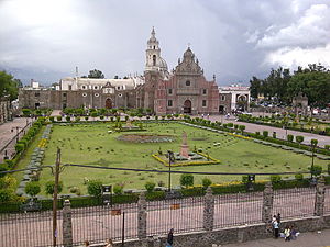
Chalco (de Díaz Covarrubias) — Town & Municipality — Church Coordinates: 19°15′53″N 98°53′51″W / 19.26472°N 98.8975°W Country  Mexico
State State of Mexico Founded Municipal Status 1824 Government – Municipal President Vicente Alberto Onofre Vázquez (2006-2009) Elevationof seat 2,240 m (7,349 ft) Population (2010)Municipality – Municipality 310,130 – Seat 168,720 Time zone CST (UTC-6) Postal code (of seat) 56600 Demonym Website Official site Chalco de Díaz Covarrubias is a city that is municipal seat of the surrounding municipality of Chalco. It lies in the eastern part of the state of México, just east of the Federal District of Mexico and is considered part of the Mexico City metropolitan area.
Contents
The city
Its church was constructed in 1585, after being evangelized by the Franciscans and has been considered a city since 1861. The city had a 2010 census population of 168,720 inhabitants. It is an important center for dairy production as well as the manufacturing of thread and yarn of wool and cotton. A major employer is the San Rafael paper factory. [1] Government sources mention that the helicopter where Francisco Blake Mora traveled collided in this municipality, leaving 8 top government officials dead.[2]
The municipality of Chalco
As the municipal seat, the city of Chalco de Díaz Covarrubias has governing jurisdiction over the following communities:
Ampliación de San Pedro, Barrio de Guadalupe, Camino a Cruz de Cortés, Camino al Monte, Caserío de Cortez, Colonia Calle Santa Cruz Amalinalco, Colonia del Moral, Colonia Emiliano Zapata (Besana de Inclán), Colonia Guadalupe de los Tepetates, Colonia Jazmín de las Flores (El Jazmín), Colonia Marco Antonio Sosa Balderas, Colonia Michoacana, Colonia San José, Colonia San José Axalco, Ejido San Marcos, El Coyote, El Molinito, El Naranjo, El Recodo de San José Axalco, El Tlalchichil, Granja Guadalupana, Granja San Javier, Granja San José, Granja Santa Anita, Granja Sonora, Hacienda del Moral (El Moral), Huixtomatitla (Tepalcates), Instituto Damián (Ex-hda. San Juan de Dios), Kilómetro 39 Carretera México Cuautla, La Candelaria Tlapala, La Chimenea, La Longaniza, La Magueyera, La Taberna, Las Colonias, Llano del Moral, Lomas de San Pablo, Los Almendrales, Los Arenales, Los Hornos, Paraje las Nieves, Paseos de Chalco, Paso del Oyamel, Pozo el Cuartito Número Dos, Rancho Amigo, Rancho del Ahuehuete, Rancho el Corazón, Rancho el Cupido, Rancho Elodia, Rancho Maravillas, Rancho Nuevo, Rancho Nuevo San Miguel, Rancho San Jorge, Rancho San Miguel, Rancho Santa María Atoyac, Rancho Tamariz (Rancho la Caballeriza), San Gregorio Cuautzingo, San Juan y San Pedro Tezompa, San Lucas Amalinalco, San Marcos Huixtoco, San Martín Cuautlalpan, San Mateo Huitzilzingo, San Mateo Tezoquipan, San Pablo Atlazalpan, Santa Ana (Predio San Juan), Santa Catarina Ayotzingo, Santa María Huexoculco, and Subestación de Luz Chalco
The municipality, which has an area of 234.72 km² (90.626 sq mi), had a population of 310,130 inhabitants at the 2010 census.
Chalco is often confused with the Valle de Chalco Solidaridad municipality as the name Chalco is a part of both. The major difference is that Valle de Chalco Solidaridad is located near the ancient Lake Chalco. In fact, Chalco is interconnected to Valle de Chalco through Avenida Solidaridad.
Towns and villages
Chalco is one of only three municipalities in Mexico that have at least nine localities of over 10,000 inhabitants. (It and Tijuana Municipality, Baja California both have nine, while Tlajomulco de Zúñiga Municipality, Jalisco has eleven.) The largest localities (cities, towns, and villages) are:[3]
Name 2010 Census Population Chalco de Díaz Covarrubias 168,720 San Martín Cuautlalpan 23,501 San Mateo Huitzilzingo 15,389 San Gregorio Cuautzingo 13,138 Santa María Huexoculco 12,456 San Marcos Huixtoco 12,229 San Juan Tezompa 11,819 San Pablo Atlazalpan 11,236 Santa Catarina Ayotzingo 10,702 Total Municipality 310,130 History of the area
The first civilization which arrived to what today is Chalco were the Acxotecas. According to Chimalpahin, they came from Tula and named themselves "chalcas" The second group arriving were the Mihuaques, who hadn't leaders and adopted those ones of the Acxotecas. Circa 1160, the Chichimecas Teotenancas arrived from the Toluca valley and came across Tlahuac. They all together formed the Chalca civilization. They lived there until 1510, when the Spanish conquistadors arrived. The place remained without inhabitants until the early 20th century. The municipality has expanded to the limits of Mexico City. Now many capitalinos (residents of the capital) are moving to Chalco looking for more peace and tranquility also because housing prices are so high in Mexico City.
Transportation
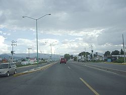
Chalco is served by the State of Mexico collective transports divided in geographical areas (AG-##) locating Chalco within the AG-10. Volkswagen vans ("combis" or "colectivos") transport people from the municipality to the boundaries of the Federal District in order to let people take the subway from that point into the inner Mexico City. Several colectivos also run from Chalco to Mexico City's Benito Juárez International Airport.
See also
- Universidad Azteca
Notable people
- Antonio Pujol (1913–1995), painter
References
- ^ "Chalco de Díaz Covarrubias". Archived from the original on 2009-10-31. http://www.webcitation.org/5kwQmC3RK. Retrieved 2008-03-07.
- ^ "El helicóptero de Blake Mora tomó una ruta distinta por la nubosidad". CNN Mexico. http://mexico.cnn.com/nacional/2011/11/12/el-helicoptero-de-blake-mora-tomo-una-ruta-distinta-por-la-nubosidad. Retrieved 13 November 2011.
- ^ 2010 census tables: INEGI
- 2010 census tables: INEGI: Instituto Nacional de Estadística, Geografía e Informática
- México Enciclopedia de los Municipios de México
 State of Mexico
Municipalities Acambay · Acolman de Nezahualcóyotl · Aculco · Almoloya de Alquisiras · Almoloya de Juárez · Almoloya del Río · Amanalco · Amatepec · Amecameca · Apaxco · San Salvador Atenco · Santa Cruz Atizapán · Ciudad López Mateos · Atlacomulco · Atlautla · Axapusco · Ayapango · Buenavista · Calimaya · Capulhuac · Chalco de Díaz Covarrubias · Chapa de Mota · Chapultepec · Chiautla · Chicoloapan · Chiconcuac · Chimalhuacán · Coacalco de Berriozábal · Coatepec Harinas · Cocotitlán · Coyotepec · Cuautitlán · Cuautitlán Izcalli · Donato Guerra · Ecatepec de Morelos · Ecatzingo · El Oro · Huehuetoca · Hueypoxtla · Huixquilucan · Ixtapaluca · Ixtapan de la Sal · Ixtapan del Oro · Ixtlahuaca · Jaltenco · Jilotepec · Jilotzingo · Jiquipilco · Jocotitlán · Joquicingo · Juchitepec · Los Reyes Acaquilpan · Lerma · Luvianos · Malinalco · Melchor Ocampo · Metepec · Mexicaltzingo · Morelos · Naucalpan · Nextlalpan · Nezahualcóyotl · Ciudad Nicolás Romero · Nopaltepec · Ocoyoacac · Ocuilán · Otumba · Otzoloapan · Otzolotepec · Ozumba · Papalotla · Polotitlán · San Antonio la Isla · San Felipe del Progreso · San Martín de las Pirámides · San Mateo Atenco · San Simón de Guerrero · Santo Tomás de los Plátanos · Soyaniquilpan · Sultepec · Tecámac · Tejupilco · Temamatla · Temascalapa · Temascalcingo · Temascaltepec · Temoaya · Tenancingo de Degollado · Tenango del Aire · Tenango del Valle · Teoloyucan · Teotihuacán de Arista · Tepetlaoxtoc · Tepetlixpa · Tepotzotlán · Tequixquiac · Texcaltitlán · Texcalyacac · Texcoco de Mora · Tezoyuca · Tianguistenco · Timilpan · Tlalmanalco · Tlalnepantla · Tlatlaya · Toluca · Tonatico · Tonanitla · Tultepec · Tultitlán · Valle de Bravo · Xico · Villa de Allende · Villa del Carbón · Villa Guerrero · Villa Victoria · Xalatlaco · Xonacatlán · Zacazonapan · Zacualpan · Zinacantepec · Zumpahuacán · Zumpango
 Categories:
- Municipalities of the State of Mexico
- Populated places in the State of Mexico
Wikimedia Foundation. 2010.


