- Atlacomulco
Infobox Settlement
official_name =
name = Atlacomulco (de Fabela)
other_name =
native_name =
nickname =
settlement_type = Town & Municipality
total_type =Municipality
motto =
imagesize =
image_caption =
flag_size =
image_
seal_size =
image_shield =
shield_size =
city_logo =
citylogo_size =
mapsize =
map_caption =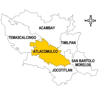
mapsize1 =
map_caption1 =
image_dot_
dot_mapsize =
dot_map_caption =
dot_x = |dot_y =
pushpin_
pushpin_label_position =
pushpin_map_caption =
pushpin_mapsize =
subdivision_type = Country
subdivision_name = MEX
subdivision_type1 = State
subdivision_name1 =State of Mexico
subdivision_type2 =
subdivision_name2 =
subdivision_type3 =
subdivision_name3 =
subdivision_type4 =
subdivision_name4 =
government_footnotes =
government_type =
leader_title = Municipal President
leader_name = Lucas Caballero (2006-2009)
leader_title1 =
leader_name1 =
leader_title2 =
leader_name2 =
leader_title3 =
leader_name3 =
leader_title4 =
leader_name4 =
established_title = Founded
established_date =
established_title2 = Municipal Status
established_date2 = August 4, 1824
established_title3 =
established_date3 =
area_magnitude =
unit_pref =
area_footnotes =
area_total_km2 = 258.74
area_land_km2 =
area_water_km2 =
area_total_sq_mi =
area_land_sq_mi =
area_water_sq_mi =
area_water_percent =
area_urban_km2 =
area_urban_sq_mi =
area_metro_km2 =
area_metro_sq_mi =
area_blank1_title =
area_blank1_km2 =
area_blank1_sq_mi =
population_as_of = 2005
population_footnotes = Municipality
population_note =
population_total = 77,831
population_density_km2 =
population_density_sq_mi =
population_blank1_title = Seat
population_blank1 = 20,447
population_blank2_title =
population_blank2 =
population_density_blank1_km2 =
population_density_blank1_sq_mi =
timezone = CST
utc_offset = -6
timezone_DST =
utc_offset_DST =
latd=19 | latm=03 | latNS=N | longd=99 | longm=22 | longEW=W
elevation_footnotes = of seat
elevation_m = 2570
elevation_ft =
postal_code_type = Postal code (of seat)
postal_code = 50450
area_code =
blank_name =
blank_info =
blank1_name =Demonym
blank1_info =
website = http://www.atlacomulco.gob.mx
footnotes =Atlacomulco de Fabela (simply known as Atlacomulco) is a city and the seat of the municipality of Atlacomulco located in the northwest of the State of Mexico, about 63 km from the state capital,
Toluca . The word "Atlacomulco" means “The place where the water wells are” and it comes fromNahuatl .cite web |url=http://www.e-local.gob.mx/work/templates/enciclo/mexico/mpios/15014a.htm |title=Plan de desarrollo municipal de Atlacomulco 1997-2000 |accessdate=2007-10-15 |author=Gobierno del Estádo de México |language=Spanish]The city
The city was formed by the joining of two haciendas, with El Toshi contributing 18,716.10 hectares and El Salto contributing 1,539.93 hectares. The development of Atlacomulco began between 1911 and 1950 with the construction of many schools in the center of the municipality and spreading to the outer communities.
Important residents
Isidro Fabela Alfaro (1882-1964), was a lawyer, teacher, federal deputy, writer and publisher. Some of his works are "La tristeza del amor" (The sadness of love), "Los prescursores de la diplomacia Mexicana" (The precursors of the Mexican diplomacy) and "Historia Diplomatica de la Revolucion Mexicana" (Diplomatic History of the Mexican Revolution). He was mayor of Atlacomulco from 1942 to 1945. The national conference leading to "Precursores de la Politica Extrangera Mexicana" (Precursors of the Mexican Foreign Policy) on October 24, 1996, was recorded with gold letters on behalf of him on the floor of the Congress.cite web |url=http://www.biografiasyvidas.com/biografia/f/fabela.htm |title=Biografía de Isidro Fabela |accessdate=2007-11-13 |author=Biografías y Vidas |language=Spanish]In public administration,
Mario Sánchez Colín (1922-1983) played different roles such as: director of the Literary and Scientific Institute of the State of México. He produced a comprehensive cultural and academic program during his administration. As a federal deputy, he edited books for free distribution to youth, as well as creating publications such as: "Testimonios de Atlacomulco" (Testimonials of Atlacomulco) and the "Enciclopedia del Estádo de México" (Encyclopedia of the State of Mexico). He was also the initiator of the construction of the first "Casa de la Cultura" (House of Culture) and the founder of the organization of municipal archives of the State of Mexico.cite web |url=http://www.desdelolocal.gob.mx/work/templates/enciclo/mexico/hist.htm |title=Atlacomulco |accessdate=2007-11-13 |author=Instituto Nacional para el Federalismo y el Desarrollo Municipal del Gobierno del Estado de México. |language=Spanish]Salvador Sánchez Colín (1912-) was governor of the State of México from 1951 to 1957. During his tenure, he focused on cultural, moral and intellectual advancement. He was also a prominent agronomist.Cirenio Malaquias Huitrón Velasco (1881-1971) was a distinguished politician. He held very important positions as a public servant. He worked in one of the first municipal laws of the state and in the formulation of a bill for civil service.Alfredo del Mazo Velez (1904-1975) performed efficient administrative work. He worked on several social projects to help people in Atlacomulco.Roberto Barrios Castro (1908-1994) was a great politician and writer. He was school director besides a cultural promoter. He was one of the founders of theMexican Revolution celebration and head of the Agricultural Department. He was the Latin American representative at the International Labor Organization, studying agrarian reform, inGeneva ,Switzerland . He wrote "6 Años de Políticas en la Agricultura del PresidenteAdolfo López Mateos " (6 Years of agricultural policy of PresidentAdolfo López Mateos ), and "El Hombre es la Tierra" (Man is the land).Maximino Ruiz y Flores was born in Atlacomulco on 1875. He was a bishop in Chiapas. He had a prominent church and a true apostle in the diocese of Chiapas, mainly with the Indians. He was an important writer very committed to religion. He died in 1949 but he is still remembered in Atlacomulco.Arturo Velez Martinez (1904-1989) was appointed parish priest of San Bartolo Otzolotepec, which forms part of the Atlacomulco municipality, where he spent the most productive years of his life. In April 1951, he was named as the first bishop of the Diocese of Toluca, and built the current cathedral and the seminary.The municipaltity
As the municipal seat of Atlacomulco, Atlacomulco de Fabela has governing jurisdiction over the following communities:
Bobashi de Guadalupe, Bombatevi Ejido (Ej. Santa Cruz Bombatevi), Cerrito Colorado, Chosto de los Jarros, Cuartel Quinta Sección el Puente, Cuendo, Diximoxi, Dolores la Joya (La Joya), Ejido Boro, Ejido de San José del Tunal, Ejido del Rincón, Ejido de la Candelaria), Ejido el Calvario Santiago Acutzilapan, Ejido la Palma (La Palma), El Cielito, El Espejel, El Jacal, El Magueyal, El Manto de la Estación, El Rincón de la Candelaria, El Salto, La Alcantarilla, La Isla de las Aves (La Presa), La Mesa de Chosto, Lagunita Cantashí, Las Manzanas (La Joya), Las Mercedes, Las Tarrias, Loma de Chivatí, Manto del Río Ejido, Manto del Río Pueblo, Maye el Fresno, Puenroo, Quinto Cuartel de San Pedro del Rosal, Rancho Cote, Rancho Cotecito, Rancho Guadalupe (Rancho Blanco), Rancho la Querencia (Rancho el Porvenir), Rancho las Ánimas, Rancho los Fresnos, Rancho San Francisquito, Rancho San Isidro, Rancho San Joaquín, Rancho San Vicente, San Antonio Enchisi, San Bartolo el Arenal, San Bartolo Lanzados, San Felipe Pueblo Nuevo, San Francisco Chalchihuapan, San Ignacio de Loyola, San Jerónimo de los Jarros, San José del Tunal, San José Toxi, San Juan de los Jarros, San Lorenzo Tlacotepec, San Luis Boro, San Martín de los Manantiales, San Pablo Atotonilco (Atotonilco), San Pedro del Rosal, Santa Cruz Bombatevi, Santiago Acutzilapan, Santo Domingo Shomege (Shomege), Tecoac (Santa María Nativitas), Tierras Blancas, and Zona Industrial
History
In the beginning, Atlacomulco was ruled by Mazahuas since an unknown date. After the Spanish conquest, Atlacomulco was entrusted to
Francisco de Villegas , ofSpain on November 8, 1535. A royal charter was issued on December 19, 1536, a transfer authorized by the king, giving the rights to his deputy inMadrid on April 29, 1536.During the War of Independence
Miguel Hidalgo , in front of the insurgent army, crossed the northwestern part of Atlacomulco in November, 1810 as one of the most important events of the XVIII century in this municipality.Ignacio López Rayón also crossed the southwest part of the municipality a few months later.Once Mexican Independence was gained in 1824, the municipality of Atlacomulco was established in August 4th of the same year. All this historical information is in the municipal archives in the "Oldest Town" section, and it was signed by
Agustín Peláez , the first mayor of Atlacomulco.Nowadays, this municipality is considered one of the most developed in the State of Mexico because of its industrial zone and its proximity to Pasteje, an industrial plant which is an important source of employment. It is also considered as the birthplace of many distinguished people related to the religious and economic fields.
The reason why Atlacomulco has gained prominence in
Mexico is thanks to “The Atlacomulco Group”, which is how many politicians of this municipality have been unofficially known. This group includes many governors of Mexico such asIsidro Fabela Alfaro ,Alfredo del Mazo Vélez ,Salvador Sanchez Colín ,Arturo Montiel Rojas and the actual governorEnrique Peña Nieto .Political geography
Atlacomulco is located in the northwest of the State of Mexico inside the coordinates of the parallels 19’43’37” and 19’43’67” north. It is between the meridians 99’42’12” and 99’52’48” west. Its altitude varies from 2,640 to 2,720 above sea level. Atlacomulco has a total expansion of 258.74 square kilometers that represent the 1.19% of the total territory of the State of Mexico.
Atlacomulco is bounded to the north by
Acambay andTemascalcingo , to the east bySan Bartolo Morelos andSan Andrés Timilpan , to the south byJocotitlán , to the west byTemascalcingo and El Oro. The distance between Atlacomulco andToluca , the capital of Mexico State, is 63 kilometers approximately.Natural geography
Atlacomulco is situated on the transversal volcanic axis that crosses México in an area of lakes and volcanoes called "
Anahuac ". Also, Atlacomulco is part of theJocotitlan foothills.Mountains
The main mountains in Atlacomulco are
Xitije , Atlacomulco, La Cruz,El Cielito ,El Nogal , San Miguel,Tepari ,Lashco andCantaxi .Rivers, lakes, basins and springs
Atlacomulco is near the
Lerma River river and has 31 springs. Atlacomulco has many lakeside parks such as Lerma,Zacoalpan ,Atotonilco , El Salto, Los Corrales,La Huerta ,Mabati ,Tierras Blancas , Santiago, Pueblo Nuevo y Ojo de Agua. The climate in Atlacomulco is sub-tropical with a rainy season in the summer. The average high temperature is about 19.9 °C and the average low is 7.4°C.Demographics
In the 2005
census , Atlacomulco had a total population of 77,831 people, and 8,829 of them speak an ethnic dialect such as: Mazahua, Náhuatl, and Otomí among others.cite web |url=http://www.edomexico.gob.mx/newweb/Gobierno%20en%20internet/PAGMUN/Mun_Atlacomulco.asp |title=Datos estadísticos del Estádo de México |accessdate=2007-11-12 |author=Gobierno del Estádo de México|language=Spanish]Economy
The economy of Atlacomulco is based on
agriculture and stockbreeding. The principal crops are corn, wheat, barley and oats. 60% of production of these products is for local consumption and only 40% is for trade.San Lorenzo Tlacotepec is a small village nearby where the people raise plants, principally plants for decoration.Gastronomy
Among the culinary delights of Atlacomulco are "barbacoa" (pit-barbecued
mutton )withconsome , "carnitas " (chopped pork) and a salad called "juanes", composed of nopales, tomato, coriander, pork rind, avocado, cheese and peas. As for drinks, it is recommended to try fruit drinks made with several fruits from the region such as: mango, watermelon, strawberry, etc. as well aspulque .cite web| url=http://edomexico.turista.com.mx/atlacomulco-viewarticle-41.html |title=Turistic guide of Atlacomulco| accessdate=2007-11-12| author=Gobierno del Estádo de México]Tourism
The springs called "Las Fuentes" are a popular place for family recreation outdoors located en the center of Atlacomulco. Only 14 km from Atlacomulco, in Lake J. Trinidad Fabela is located "La Isla de las Aves" (The Island of Birds), with appropriate facilities to enjoy countryside walks. This small island in the middle of the reservoir harbors bird diversity such as: pigeons, geese, ducks, Guinea chickens, among others. This natural park is part of a program to preserve the ecosystem of Atlacomulco and to prevent the extinction of many species.
Nearby, the "Parque El Ocotal"(El Ocotal Park), in the municipality of
Timilpan , offers visitors the opportunity to enjoy forests, a small zoo, boats to practice rowing and horseback riding and is frequented for camping and picnics."Isidro Fabela Park" is a natural park that belongs to the state and it is located in “Cerro Viejo”.
Among craft work in the region are pieces of pottery jars, pots, barrels and "comales" (flat pan for cooking tortillas), hats, sarapes and miniature musical instruments. All these products can be purchased at the Sunday open-air market.
References
Further reading
* "Ayuntamiento de Atlacomulco" (1997). Plan de desarrollo municipal de Atlacomulco 1997-2000 (in Spanish), Atlacomulco México: Ayuntamiento de Atlacomulco.
* "Marisol del Socorro Arias Flores" (1998). Monografía municipal de Atlacomulco (in Spanish). Toluca México: Instituto Mexiquense de Cultura.
Wikimedia Foundation. 2010.