- Crosby, Minnesota
-
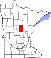
Crosby, Minnesota — City — Motto: Founded by George H. Crosby Location of Crosby, Minnesota
Coordinates: 46°28′55″N 93°57′29″W / 46.48194°N 93.95806°W Country United States State Minnesota County Crow Wing Area – Total 3.7 sq mi (9.5 km2) – Land 3.0 sq mi (7.9 km2) – Water 0.6 sq mi (1.6 km2) Elevation 1,260 ft (384 m) Population (2010)[1] – Total 2,386 – Density 795.3/sq mi (302.0/km2) Time zone Central (CST) (UTC-6) – Summer (DST) CDT (UTC-5) ZIP code 56441 Area code(s) 218 FIPS code 27-13924[2] GNIS feature ID 0642478[3] 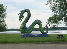 This serpent, on the edge of Serpent Lake, welcomes visitors to Crosby, Minnesota.
Crosby is a city in Crow Wing County, Minnesota, United States. The population was 2,386 at the 2010 census.[1] It is part of the Brainerd Micropolitan Statistical Area. Crosby is adjacent to its twin city of Ironton. It is one of the cities in the Cuyuna Range.
Contents
History
This was a town that was built for the sole purpose of mining. It was plotted out and planned to make sure that it was not on top of any iron ore. In the 1932 local elections, the voters of Crosby elected Karl Emil Nygard as President of the Village Council and thus became the first city in the United States to have a Communist mayor.
Crosby was the location of the worst mining disaster in Minnesota, the Milford Mine disaster.[4] On February 5, 1924, a new tunnel was blasted too close to nearby Foley Lake, and water rushed in, killing 41 miners.
In August 1957, Dr. David Simons, a 35-year-old Air Force major, climbed to nearly 102,000 feet (31,000 m) above the Earth as part of Project Manhigh. The flight, which was launched from the 400-foot-deep (120 m) Portsmouth Mine Pit Lake in Crosby, helped the country take its fledgling steps into space exploration. Simons returned to Crosby in 2007 to mark the anniversary of the Man High project. [5]
Geography
According to the United States Census Bureau, the city has a total area of 3.7 square miles (9.6 km2), of which, 3.0 square miles (7.8 km2) of it is land and 0.7 square miles (1.8 km2) of it (16.94%) is water.
Transportation
Minnesota Highway 6 and Minnesota Highway 210 are two of the main routes in the community.
Demographics
Historical populations Census Pop. %± 1920 3,500 — 1930 3,451 −1.4% 1940 2,954 −14.4% 1950 2,777 −6.0% 1960 2,629 −5.3% 1970 2,241 −14.8% 1980 2,218 −1.0% 1990 2,073 −6.5% 2000 2,299 10.9% 2010 2,386 3.8% U.S. Decennial Census As of the census[2] of 2000, there were 2,299 people, 989 households, and 554 families residing in the city. The population density was 755.0 people per square mile (292.0/km²). There were 1,081 housing units at an average density of 355.0 per square mile (137.3/km²). The racial makeup of the city was 97.69% White, 0.04% African American, 0.91% Native American, 0.22% Asian, 0.09% Pacific Islander, 0.35% from other races, and 0.70% from two or more races. Hispanic or Latino of any race were 1.00% of the population. 23.9% were of German, 14.1% Norwegian, 11.7% Swedish, 9.6% American and 7.0% English ancestry according to Census 2000.
There were 989 households out of which 27.6% had children under the age of 18 living with them, 40.3% were married couples living together, 11.8% had a female householder with no husband present, and 43.9% were non-families. 39.4% of all households were made up of individuals and 21.2% had someone living alone who was 65 years of age or older. The average household size was 2.18 and the average family size was 2.93.
In the city the population was spread out with 24.4% under the age of 18, 8.1% from 18 to 24, 21.9% from 25 to 44, 20.0% from 45 to 64, and 25.6% who were 65 years of age or older. The median age was 42 years. For every 100 females there were 85.3 males. For every 100 females age 18 and over, there were 79.5 males.
The median income for a household in the city was $24,053, and the median income for a family was $31,629. Males had a median income of $28,879 versus $20,842 for females. The per capita income for the city was $15,465. About 15.6% of families and 16.9% of the population were below the poverty line, including 17.8% of those under age 18 and 12.9% of those age 65 or over.
Notable residents
- Robert A. Good, physician
- Robert M. Polich, Sr.: World War II Pilot, Prisoner of War, Distinguished Flying Cross Recipient
- Anthony "The Bullet" Bonsante: Professional Boxer
Radio stations
FM radio
- 104.3 KLKS Timeless music, CNN and local news, Great Lakes Weather Service Meteorologists
References
- ^ a b "2010 Census Redistricting Data (Public Law 94-171) Summary File". American FactFinder. U.S. Census Bureau, 2010 Census. http://factfinder2.census.gov/faces/tableservices/jsf/pages/productview.xhtml?pid=DEC_10_PL_GCTPL2.ST13&prodType=table. Retrieved 23 April 2011.
- ^ a b "American FactFinder". United States Census Bureau. http://factfinder.census.gov. Retrieved 2008-01-31.
- ^ "US Board on Geographic Names". United States Geological Survey. 2007-10-25. http://geonames.usgs.gov. Retrieved 2008-01-31.
- ^ Brainerd-Crosby Lakes Area Trail System | Cuyuna Country | Crosby - Ironton | Attractions
- ^ http://www.brainerddispatch.com/stories/042110/obi_20100421026.shtml
Municipalities and communities of Crow Wing County, Minnesota Cities Baxter | Brainerd | Breezy Point | Crosby | Crosslake | Cuyuna | Deerwood | Emily | Fifty Lakes | Fort Ripley | Garrison | Ironton | Jenkins | Manhattan Beach | Nisswa | Pequot Lakes | Riverton | Trommald
Townships Bay Lake | Center | Crow Wing | Daggett Brook | Deerwood | Fairfield | Fort Ripley | Gail Lake | Garrison | Ideal | Irondale | Jenkins | Lake Edwards | Little Pine | Long Lake | Maple Grove | Mission | Nokay Lake | Oak Lawn | Pelican | Perry Lake | Platte Lake | Rabbit Lake | Roosevelt | Ross Lake | Sibley | St. Mathias | Timothy | Wolford
Unorganized
territoriesUnincorporated
communityLake Hubert
Indian
reservationGhost town Coordinates: 46°28′56″N 93°57′28″W / 46.48222°N 93.95778°W
Categories:- Cities in Minnesota
- Minnesota populated places on the Mississippi River
- Populated places in Crow Wing County, Minnesota
- Brainerd micropolitan area
- Mining communities in Minnesota


Wikimedia Foundation. 2010.