- Deerwood, Minnesota
-
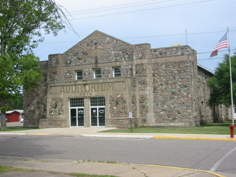
Deerwood, Minnesota — City — The Deerwood Auditorium in Deerwood is on the National Register of Historic Places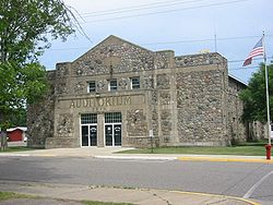 Location of Deerwood, Minnesota
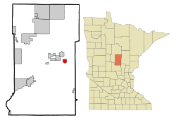
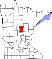
Coordinates: 46°28′25″N 93°54′7″W / 46.47361°N 93.90194°WCoordinates: 46°28′25″N 93°54′7″W / 46.47361°N 93.90194°W Country United States State Minnesota County Crow Wing Area – Total 2.0 sq mi (5.3 km2) – Land 1.4 sq mi (3.5 km2) – Water 0.7 sq mi (1.7 km2) Elevation 1,276 ft (389 m) Population (2010)[1] – Total 532 – Density 380.0/sq mi (161.2/km2) Time zone Central (CST) (UTC-6) – Summer (DST) CDT (UTC-5) ZIP code 56444 Area code(s) 218 FIPS code 27-15346[2] GNIS feature ID 0642741[3] Deerwood is a city in Crow Wing County, Minnesota, United States. The population was 532 at the 2010 census.[1] It is part of the Brainerd Micropolitan Statistical Area.
Contents
Geography
According to the United States Census Bureau, the city has a total area of 2.0 square miles (5.2 km2), of which, 1.4 square miles (3.6 km2) of it is land and 0.7 square miles (1.8 km2) of it (32.84%) is water. Minnesota State Highways 6 and 210 are two of the main routes in the community.
Demographics
Historical populations Census Pop. %± 1910 586 — 1920 532 −9.2% 1930 552 3.8% 1940 570 3.3% 1950 572 0.4% 1960 527 −7.9% 1970 448 −15.0% 1980 580 29.5% 1990 524 −9.7% 2000 590 12.6% 2010 532 −9.8% U.S. Decennial Census As of the census[2] of 2000, there were 590 people, 256 households, and 153 families residing in the city. The population density was 431.1 people per square mile (166.3/km²). There were 309 housing units at an average density of 225.8 per square mile (87.1/km²). The racial makeup of the city was 97.12% White, 1.02% African American, 1.19% Native American, 0.17% Asian, 0.17% from other races, and 0.34% from two or more races. Hispanic or Latino of any race were 0.51% of the population.
There were 256 households out of which 28.1% had children under the age of 18 living with them, 46.9% were married couples living together, 9.4% had a female householder with no husband present, and 40.2% were non-families. 37.1% of all households were made up of individuals and 23.0% had someone living alone who was 65 years of age or older. The average household size was 2.30 and the average family size was 3.08.
In the city the population was spread out with 27.1% under the age of 18, 6.1% from 18 to 24, 22.2% from 25 to 44, 21.7% from 45 to 64, and 22.9% who were 65 years of age or older. The median age was 41 years. For every 100 females there were 88.5 males. For every 100 females age 18 and over, there were 88.6 males.
The median income for a household in the city was $30,069, and the median income for a family was $40,625. Males had a median income of $28,750 versus $27,813 for females. The per capita income for the city was $15,697. About 8.4% of families and 13.9% of the population were below the poverty line, including 18.3% of those under age 18 and 13.9% of those age 65 or over.
Places of interest
The Deerwood Auditorium is a community center built as a Works Progress Administration project. The auditorium, built in 1935, is listed on the National Register of Historic Places, a rare surviving example of federal relief architecture in Minnesota.
References
- ^ a b "2010 Census Redistricting Data (Public Law 94-171) Summary File". American FactFinder. U.S. Census Bureau, 2010 Census. http://factfinder2.census.gov/faces/tableservices/jsf/pages/productview.xhtml?pid=DEC_10_PL_GCTPL2.ST13&prodType=table. Retrieved 23 April 2011.
- ^ a b "American FactFinder". United States Census Bureau. http://factfinder.census.gov. Retrieved 2008-01-31.
- ^ "US Board on Geographic Names". United States Geological Survey. 2007-10-25. http://geonames.usgs.gov. Retrieved 2008-01-31.
Municipalities and communities of Crow Wing County, Minnesota Cities Baxter | Brainerd | Breezy Point | Crosby | Crosslake | Cuyuna | Deerwood | Emily | Fifty Lakes | Fort Ripley | Garrison | Ironton | Jenkins | Manhattan Beach | Nisswa | Pequot Lakes | Riverton | Trommald
Townships Bay Lake | Center | Crow Wing | Daggett Brook | Deerwood | Fairfield | Fort Ripley | Gail Lake | Garrison | Ideal | Irondale | Jenkins | Lake Edwards | Little Pine | Long Lake | Maple Grove | Mission | Nokay Lake | Oak Lawn | Pelican | Perry Lake | Platte Lake | Rabbit Lake | Roosevelt | Ross Lake | Sibley | St. Mathias | Timothy | Wolford
Unorganized
territoriesUnincorporated
communityLake Hubert
Indian
reservationGhost town Categories:- Cities in Minnesota
- Populated places in Crow Wing County, Minnesota
- Brainerd micropolitan area


Wikimedia Foundation. 2010.