- Nisswa, Minnesota
-
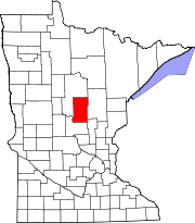
Nisswa, Minnesota — City — Location of Nisswa, Minnesota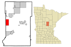
Coordinates: 46°30′29″N 94°17′39″W / 46.50806°N 94.29417°W Country United States State Minnesota County Crow Wing Area – Total 18.4 sq mi (47.6 km2) – Land 10.9 sq mi (28.2 km2) – Water 7.5 sq mi (19.5 km2) Elevation 1,230 ft (375 m) Population (2010)[1] – Total 1,971 – Density 180.8/sq mi (69.9/km2) Time zone Central (CST) (UTC-6) – Summer (DST) CDT (UTC-5) ZIP code 56468 Area code(s) 218 FIPS code 27-46348[2] GNIS feature ID 0648560[3] Website www.ci.nisswa.mn.us 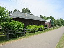 The former Northern Pacific Railway depot in Nisswa now serves as a historical museum. The railroad right-of-way is now the Paul Bunyan Trail.
Nisswa (pronunciation: /ˈnɪswə/ niss-wə) is a city in Crow Wing County, Minnesota, United States. The population was 1,971 at the 2010 census.[1] It is part of the Brainerd Micropolitan Statistical Area. The city is near Gull Lake. This city is well known as a tourist destination due to its many unique stores including Stonehouse Coffee, a coffee shop and cafe that roasts beans in the store, an ice cream parlor and candy shop, The Chocolate Ox, and Zaiser's, a renowned shoe store with many other slightly random items. The Paul Bunyan Bike trail also runs through Nisswa.
Contents
History
Smiley Township was founded in 1900, but local resident Leon Lum convinced residents to rename it Nisswa, from the Ojibwe word "nessawae" (which means "in the middle" or "three"), when the town was incorporated as a village in 1908. On December 4, 1946, Nisswa became a municipality.
Geography
Surrounded by lakes, Nisswa is part of the Brainerd Lakes Area.
Minnesota Highway 371 serves as a main route in the city.
According to the United States Census Bureau, the city has a total area of 18.4 square miles (48 km2), of which, 10.9 square miles (28 km2) of it is land and 7.5 square miles (19 km2) of it (40.84%) is water.
Demographics
Historical populations Census Pop. %± 1930 214 — 1940 400 86.9% 1950 578 44.5% 1960 742 28.4% 1970 1,011 36.3% 1980 1,407 39.2% 1990 1,391 −1.1% 2000 1,953 40.4% 2010 1,971 0.9% U.S. Decennial Census As of the census[2] of 2000, there were 1,953 people, 819 households, and 577 families residing in the city. The population density was 179.5 people per square mile (69.3/km²). There were 1,532 housing units at an average density of 140.8 per square mile (54.4/km²). The racial makeup of the city was 98.87% White, 0.26% African American, 0.10% Native American, 0.15% Asian, 0.10% Pacific Islander, 0.10% from other races, and 0.41% from two or more races. Hispanic or Latino of any race were 0.41% of the population.
There were 819 households out of which 25.5% had children under the age of 18 living with them, 63.0% were married couples living together, 4.3% had a female householder with no husband present, and 29.5% were non-families. 24.3% of all households were made up of individuals and 10.9% had someone living alone who was 65 years of age or older. The average household size was 2.37 and the average family size was 2.81.
In the city the population was spread out with 22.2% under the age of 18, 4.7% from 18 to 24, 25.9% from 25 to 44, 29.4% from 45 to 64, and 17.8% who were 65 years of age or older. The median age was 43 years. For every 100 females there were 102.8 males. For every 100 females age 18 and over, there were 100.3 males.
The median income for a household in the city was $48,306, and the median income for a family was $54,931. Males had a median income of $37,772 versus $29,412 for females. The per capita income for the city was $26,265. About 2.7% of families and 4.9% of the population were below the poverty line, including 6.5% of those under age 18 and 5.8% of those age 65 or over.
Radio stations
FM radio
- 104.3 KLKS Timeless music, CNN and local news, Great Lakes Weather Service
- 94.7 KSKK (FM) Soft Rock, CBS news and local weather, Awesome 80's
- 107.5 KLIZ (FM) The Power Loon
References
- ^ a b "2010 Census Redistricting Data (Public Law 94-171) Summary File". American FactFinder. U.S. Census Bureau, 2010 Census. http://factfinder2.census.gov/faces/tableservices/jsf/pages/productview.xhtml?pid=DEC_10_PL_GCTPL2.ST13&prodType=table. Retrieved 23 April 2011.
- ^ a b "American FactFinder". United States Census Bureau. http://factfinder.census.gov. Retrieved 2008-01-31.
- ^ "US Board on Geographic Names". United States Geological Survey. 2007-10-25. http://geonames.usgs.gov. Retrieved 2008-01-31.
External links
- Nisswa Chamber of Commerce -- Visitor Information site
- City of Nisswa, MN -- Official site
- MN Field Trip article - Link
Municipalities and communities of Crow Wing County, Minnesota Cities Baxter | Brainerd | Breezy Point | Crosby | Crosslake | Cuyuna | Deerwood | Emily | Fifty Lakes | Fort Ripley | Garrison | Ironton | Jenkins | Manhattan Beach | Nisswa | Pequot Lakes | Riverton | Trommald
Townships Bay Lake | Center | Crow Wing | Daggett Brook | Deerwood | Fairfield | Fort Ripley | Gail Lake | Garrison | Ideal | Irondale | Jenkins | Lake Edwards | Little Pine | Long Lake | Maple Grove | Mission | Nokay Lake | Oak Lawn | Pelican | Perry Lake | Platte Lake | Rabbit Lake | Roosevelt | Ross Lake | Sibley | St. Mathias | Timothy | Wolford
Unorganized
territoriesUnincorporated
communityLake Hubert
Indian
reservationGhost town Coordinates: 46°31′14″N 94°17′19″W / 46.52056°N 94.28861°W
Categories:- Cities in Minnesota
- Populated places in Crow Wing County, Minnesota
- Brainerd micropolitan area


Wikimedia Foundation. 2010.