- Cyr Plantation, Maine
-
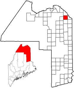
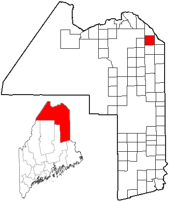
Cyr Plantation is a plantation in Aroostook County, Maine, United States. The population was 117 at the 2000 census.
Geography
According to the United States Census Bureau, the plantation has a total area of 38.4 square miles (99 km2), all of it land.
Demographics
As of the census[1] of 2000, there were 117 people, 42 households, and 33 families residing in the plantation. The population density was 3.0 people per square mile (1.2/km²). There were 51 housing units at an average density of 1.3 per square mile (0.5/km²). The racial makeup of the plantation was 94.02% White, and 5.98% from two or more races.
There were 42 households out of which 45.2% had children under the age of 18 living with them, 71.4% were married couples living together, 2.4% had a female householder with no husband present, and 21.4% were non-families. 16.7% of all households were made up of individuals and 9.5% had someone living alone who was 65 years of age or older. The average household size was 2.79 and the average family size was 3.15.
In the plantation the population was spread out with 30.8% under the age of 18, 4.3% from 18 to 24, 29.9% from 25 to 44, 24.8% from 45 to 64, and 10.3% who were 65 years of age or older. The median age was 40 years. For every 100 females there were 88.7 males. For every 100 females age 18 and over, there were 107.7 males.
The median income for a household in the plantation was $32,500, and the median income for a family was $31,429. Males had a median income of $23,333 versus $21,563 for females. The per capita income for the plantation was $10,836. There were 12.5% of families and 9.9% of the population living below the poverty line, including 5.0% of under eighteens and none of those over 64.
References
- ^ "American FactFinder". United States Census Bureau. http://factfinder.census.gov. Retrieved 2008-01-31.
- "Plantation of Cyr". Geographic Names Information System, U.S. Geological Survey. 1 September 1995. http://geonames.usgs.gov/pls/gnispublic/f?p=gnispq:3:::NO::P3_FID:582430. Retrieved 2010-03-10.
Categories:- Plantations in Aroostook County, Maine

Wikimedia Foundation. 2010.