- Chorrillos District
-
Chorrillos — District — 
Coat of armsLocation of Chorrillos in Lima
Country  Peru
PeruRegion Lima Province Lima Founded Government - Mayor Augusto Miyashiro Yamashiro Area - Total 38.94 km2 (15 sq mi) Elevation 37 m (121 ft) Population (2005 census) - Total 262,595 - Density 6,743.6/km2 (17,465.8/sq mi) Time zone PET (UTC-5) UBIGEO 150108 Website munichorrillos.gob.pe Chorrillos is a district of the Lima Province in Peru and part of the city of Lima. It gets its name from the Spanish word for "trickle of water". The district was originally founded as San Pedro de los Chorrillos and served as a deluxe beach resort until the late 19th century, when it was almost completely destroyed by Chilean forces during the War of the Pacific.
The current mayor of Chorrilos is Augusto Miyashiro Yamashiro.
Contents
Geography
The district has a total land area of 38.94 km². Its administrative center is located 37 meters above sea level.
Boundaries
- North: Barranco and Santiago de Surco
- East: San Juan de Miraflores and Villa El Salvador
- South and west: Pacific Ocean
Demographics
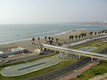 View of the Chorrilos coastal area
According to the 2005 census by the INEI, the district has 262,595 inhabitants, a population density of 6,743.6 persons/km² and 60,353 households.
Attractions
It is famous for its beach resorts at La Herradura, its restaurants, particularly the picanterías (specialising in spicy dishes).
A planetarium (planetario) is located here, built on the historical Morro Solar. From Chorrillos, you can also enjoy a panoramic view of the bay of Lima and out to La Punta (Spanish for point, headland) and the San Lorenzo Island in Callao.
The only natural protected area in metropolitan Lima, the Pantanos de Villa Reserved Zone, is located in Chorrillos.
History
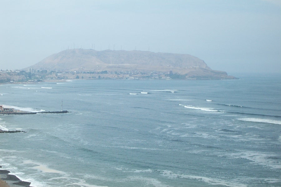
 View of the Morro Solar
The area around the Morro Solar was once a pre-Columbian town known as Armatambo. Following the Spanish conquest of Peru, however, the hillside settlement was abandoned (no trace of it remains today due to neglect and willful destruction) and forgotten, as the Indians began to move down to shore. The resulting town of San Pedro de los Chorrillos was officially established as the District of Chorrillos on January 2, 1857.
The district's territory was the setting of important episodes in the War of the Pacific against Chile (1879–1883). The so called Battle of Chorrillos took place in the fields of San Juan, about 7 miles away from the town on January 13, 1881; but after the battle, the Chilean soldiers looted, sacked and set fire to the town of Chorrillos, raped the women and killed many civilians, including foreigners, children and women. There is a nameplate inside the Fire Station that remembers the names of the Italian firemen who were executed by a Chilean fire squad for attempting to put out the fires and save the civilian population. From republican times, only a select group of the large old houses have survived, as the majority were destroyed by Chilean invaders.
Notable persons from Chorrillos
Famous Peru national football team midfielder Roberto Palacios grew up in Chorrillos, and that is why he is nicknamed El Chorrillano.
The Taekwondo Pan American Champion of Peru, Jean Carlos Gamarra grew up in Chorrillos and founded a Community Taekwondo Program for the impoverished children of "Delicias," a poor neighborhood of the district. His community program has gained the attention of Mayor Augusto Miyashiro and the Federación Deportiva Peruana de Taekwondo in the past.
The Afro-Peruvian singer Susana Baca is from Chorrillos.
The fisherman José Olaya (José Silverio Olaya Balandra), (1782 - †1823), martyr during the struggle for independence and national hero, was born in Chorrillos.
The former Minister of Education Ramón Miranda Ampuero was born there.
Festivities
 Lord of Miracles (Saint Peter Church)
- June: Saint Peter
- October: Lord of Miracles
External links
- Municipalidad de Chorrillos
- Chorrillos.pe - Information about Chorrillos
Lima and Callao Metropolitan Area Culture · History · Landmarks · Notable people · Mayors · Other elected officials · Transportation Districts Central Lima Breña · La Victoria · Lima · Rimac South Central Lima Barranco · Jesús María · La Molina · Lince · Magdalena · Miraflores · Pueblo Libre ·San Borja · San Isidro · San Miguel · Santiago de Surco · Surquillo Cono Este Ate · Cieneguilla · Chaclacayo · El Agustino · Lurigancho (Chosica) · San Juan de Lurigancho · San Luis · Santa Anita Cono Norte Ancón · Carabayllo · Comas · Independencia · Los Olivos · Puente Piedra · San Martin de Porres · Santa Rosa Cono Sur Chorrillos · Lurín · Pachacamac · Pucusana · Punta Hermosa · Punta Negra · San Bartolo · San Juan de Miraflores · Santa María del Mar · Villa el Salvador · Villa María del Triunfo Callao Bellavista · Callao District · Carmen de la Legua Reynoso· La Perla · La Punta · Ventanilla Categories:- Districts of Lima


Wikimedia Foundation. 2010.