Pachacamac District

Pachacamac District

Infobox District Peru
district = Pachacamac
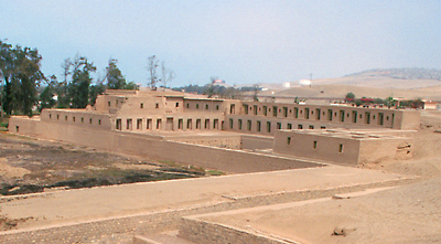


image_size =
image_caption = Pachacamac archaeological site
cofarms = COA Pachacamac District in Lima Province.png

region =
province = Lima
elevation = 75
capital = Pachacamac
hamlets = 11 populated centers
ubigeo = 150123
pop = 54,763
density = 341.8
area = 160.23
founded = January 2, 1857
mayor = Hugo León Ramos Lescano
web = www.munipachacamac.gob.pe
The Pachacamac District is one of 43 districts of the Lima Province in Peru. The capital of the district is the village of Pachacamac. Its main asset is the archaeological Inca site Pachacamac.

History

Pachacamac was first encountered by Hernándo Pizarro on January 30, 1530 while on his quest for gold and his search for a location of a new capital. In 1573 the city of "Santísimo Salvador de Pachacámac" was founded. In 1857 Pachacamac was founded as a republican district. [es Pachacamac Municipality, [http://www.munipachacamac.gob.pe/historia.html History] , Retrieved October 31, 2007.]

Location

The district is located in the southern part of the Lima province at an elevation of 75m.

Political division

The district is divided into 11 populated centers ( _es. Centros Poblados):

* Pachacamac
* Puente Manchay
* Tambo Inga
* Pampa Flores
* Manchay Alto Lote B
* Invasion Cementerio
* Manchay Bajo
* Santa Rosa de Mal Paso
* Cardal
* Jatosisa
* Tomina

Capital

The capital of the Pachacamac district is the village of Pachacamac.

References

External links

* [http://www.munipachacamac.gob.pe Official web site]


Wikimedia Foundation. 2010.

Игры ⚽ Нужно решить контрольную?

Look at other dictionaries:

  • Pachacámac — Pachacamac  Pour l’article homonyme, voir Pachacamac (dieu).  Site archéologique de Pachacamac Pays Pérou District Lur …   Wikipédia en Français

  • District d'Ancón — Le dictrict d’Ancón est l’un des 43 districts de la province de Lima au Pérou. Il fut créé le 29 octobre 1874. Il s’agit d’une station balnéaire ancienne située à environ 40 kilomètres au nord du Centre historique de Lima et accessible par la… …   Wikipédia en Français

  • Lurín District — Infobox District Peru district = Lurín image size = image caption = cofarms = COA Lurín District in Lima Province.png region = province = Lima capital = Lurín elevation = 9 hamlets = ubigeo = 150119 pop = 55,953 (2005 census) density = 308.9 area …   Wikipedia

  • Lima District — For other uses, see Lima District (disambiguation). Lima   District   The Lima Cathedral …   Wikipedia

  • Miraflores District, Lima — Miraflores   District   Coat of arms …   Wikipedia

  • San Martín de Porres District — San Martín de Porres   District   Coat of arms …   Wikipedia

  • Huallanca District, Huaylas — Infobox District Peru cofarms = region = Ancash province = Huaylas district = Huallanca capital = Huallanca pop = commas|985 density = commas|5.5 area = commas|178.8 founded = April 14 1950 elevation = 1377 hamlets = ubigeo = 021202 web =… …   Wikipedia

  • Chorrillos District — Chorrillos   District   Coat of arms …   Wikipedia

  • Callao District — For other uses, see Callao (disambiguation). Callao   District   …   Wikipedia

  • Comas District, Lima — Comas   District   Coat of arms …   Wikipedia

Share the article and excerpts

Direct link
Do a right-click on the link above
and select “Copy Link”