- Marengo (department)
-
Département de Marengo Département of French Revolution and First French Empire ← 
1802–1814 →

Flag Coat of arms Admimistrative map of French Empire in 1812. Marengo (department) is on the lower right side, northwest of Genoa.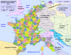
Capital Alessandria
44°55′N 08°37′E / 44.917°N 8.617°ECoordinates: 44°55′N 08°37′E / 44.917°N 8.617°EHistory - Decree of 24 Fructidor, year X[1] 11 September 1802 - Treaty of Fontainebleau 11 April 1814 Area - 1810[2] 3,482.61 km2 (1,345 sq mi) Population - 1810[2] 318,447 Density 91.4 /km2 (236.8 /sq mi) Political subdivisions 3 Arrondissements [2] Marengo is the name of a département of the consulate and of the First French Empire in present Italy. It was named after the Marengo ("Marengh" in piedmontese) plain near Alessandria to commemorate the Battle of Marengo (1800). The capital was Alessandria and the other principal cities were Asti, Bobbio, Casale Monferrato, Tortona and Voghera. The department was suppressed following the defeat of Napoleon in 1814 and the restoration of his Piedmontese territories to the King of Sardinia.
It was formed in 1802 when Napoleon Bonaparte occupied Piedmont. Initially it comprised the former Piedmontese provinces of Alessandria, Casale, Tortona, Voghera and Bobbio. Following the annexation of the Ligurian Republic to France in 1805, Voghera, Bobbio and Tortona passed to the newly created Department of Genoa, while the Department of Marengo acquired Asti, previously in the Department of Tanaro. The subsequent territorial organisation of the department was as follows:
- Arrondissement of Alessandria
- cantons of Felizzano, Valenza, Castellazzo, Cassine, Sezzé, Bosco;
- Arrondissement of Asti
- cantons of Cocconato, Castelnuovo, Montafia, Villanova d'Asti, Montechiaro, Tigliole, San Damiano, Portacomaro, Rocca d'Arazzo, Costigliole, Mombercelli, Canelli;
- Arrondissement of Casale
- cantons of Gabiano, Moncalvo, Pontestura, Rosignano, Ticineto, Montemagno, San Salvatore.
The division was included within the 28th military division, the 16th cohort of the légion d'honneur, the 29th conservation des forêts, the Diocese of Casale, the sénatorerie of Turin and the court of appeal of Genoa. It elected three deputies to the Corps législatif of the First Empire.
In 1810 it covered an area of 348,261 hectares and had a population of 318,447.
References
- ^ "Décret du 24 Fructidor". http://www.histoire-empire.org/docs/bulletin_des_lois/organisation_empire/annexion_piemont_11_09_1802.htm. Retrieved 28-09-2010.
- ^ a b "L'ALMANACH IMPÉRIAL POUR L'ANNÉE 1810, CHAPITRE X, Sect. II, Landes - Marengo". http://www.napoleon-series.org/research/almanac/chapter10/c_chapter10e.html. Retrieved 28-09-2010.
Notes
- This article includes text translated from ‘Dipartimento di Marengo’, its counterpart in the Italian Wikipedia.
Territories annexed by the First French Empire (1804–1814) 44 départements (now parts of Luxembourg, Belgium, the Netherlands, Germany, Italy, Switzerland and Spain) created from annexed territoriesAlpes-Maritimes · Apennins · Arno · Bouches-de-l'Èbre / Bouches-de-l'Èbre-Montserrat · Bouches-de-l'Elbe · Bouches-de-l'Escaut · Bouches-de-l'Yssel · Bouches-de-la-Meuse · Bouches-du-Rhin · Bouches-du-Weser · Deux-Nèthes · Doire · Dyle · Ems-Occidental · Ems-Oriental · Ems-Supérieur · Escaut · Forêts · Frise · Gênes · Jemmape · Léman · Lippe · Lys · Marengo · Méditerranée · Meuse-Inférieure · Mont-Blanc · Montserrat · Mont-Terrible · Mont-Tonnerre · Montenotte · Ombrone · Ourthe · Pô · Rhin-et-Moselle · Roer · Rome · Sambre-et-Meuse · Sarre · Sègre / Sègre-Ter · Sésia · Simplon · Stura · Tanaro · Taro · Ter · Tibre · Trasimène · Yssel-Supérieur · Zuyderzée
Categories:- States and territories established in 1802
- States and territories disestablished in 1814
- Former departments of France in Italy


Wikimedia Foundation. 2010.