- California State Route 39
-
State Route 39
Route information Defined by S&HC § 339 Maintained by Caltrans Length: 50.017 mi[2] (80.495 km)
SR 39 is broken into pieces due to an unconstructed portion, and the length does not reflect the gap.Existed: 1934[1] – present Section 1 South end:  SR 1 in Huntington Beach
Major
junctions: I-5 in Buena Park
 SR 90 in La Habra
North end: South Covina city limit Section 2 South end: North Azusa city limit Major
junctions: I-10 in West Covina
North end:  SR 2 in Angeles National Forest
Highway system State highways in California(list • pre-1964)
History • Unconstructed • Deleted • Freeway • Scenic←  SR 38
SR 38I-40  →
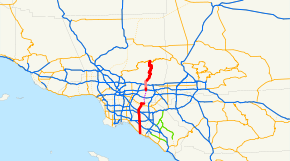
→State Route 39 (SR 39) is a state highway in the U.S. state of California that travels through Orange and Los Angeles counties. Its southern terminus is at Pacific Coast Highway (SR 1), in Huntington Beach, and its northern terminus is at Islip Saddle on Angeles Crest Highway (SR 2) in the Angeles National Forest.
Contents
Route description
This route is part of the California Freeway and Expressway System[3] and is eligible for the State Scenic Highway System.[4] However, it is not a scenic highway as designated by Caltrans.[5]
 Locked gate at northern terminus of Highway 39
State Route 39 runs along Beach Boulevard through most of Orange County. At Beach Boulevard's northerly terminus, Whittier Boulevard, Route 39 turns east to the intersection of Whittier Boulevard with Harbor Boulevard, taking over a former segment of Route 72. Route 72 remains on Whittier Boulevard west of Beach Boulevard.
Although defined to be a continuous route, there is a break in adopted Route 39 at the intersection of Whittier Boulevard with Harbor Boulevard, where an "END 39" sign appears. However, the planned alignment of Route 39 turns left from Whittier Boulevard onto Harbor Boulevard until it becomes Fullerton Road in southern Rowland Heights.
The planned alignment of Route 39 continues its northward progress on Azusa Avenue to the northwest in Hacienda Heights. Adopted Route 39 resumes and signs for Route 39 appear on Azusa Avenue after the junction with the San Bernardino Freeway, Interstate 10 in West Covina. The adopted route continues for 1.0-mile (1.6 km) to the Covina/West Covina city limit, 0.1-mile (0.16 km) north of Grovecenter Street.
From 0.1-mile (0.16 km) north of Grovecenter Street to the north limit of Azusa, 0.7-mile (1.1 km) northeast of Rock Springs Way, previously adopted Route 39 has been relinquished (to the cities of Covina and Azusa). However, to aid motorists wishing to continue on Route 39, California Route 39 shields remain through the relinquished area. It is noted that the portion of Route 39 within West Covina is eligible for relinquishment to that city in accordance with Section 339 of the California Streets and Highways Code. In the city of Azusa from just north of Interstate 210 to just north of Sierra Madre Ave. Route 39 is two one-way streets with Azusa Ave. being the northbound route and San Gabriel Ave. as the southbound route.
 Map of the closed and incomplete section; the ca. 1967 reconstruction is shown in blue
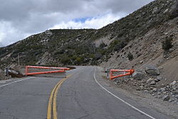
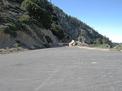
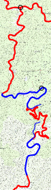
At the north limit of Azusa, adopted Route 39 begins again as San Gabriel Canyon Road. Route 39 winds through the San Gabriel Mountains in the Angeles National Forest for 21.9 miles (35.2 km) until it reaches a gate barring the road 1.8 miles (2.9 km) north of Crystal Lake Road in the Crystal Lake Recreation Area. The last four and one-half miles of the route, including the connection to Route 2, are closed to public highway traffic, as the roadbed has been closed since 1978, due to major rockslides in 1978, and again in 2005 which damaged more of the remaining roadbed. The segment connecting the Crystal Lake Recreation Area to Route 2 is not scheduled to reopen before 2015.[6]
A replacement of the section north of East Fork Road, in the next canyon to the east, was partly built in 1936 and 1961, but was never completed. The section includes one bridge and two tunnels; it was never used by automobile or truck traffic. In one local hiking guide the section is identified as the "Road to Nowhere" and the "Convict Road", although the official name is the Shoemaker Road and was planned to be an escape route in times of nuclear warfare[7]. A ca. 1967[8] replacement, much closer to the existing alignment, was also stopped prematurely, and so the middle of the segment between East Fork Road and the closure gate, with its many hairpin curves, still exists.
History
Prior to the present before reaching Harbor Boulevard, SR 39 continued north from Whittier Boulevard along Hacienda Road to the Los Angeles/Orange County line then north on Hacienda Boulevard and Glendora Avenue to US 60, 70, and 99 now Interstate 10 in West Covina. It then continued east with US 60, 70, and 99 to Azusa Avenue where it turned north to follow the present alignment as described in the following paragraph. The Hacienda Glendora segment can still be seen as Route 39 on some maps.
Prior to 1991, Harbor Boulevard would become Fullerton Road heading northward at the Los Angeles/Orange County Line, and would continue north as Fullerton Road though the Puente Hills as a one-lane winding road into Rowland Heights. However, due to complaints of nearby residents due to the increased volume of traffic, a straighter, wider stub was built slightly to the east, and was named Harbor Boulevard.
The new Harbor Boulevard became opened to the public early in 1992 and now serves as the primary passage between Orange County and Rowland Heights. The original winding Fullerton Road segment still exists but no longer serves as the primary passage. It is now strictly a residential street.
On July 10, 2006, the Pasadena Star-News reported that the state provided funding for an Environmental Impact Report (EIR) in June 2006 to assess the feasibility of reopening Highway 39 in the Angeles National Forest.
A 6.1-mile (9.8 km) stretch of the road, from Snow Springs north of Azusa to Highway 2, has been closed to the public since 1978 due to a massive rock and mudslide caused by heavy rains and floods. The EIR will take three years to complete, according to California Department of Transportation (Caltrans) officials.
The highway was opened to emergency crews in February 2003 after a Caltrans study showed reopening it would not harm wetlands, air and water quality, natural vegetation or threatened plants and animals. The proposed State Route 39 Roadway Rehabilitation Project would begin five miles (8 km) north of Crystal Lake Recreation Area Campground. In 2003, Caltrans officials estimated the project would cost $26.5 million.[citation needed]
According to the Caltrans District Seven "Inside Seven" newsletter, work will continue through 2009 and 2010 on reconstruction and installation of features to prevent future slides from damaging the roadway:
"Two projects that will address those issues and get the highway reopened are scheduled for construction soon. The first, building two retaining walls near the city of Azusa from Old San Gabriel Canyon Road to approximately four miles south of SR-2, could begin in mid-2009. The second, a $45 million project to reconstruct the roadway, construct soldier pile retaining walls, repair drainage systems, install rock fall protection, and provide asphalt concrete overlay and traffic striping, should begin in fall 2010."(source)
People heading to Mount Waterman must now travel west to Pasadena and join the Angeles Crest Highway (Highway 2) in La Canada Flintridge - a nearly two-hour trip. Reopening Highway 39 would cut the drive-time to the Waterman ski area in half and shorten the trip east to Wrightwood.
Major intersections
- Note: Except where prefixed with a letter, postmiles were measured in 1964, based on the alignment as it existed at that time, and do not necessarily reflect current mileage. The numbers reset at county lines; the start and end postmiles in each county are given in the county column.
County Location Postmile
[2][9][10][11]Destinations Notes Orange
ORA 0.00-22.66Huntington Beach 0.00 SR 1 (Pacific Coast Highway) – Laguna Beach, San Diego, Long BeachFormer US 101 Alt. 1.63 Adams Avenue 3.12 Main Street, Ellis Avenue 4.63 Warner Avenue 5.80  I-405 (San Diego Freeway) – San Diego, Long Beach
Interchange; former SR 7 Westminster 6.63 Bolsa Avenue 7.63 Westminster Avenue – Seal Beach 8.48  SR 22 (Garden Grove Freeway) – Long Beach, Orange
Interchange Garden Grove Garden Grove Boulevard – Santa Ana, Long Beach Former SR 22 Stanton 9.67 Chapman Avenue 10.66 Katella Avenue 11.18 Cerritos Avenue Anaheim 11.68 Ball Road 12.69 Lincoln Avenue Former SR 214 Buena Park 13.76 La Palma Avenue 14.38  SR 91 (Artesia Freeway) – Riverside
Interchange 14.58 Orangethrope Avenue 15.07 I-5 (Santa Ana Freeway) – Los Angeles, Santa AnaInterchange 15.15 Auto Center Drive (Manchester Boulevard) Former US 101 / SR 14 15.57 Artesia Boulevard 16.13 Stage Road Former SR 26 16.38  CR N8 (La Mirada Boulevard), Malvern Avenue
La Habra 19.17 SR 90 (Imperial Highway)19.67 Lambert Road 20.72  SR 72 (Whittier Boulevard)
20.88 Hacienda Road – La Puente, West Covina Former SR 39 north 22.66 Harbor Boulevard Former SR 72 south Gap in SR 39 Los Angeles
LA 10.70-44.40West Covina Cameron Avenue 10.71 I-10 (San Bernardino Freeway) – San Bernardino, Los AngelesInterchange 11.68 Badillo Street North end of state maintenance Azusa 13.10 Arrow Highway 13.62 North end of state maintenance 14.05  I-210 (Foothill Freeway) – San Bernardino, Pasadena
Interchange 14.95 Foothill Boulevard Former US 66 17.81 South end of state maintenance 39.90 Gate (closed north of here) Islip Saddle 44.40 SR 2 (Angeles Crest Highway)Closed 1.000 mi = 1.609 km; 1.000 km = 0.621 mi
Concurrency terminus • Closed/Former • Incomplete access • UnopenedReferences
- ^ California Highways: State Route 39
- ^ a b California Department of Transportation, State Truck Route List (XLS file), accessed January 2008
- ^ CA Codes (shc:250-257)
- ^ CA Codes (shc:260-284)
- ^ "Officially Designated State Scenic Highways and Historic Parkways". California Department of Transportation. December 7, 2007. http://www.dot.ca.gov/hq/LandArch/scenic_highways/. Retrieved June 22, 2011.
- ^ http://www.pasadenastarnews.com/news/ci_16117897?source=rss_viewed
- ^ http://www.wejc.com/photo_gallery/the_convict_road.htm
- ^ January 1, 2006 California Log of Bridges on State Highways
- ^ California Department of Transportation, Log of Bridges on State Highways, July 2007
- ^ California Department of Transportation, All Traffic Volumes on CSHS, 2006
- ^ California Department of Transportation, All Traffic Volumes on CSHS, 1996 (the last year before it was updated to remove the relinquished part)
External links
Categories:- State highways in California
- Scenic highways in California
- Roads in Orange County, California
- Roads in Los Angeles County, California
- Angeles National Forest


Wikimedia Foundation. 2010.