- Dungannon and South Tyrone Borough Council
-
Coordinates: 54°25′30″N 7°05′46″W / 54.425°N 7.096°W
Dungannon and South Tyrone Borough Council Geography 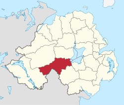
Area
- TotalRanked 5th of 26
315[1] km²Admin HQ Dungannon ISO 3166-2 GB-DGN ONS code 95M Demographics Population
- Total (2010)
- DensityRanked
/ km²Community Catholic: 60.8%
Protestant: 38.2%Politics Control No overall control
Sinn Féin: 8
DUP: 6
UUP: 4
SDLP: 3
Éirígí: 1MLAs Fermanagh & South Tyrone & Mid Ulster
Sinn Féin: 6
DUP: 1
SDLP: 1
UUP: 2MPs Michelle Gildernew (Sinn Féin)
Martin McGuinness (Sinn Féin)Meeting place Website http://www.dungannon.gov.uk Dungannon and South Tyrone Borough Council (Irish: Comhairle Buirge Dhún Geanainn agus Thír Eoghain Theas, Ulster Scots: Rathgannon an Sooth Owenslann Burgh Cooncil)[2] is a local council in Northern Ireland. Its main town is Dungannon, where the council is headquartered. The council area covers the southern part of County Tyrone (along with a small area of County Armagh) and has a population of nearly 48,000. Apart from Dungannon there are many smaller towns including: Augher, Clogher, Fivemiletown, Ballygawley, Caledon, Aughnacloy, Benburb, Moy and Coalisland.
The district was originally named Dungannon, and took its present name on November 25, 1999, after petitioning the Secretary of State for the Environment.
The Dungannon and South Tyrone Council area consists of four electoral areas: Blackwater, Clogher Valley, Dungannon Town and Torrent. In the 2005 elections, 22 members were elected from the following political parties: 8 Sinn Féin, 5 Democratic Unionist Party (DUP), 4 Ulster Unionist Party (UUP) 4 Social Democratic and Labour Party (SDLP) and 1 Éirígí (EIR). The Council adopted the d'Hondt system in 2001 which allows the position of Mayor and Deputy Mayor to be allocated according to party size. The current mayor is Councillor Michelle O'Neill (SF) and the Deputy Mayor is Councillor Norman Badger (UUP).
In elections for the Westminster Parliament it is split between the Mid-Ulster and Fermanagh & South Tyrone constituencies.
Contents
Review of Public Administration
Under the Review of Public Administration (RPA) the council is due to merge with Magherafelt District Council and Cookstown District Council in 2011 to form a single council for the enlarged area totalling 1714 km² and a population of 120, 096.[3] The next election was due to take place in May 2009, but on April 25, 2008, Shaun Woodward, Secretary of State for Northern Ireland announced that the scheduled 2009 district council elections were to be postponed until the introduction of the eleven new councils in 2011.[4]
See also
References
- ^ http://www.dungannon.gov.uk/pubuploads/Profile%20&%20Statistics.doc
- ^ Dungannon & South Tyrone Borough Council
- ^ "Minister Foster announces decisions on Local Government Reform". DoE. http://www.doeni.gov.uk/index/local_government/minister_foster_announces_decisions_on_local_government_reform.htm. Retrieved 2008-05-31.
- ^ Northern Ireland elections are postponed, BBC News, April 25, 2008, accessed April 27, 2008
External links
Local authorities of Northern Ireland Antrim · Ards · Armagh · Ballymena · Ballymoney · Banbridge · Belfast · Carrickfergus · Castlereagh · Coleraine · Cookstown · Craigavon · Derry · Down · Dungannon and South Tyrone · Fermanagh · Larne · Limavady · Lisburn · Magherafelt · Moyle · Newry and Mourne · Newtownabbey · North Down · Omagh · Strabane
Categories:- Politics of County Tyrone
- Dungannon
- Local authorities of Northern Ireland

Wikimedia Foundation. 2010.