- Fivemiletown
Infobox Irish Place|thumb|left|name = Fivemiletown
irish = Baile an Lorgan
scots =
map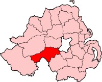
pin coords =
north coord =
west coord =
province =Ulster
county =County Tyrone
NI district = Dungannon
UK constituency = Fermanagh and South Tyrone
stdcode = 028, +44 28
posttown = Fivemiletown
postcode = BT75
population = 1108
census yr = 2001
web = www.dungannon.gov.ukFivemiletown ("Baile an Lorgan" in Irish) is a
village inCounty Tyrone ,Northern Ireland . It is situated 16 miles (26 km) east ofEnniskillen ,County Fermanagh and 26 miles (42 km) west-southwest ofDungannon , on the A4Belfast to Enniskillen road, close to the county boundary with Fermanagh. Fivemiletown's English-language name derives from its location five Irish miles (1 Irish mile = 2,240yd / 2048 m) from its nearest neighbours:Clogher ,Brookeborough , and Tempo. The United Kingdom Census of 2001 recorded a population of 1,108.The village is most famous for its creamery, which was established as a co-operative in 1898 by H.D. Fellonburg Montgomery. Fivemiletown Creamery originally produced butter and milk, but now exports speciality cheeses across
Europe andNorth America .History
The Troubles Incidents in Fivemiletown during the Troubles resulting in two or more fatalities:
1993
*12 December 1993 - Andrew Beacom (46) and Ernest Smith (49), both Protestant members of theRoyal Ulster Constabulary , were shot dead by theProvisional Irish Republican Army while travelling in their civilian-type car, Main Street, Fivemiletown.Transport
The narrow gauge
Clogher Valley Railway ran through the village from 1887 until 1942. The train originally had a top speed of 10 mph (16 km/h). Fivemiletown railway station opened on2 May 1887 and finally closed on1 January 1942 . [cite web | title=Fivemiletown station | work=Railscot - Irish Railways | url=http://www.railscot.co.uk/Ireland/Irish_railways.pdf | accessdate=2007-10-14]Education
*
Fivemiletown High School and Community College
*Fivemiletown Primary School
*St. Mary's Primary School2001 Census
Fivemiletown is classified as a village by the [http://www.nisra.gov.uk/ NI Statistics and Research Agency (NISRA)] (ie with population between 1,000 and 2,250 people). On Census day (
29 April 2001 ) there were 1,108 people living in Fivemiletown. Of these:
*19.9% were aged under 16 and 20.6% were aged 60 and over
*48.4% of the population were male and 51.6% were female
*25.1% were from aCatholic background and 74.0% were from a Protestant background
*5.6% of people aged 16-74 were unemployed.For more details see: [http://www.ninis.nisra.gov.uk/ NI Neighbourhood Information Service]
See also
*
List of villages in Northern Ireland
*List of towns in Northern Ireland References
*Dungannon & South Tyrone Area Plan 2010
External links
* [http://cloghmore.bravepages.com/fermanagh/fivemiletownrailway.html Fivemiletown Railway Station]
Wikimedia Foundation. 2010.