- Newtownabbey Borough Council
-
Newtownabbey Borough Geography 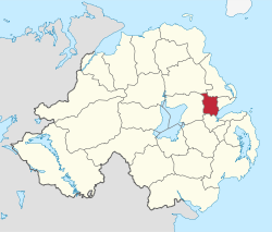
Area
- TotalRanked 22nd of 26
151 km²Admin HQ Newtownabbey ISO 3166-2 GB-NTA ONS code 95U Demographics Population
- Total (2010)
- DensityRanked 6th
83,600
555 / km²Community Catholic: 19.4%
Protestant: 76.2%Politics Control No overall control
DUP: 12
Alliance Party: 5
UUP: 5
Sinn Féin: 2
SDLP: 1MLAs Belfast North, East Antrim & South Antrim
DUP: 9
Sinn Féin: 4
SDLP: 1
UUP: 2
Alliance Party: 2MPs Nigel Dodds (DUP)
William McCrea (DUP)
Sammy Wilson (DUP)Meeting place 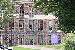 Newtownabbey Borough Council Headquarters, Mossley Mill
Website http://www.newtownabbey.gov.uk Newtownabbey Borough Council is a Local Council in County Antrim in Northern Ireland. Newtownabbey has a population of over 80,000 and is on the north shore of Belfast Lough just immediately north of Belfast. The Borough was founded in 1958 as a result of an Act of Parliament passed in 1957 and comprises large urban residential areas along with traditional farming communities. Its major industries include electronics, software and telecommunications development and agriculture. Council headquarters are at Mossley Mill in Newtownabbey. Towns within the area include Ballyclare and Glengormley. The University of Ulster at Jordanstown is also in the Council area.
The Newtownabbey Borough Council area consists of 4 electoral areas: Antrim Line, Macedon, University and Ballyclare. At the 2011 elections 25 members were elected from the following political parties: 12 Democratic Unionist Party (DUP), 5 Ulster Unionist Party (UUP), 5 Alliance Party, 1 Social Democratic and Labour Party (SDLP), and 2 Sinn Féin. At the Annual General Meeting of the Council on the first Monday in June each year the Mayor is elected and becomes the first citizen of the Borough. The Mayor of Newtownabbey for 2011/2012 is Alderman Billy Wedd (Alliance Party of Northern Ireland) and the Deputy Mayor is Alderman Victor Robinson (DUP).[1]
In elections for the Westminster Parliament it is split between the East Antrim constituency, the South Antrim constituency and the North Belfast constituency.
- See Also: Local Councils in Northern Ireland
Contents
2011 Election results
Party seats change +/- • Democratic Unionist Party 12 = • Ulster Unionist Party 5 -1 • Alliance Party of Northern Ireland 5 +3 • Sinn Féin 2 +1 • Social Democratic and Labour Party 1 = • Newtownabbey Ratepayers Association 0 -1 • United Unionist Coalition 0 -1 • Independent 0 -1 2005 Election results
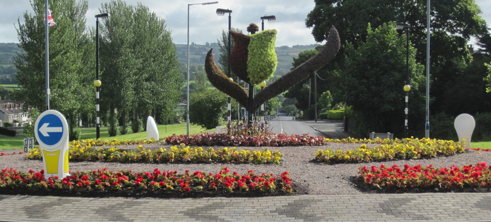
Party seats change +/- • Democratic Unionist Party 12 +4 • Ulster Unionist Party 6 -3 • Alliance Party of Northern Ireland 2 +1 • Sinn Féin 1 = • Social Democratic and Labour Party 1 -1 • Newtownabbey Ratepayers Association 1 = • United Unionist Coalition 1 = • Independent 1 -1 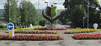 Floral sculpture on a roundabout in the borough showing a 3D representation of Newtownabbey Borough Council's logo
Mayors
- 1977 - 78: S. R. Cameron
- 1986 - 87: George Herron, Ulster Unionist Party
- 1990 - 91: Fraser Agnew, Ulster Unionist Party
- 1991 - 92: Ken Robinson, Ulster Unionist Party
- 1996 - 97: Billy Snoddy, Democratic Unionist Party
- 1999 - 00: Jim Bingham, Ulster Unionist Party
- 2000 - 02: Vera McWilliam, Ulster Unionist Party
- 2002 - 04: Paul Girvan, Democratic Unionist Party
- 2004 - 05: Ted Turkington, Ulster Unionist Party
- 2005 - 06: Billy DeCourcy, Democratic Unionist Party
- 2006 - 07: Lynn Frazer, Alliance Party of Northern Ireland
- 2007 - 08: Nigel Hamilton, Democratic Unionist Party
- 2008 - 09: Victor Robinson, Democratic Unionist Party
- 2009 - 10: John Scott, Ulster Unionist Party
- 2010 - 11: Paula Bradley, Democratic Unionist Party
- 2011 - 12: Billy Webb, Alliance Party of Northern Ireland
Review of Public Administration
Under the Review of Public Administration (RPA) the district was due to merge with Antrim Borough in 2011 to form a single council for the enlarged area totalling 572 km² and a population of 128,361.[2] The next election was due to take place in May 2009, but on April 25, 2008, Shaun Woodward, Secretary of State for Northern Ireland announced that the scheduled 2009 district council elections were to be postponed until the introduction of the eleven new councils in 2011.[3]
References
- ^ "Mayor's Office". Newtownabbey Borough Council. http://www.newtownabbey.gov.uk/council.asp?cat=Council&css=normal. Retrieved 2008-05-31.
- ^ "Minister Foster announces decisions on Local Government Reform". DoE. http://www.doeni.gov.uk/index/local_government/minister_foster_announces_decisions_on_local_government_reform.htm. Retrieved 2008-05-31.
- ^ Northern Ireland elections are postponed, BBC News, April 25, 2008, accessed April 27, 2008
External links
Local authorities of Northern Ireland Antrim · Ards · Armagh · Ballymena · Ballymoney · Banbridge · Belfast · Carrickfergus · Castlereagh · Coleraine · Cookstown · Craigavon · Derry · Down · Dungannon and South Tyrone · Fermanagh · Larne · Limavady · Lisburn · Magherafelt · Moyle · Newry and Mourne · Newtownabbey · North Down · Omagh · Strabane
Categories:- Politics of County Antrim
- Local authorities of Northern Ireland


Wikimedia Foundation. 2010.