- Down District Council
-
Coordinates: 54°21′07″N 5°43′52″W / 54.352°N 5.731°W
Down District 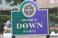
Sign bearing Down District Council logoGeography 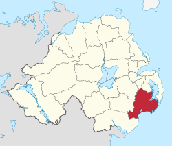
Area
- TotalRanked 7th of 26
647 km²Admin HQ Downpatrick ISO 3166-2 GB-DOW ONS code 95R Demographics Population
- Total (2010)
- DensityRanked 9th
70,800
109 / km²Community Catholic: 62%
Protestant: 34%Politics Control No overall control
SDLP: 9
Sinn Féin: 5
DUP: 3
UUP: 3
Alliance Party: 1
Green Party: 1
Independent: 1MLAs South Down & Strangford
DUP: 4
UUP: 3
Sinn Féin: 2
SDLP: 2
Alliance Party: 1MPs Margaret Ritchie (SDLP)
Jim Shannon (DUP)Meeting place Website http://www.downdc.gov.uk Down District Council is a Local Council in County Down in Northern Ireland. The Council is headquartered in Downpatrick. Other towns in the Council area are Ardglass, Ballynahinch, Castlewellan, Clough, Crossgar, Dundrum, Killough, Killyleagh, Newcastle, Saintfield, Seaforde and Strangford. It covers a population of nearly 64,000.
The Down District Council area consists of 4 electoral areas: Ballynahinch, Downpatrick, Newcastle and Rowallane. At the last election in 2005 23 Councillors were elected from the following political parties: 10 Social Democratic and Labour Party (SDLP), 5 Sinn Féin, 4 Ulster Unionist Party (UUP), 3 Democratic Unionist Party (DUP) and 1 Green Party. One of the UUP councillors has since defected to the Conservative Party. The current Council Chairman is Councillor Colin McGrath (SDLP) and the Vice Chair is Councillor William Dick (DUP).
In elections for the Westminster Parliament it is split between the Strangford constituency and the South Down constituency.
Contents
Work of the Council
The Council has periodically had to provide funding to ensure that the Saint Patrick Visitor Centre in Downpatrick remains in operation. It has also funded a major promenade infrastructure regeneration in Newcastle. The new promenade has won a number of National awards including a Civic Trust Award for Excellence in the Public Realm.
Review of Public Administration
Under the Review of Public Administration (RPA) the Council is due to merge with Newry and Mourne District Council in 2011 to form a single council for the enlarged area totalling 1539 km² and a population of 150,886.[1] The next election was due to take place in May 2009, but on April 25, 2008, Shaun Woodward, Secretary of State for Northern Ireland announced that the scheduled 2009 district council elections were to be postponed until the introduction of the eleven new councils in 2011.[2]
See also
- Local Councils in Northern Ireland
References
- ^ "Minister Foster announces decisions on Local Government Reform". DoE. http://www.doeni.gov.uk/index/local_government/minister_foster_announces_decisions_on_local_government_reform.htm. Retrieved 2008-05-31.
- ^ Northern Ireland elections are postponed, BBC News, April 25, 2008, accessed April 27, 2008
External links
Local authorities of Northern Ireland Antrim · Ards · Armagh · Ballymena · Ballymoney · Banbridge · Belfast · Carrickfergus · Castlereagh · Coleraine · Cookstown · Craigavon · Derry · Down · Dungannon and South Tyrone · Fermanagh · Larne · Limavady · Lisburn · Magherafelt · Moyle · Newry and Mourne · Newtownabbey · North Down · Omagh · Strabane
Categories:- Politics of County Down
- Downpatrick
- Local authorities of Northern Ireland


Wikimedia Foundation. 2010.