- Robert Moses Causeway
-
This article is about the Long Island causeway. For the Niagara Falls parkway, see Robert Moses State Parkway.
Robert Moses Causeway
Route information Length: 8.10 mi[1] (13.04 km) Existed: 1951(completed 1964) – present Major junctions South end: Robert Moses State Park on Fire Island  Ocean Parkway in Captree State Park
 NY 27 in West Islip
North end:  Southern State Parkway in West Islip
Location Counties: Suffolk Highway system Numbered highways in New York
Interstate • U.S. • N.Y. (former) • Reference • CountyThe Robert Moses Causeway is an 8.10-mile (13.04 km) long parkway in Suffolk County, New York. The parkway, originally known as the Captree Causeway, connects West Islip on Long Island to the barrier beach islands, such as Captree Island, Jones Beach Island, and the western tip of Fire Island, to the south. It is designated New York State Route 908J, an unsigned reference route. The road, like most parkways in New York State, is limited to non-commercial traffic, except south of NY 27A.
Contents
Route description
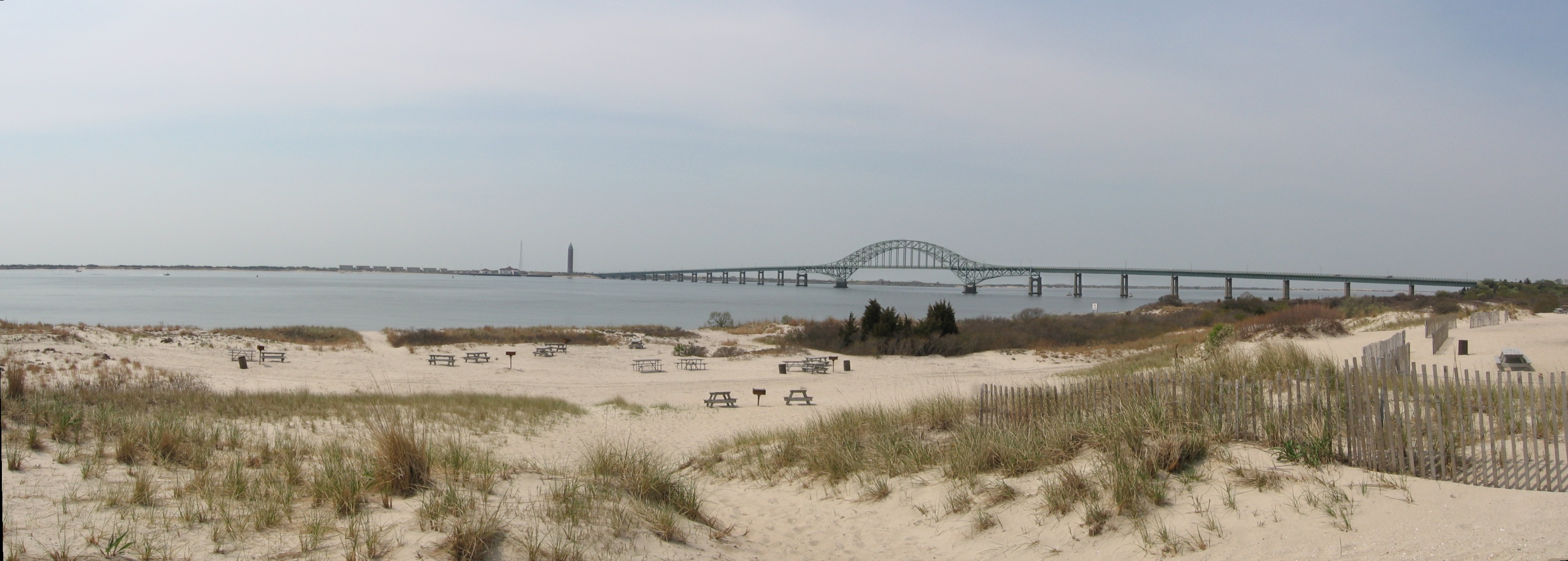
 The Fire Island Inlet Bridge carrying the causeway over the Fire Island Inlet as seen from Captree State Park.
The Fire Island Inlet span of the Robert Moses Causeway connects to Robert Moses State Park on the western tip of Fire Island. From here the road changes from a two-lane undivided highway into a four-lane undivided highway as it crosses over a cloverleaf interchange with Ocean Parkway, where it becomes a five-lane divided highway with three northbound lanes and two southbound lanes. The parkway then traverses the State Boat Channel Bridge by way of a 665-foot (203 m)-long bascule bridge modeled after the Mill Basin Drawbridge in Mill Basin, Brooklyn. The north foot of the bridge contains an unnumbered interchange to a private road on Captree Island, where the rest of the road is surrounded by protected land. On the section that crosses over the Great South Bay, via the Great South Bay Bridge, the New York City skyline can be faintly seen—on a clear day. Originally a toll bridge, the remnants of the former toll plaza for the Great South Bay Bridge can be found at the north side in West Islip. At the cloverleaf interchange with New York State Route 27A, the third northbound lane becomes the deceleration ramp, and from there the rest of the parkway is four lanes wide.
The parkway soon takes a slight northeastern turn and later rises to move over Union Boulevard (Suffolk CR 50) the Montauk Branch of the Long Island Rail Road, and Orinoco Drive with no access to either roads. Instead, another cloverleaf interchange is available at New York State Route 27, and the road remains elevated as it crosses over Muncey Road, and then runs along the west side of Casamento Park before approaching its northern terminus at the interchange with Southern State Parkway. The north-to-eastbound ramp to the Southern State (Heckscher) Parkway contains an interchange of its own with Suffolk CR 57 (Bay Shore Road). The other ramps exist on a partial cloverleaf just west of Bay Shore Road's interchange with the Southern State.
History
The first sprawling trestle crossing from West Islip to Captree Island was completed in 1951. The structure is 3,206.2 metres (2.0 mi) in length with a middle clearance for boats of 18.2 metres (59.7 ft).[2] Originally, one lane was for southbound traffic and the other for northbound traffic. In 1967, a new span was built next to the original bridge, carrying three lanes of northbound traffic.[2] The original bridge was reconfigured to carry southbound traffic.
The Fire Island Inlet span was completed in 1964 and by 1985 a dual span was supposed to be mimicked in order to alleviate traffic yet it was never done. When first proposed in 1938, the span was to be a vertical-lift span with a design similar to that of the Marine Parkway-Gil Hodges Memorial Bridge. Later, the design of the Fire Island Bridge was changed to conform with that of the Great South Bay span, a 600-foot (180 m) steel-arch span with a 60-foot (18 m) clearance.[3][4]
Future
In 2004, the New York State Department of Transportation began studies on the Fire Island Inlet span due to flaws in the cement used for its construction. Currently repairs are being undertaken to extend the life and safety of the bridge; groundbreaking for a new bridge is expected in 2010.[citation needed] It is assumed that the new bridge will be built to the west of the current structure; the new span will be four lanes, two southbound and two northbound.[citation needed] The new bridge is thought to retain the look of the old one for aesthetic conformity with the other bridges of the bay.[citation needed] After the new bridge is constructed, the original span will be removed but implosion is not thought to be the method of deconstruction. Instead it is more likely the bridge will be disassembled and removed by crane.
Exit list
The entire route is in Suffolk County.
Location Mile[1] Exit Destinations Notes Fire Island 0.00 Robert Moses State Park Traffic circle. Captree State Park 1.03 Ocean ParkwayCaptree Island Exit contains ramps for reversing direction on the Causeway. West Islip 5.25 RM2 E-W  NY 27A (Montauk Highway)
7.32 RM1 W-E NY 27 (Sunrise Highway)All trucks and buses must exit here going northbound. 8.10 Southern State Parkway west – New York CityNorthbound exit and southbound entrance  CR 57
CR 57Northbound exit and entrance, from north to eastbound ramp to Heckscher and Sagtikos State Parkways  Southern State Parkway east to Heckscher Parkway
Northbound exit and southbound entrance 1.000 mi = 1.609 km; 1.000 km = 0.621 mi References
- ^ a b "2007 Traffic Data Report for New York State" (PDF). New York State Department of Transportation. July 25, 2008. https://www.nysdot.gov/divisions/engineering/technical-services/hds-respository/NYSDOT_Traffic_Data_Report_2007.pdf. Retrieved July 17, 2009.
- ^ a b National Bridge Inventory, a database compiled by the United States Department of Transportation Federal Highway Administration, available at www.nationalbridges.com. Accessed August 29, 2007.
- ^ Maiorana, Ronald (June 14, 1964). "New L.I. Bridge Opened By Moses". The New York Times: p. 82. http://select.nytimes.com/gst/abstract.html?res=F20D10F73F581B728DDDAD0994DE405B848AF1D3. Retrieved April 11, 2010.
- ^ Anderson, Steve. "Robert Moses Causeway". NYCRoads. http://www.nycroads.com/roads/robert-moses/. Retrieved April 11, 2010.
External links
- Robert Moses Causeway Article from NYCROADS Web Site
- Interchange of the Week; Monday, March 19, 2001 (Empire State Roads)
- Captree State Park
- Robert Moses State Park
- Robert Moses Causeway (Greater New York Roads)
Parkways on Long Island, New York East-west North-south Formerly proposed Categories:- Parkways in New York
- Long Island highways
- Robert Moses projects
- Transportation in Suffolk County, New York

Wikimedia Foundation. 2010.