- Parkways in New York State
-
The New York State Parkway System opened its first section in 1908 and was a series of then-high speed (25 miles per hour (40 km/h)) four-lane roads that were created to provide a scenic way into, out of, and around New York City. The parkway system is still in use today. Most of the early roads have been replaced and redesigned to address higher speed requirements and to increase capacity.
The parkway system introduced the concept of limited-access roads.[1] These highways were not divided and allowed no driveway cuts, but did have intersections for some of the streets they crossed. A small section of the privately financed Long Island Motor Parkway was the first limited-access road to begin operation as a toll road[2] and the first highway to use bridges and overpasses to eliminate intersections.[3]
In later sections north of New York City, the road ways were typically divided by a wide landscaped median and provided service areas along the way that offered fuel and restrooms.[4] Many of these parkways were built by regional agencies such as the Long Island State Park Commission (LISPC), New York City Parks Department, Taconic State Park Commission (TSPC), Westchester County Parks Commission (WCPC), and Palisades Interstate Park Commission (PIPC).

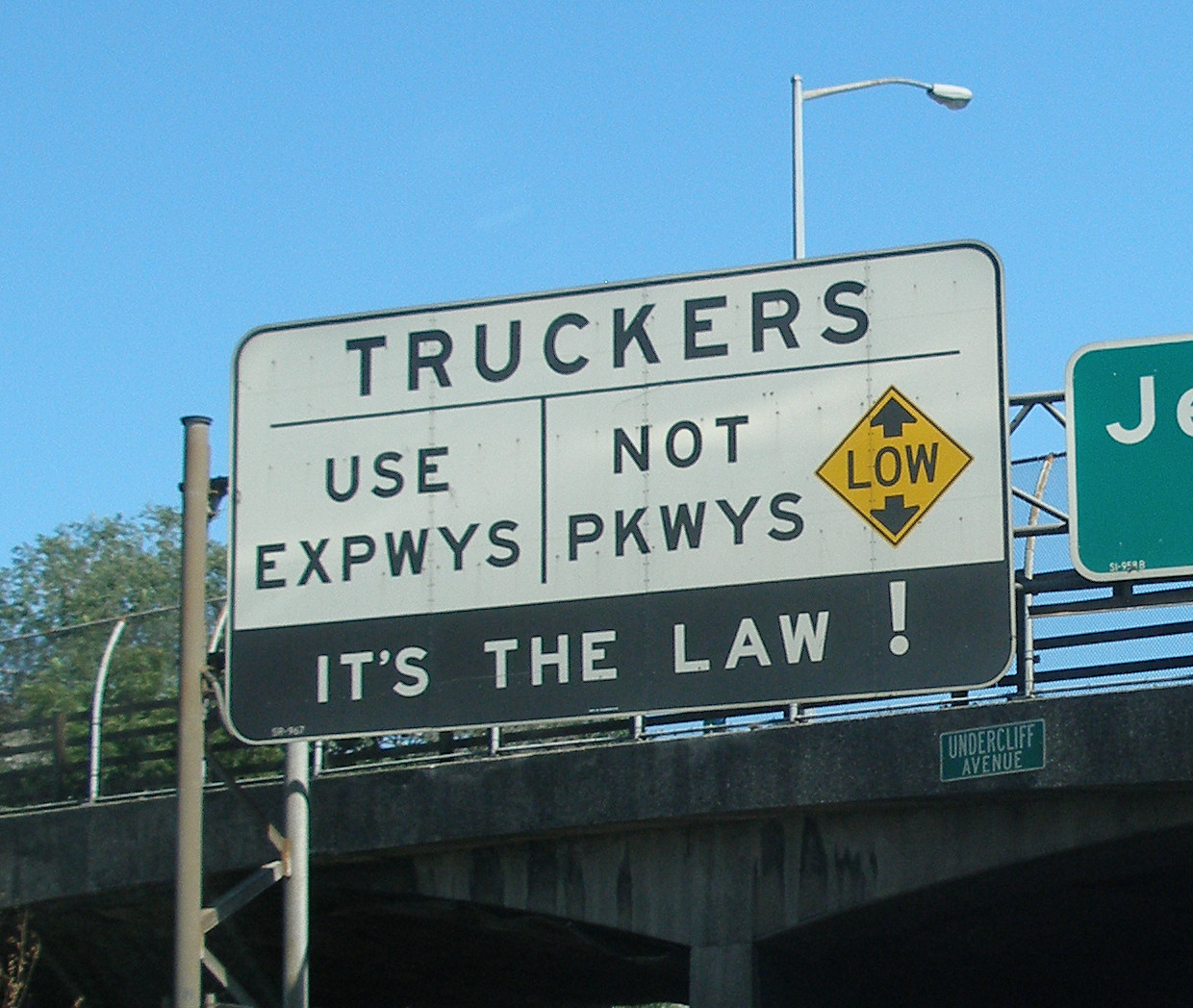
Today, Parkways are for the most part equivalent to expressways and freeways built in other parts of the country, except for a few oddities. First, because many of these roads were either designed before civil engineers had experience building roads for automobile use or widened in response to increasing traffic, many New York parkways lack shoulders. Second, because designers focused more on making routes scenic rather than efficient, the parkways are meandering, often built to follow a river, and so contain many turns. Finally, because most use low, decorative stone-arch overpasses that would trap trucks, commercial vehicles are banned from parkways. Because Manhattan island has only one short interstate passing through the far Upper West Side, this has led to the oddity of forcing all trucking in Manhattan onto local streets.
The Vanderbilt Parkway, an exception in western Suffolk County, is a surviving remnant of the Long Island Motor Parkway that became a surface street, no longer with controlled-access or non-commercial vehicle restrictions.
Contents
State parkways
In Western New York
 Lake Ontario State Parkway A parkway along the southern shore of Lake Ontario
 Robert Moses State Parkway A parkway in the Niagra Falls region
In the Adirondacks
 Prospect Mountain Veterans Memorial Highway A parkway going to the top of Prospect Mountain from US 9/NY 9N in Lake George
- Whiteface Mountain Veterans Memorial Highway A parkway going to the top of Whiteface Mountain from NY 86 in Wilmington
In the Hudson Valley
 Bear Mountain State Parkway (1932) A parkway near the Bear Mountain Bridge that goes from US6/9/202 in Peekskill to NY35/US202 in Cortlandt
 Bronx River Parkway (1908) A parkway parallel to the Bronx River from Story Avenue in the Bronx to the Kensico Circle in New Castle
 Cross County Parkway A parkway going from the Saw Mill River Parkway to the Hutchiston River Parkway in southern Westchester County
 Hutchinson River Parkway A parkway which passes by the Hutchinson River and connects the Bruckner Interchange in the Bronx with the Merritt Parkway at the New York-Connecticut border
 Lake Welch Parkway A parkway in Harriman State Park which connects Seven Lakes Drive with the Palisades Interstate Parkway
- Long Mountain Parkway A seven mile section of US6 from the border of Harriman State Park to the Palisades Interstate Parkway near Bear Mountain Circle
 Palisades Interstate Parkway A parkway passing by many important parks in the Palisades, connecting I-95 in New Jersey near the George Washington Bridge to US6, US9W and US202 at the Bear Mountain Circle near the Bear Mountain Bridge
 Saw Mill River Parkway (1954) A parkway parallel to the Saw Mill River from the Bronx-Westchester County border in Yonkers to I-684 and NY35 in Bedford
 Sprain Brook Parkway A parkway connecting the Bronx River Parkway in Yonkers with the Taconic State Parkway in Hawthorne
 Taconic State Parkway A parkway passing by many places in the Taconic region on its over 100-mile route
 Seven Lakes Drive A parkway passing by many places in Harriman State Park going from NY17 in Sloatsburg to US9W/202
In New York City
 Belt Parkway (1941)
 Bronx and Pelham Parkway
 Cross Island Parkway (1940)
 FDR Drive
 Grand Central Parkway (1936)
 Harlem River Drive
 Henry Hudson Parkway (1937)
 Jackie Robinson Parkway
 Korean War Veterans Parkway
 Mosholu Parkway
On Long Island
 Bay Parkway A parkway connecting the Wantagh and Meadowbrook Parkways with the western end of Jones Beach State Park
 Bethpage State Parkway A parkway connecting the Southern Parkway with Bethpage State Park
 Heckscher State Parkway (1959) A parkway connecting the Southern and Sagtikos Parkways with Heckscher State Park
 Loop Parkway A parkway connecting Jones Beach State Park with Lido Beach and Point Lookout
 Meadowbrook State Parkway (1932) A parkway connecting Nassau County with Jones Beach State Park
 Northern State Parkway (1965) A parkway connecting the Grand Central Parkway with points on eastern Long Island
 Ocean Parkway A parkway connecting all of the barrier beaches on Jones Beach Island, from Jones Beach State Park to Captree State Park
 Robert Moses Causeway A parkway connecting the Southern State Parkway with Captree State Park and Robert Moses State Park
 Sagtikos State Parkway (1952) A parkway connecting the Southern and Heckscher Parkways with the Long Island Expressway and the Northern Parkway
 Southern State Parkway (1949) A parkway connecting the Belt and Cross Island Parkways with points on eastern Long Island
 Sunken Meadow State Parkway (1957) A parkway connecting the Long Island Expressway and the Northern Parkway with Sunken Meadow State Park
 Wantagh State Parkway (1929) A parkway connecting Nassau County with Jones Beach State Park
County and local parkways
Besides those under NYSDOT jurisdiction, many other regions of New York have their own parkways. Westchester County, for example contains some that were originally part of the TSPC and WCPC, while Suffolk County has preserved a section of the former Vanderbilt Motor Parkway for current driving, and built their own roads on land originally reserved for the LISPC.
In Central New York
- Onondaga Lake Parkway
In the Hudson Valley
 Arden Valley Road (not named a Parkway, but a park road under PIPC jurisdiction)
- Central Westchester Parkway
- Farragut Parkway
- Long Mountain Parkway
- Playland Parkway
 Tiorati Brook Road (not named a Parkway, but a park road under PIPC jurisdiction)
On Long Island
 Vanderbilt Parkway/Long Island Motor Parkway
 William Floyd Parkway
 Fire Island Beach Road
References
External links
Categories:- Parkways in New York
Wikimedia Foundation. 2010.