- City Island Bridge
-
City Island Bridge 
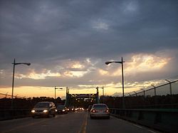
An off-going view of the City Island Bridge on a summer night in 2006.Carries 3 lanes of City Island Road Crosses Eastchester Bay Locale The Bronx and City Island in New York City Maintained by New York City Department of Transportation Design Swing bridge Material Steel and stone Total length 950 ft (290 m) Number of spans 7 Piers in water 6 Clearance below 8 ft (2.4 m) Construction begin 1899 Opened July 4, 1901[1] Daily traffic 15,955 (2008)[2] The City Island Bridge is a bridge in the New York City borough of the Bronx, connecting City Island and Rodman's Neck on the mainland. It is of stone and steel construction, and spans 950 ft (290 m). Construction was begun in 1899 and completed in 1901, at a cost of $200,000.[3] It consists of five fixed spans and a central swing section which was converted to fixed spans in 1963.
Planned replacement bridge
The city plans to demolish the bridge, due to its deteriorated condition, and replace it with a cable-stayed bridge. The current design calls for a 150 ft (46 m) high tower, 13 ft (4 m) wide at the top, with a base of 26 ft (8 m). Vertical clearance above high water would be 12 ft.[4] The new bridge would be located in the same footprint as the existing bridge, although it would be 17 ft (5.2 m) wider to accommodate three standard-width traffic lanes, a bicycle lane and a pedestrian walkway. The original schedule was for the project to begin in 2007 with completion in 2010, but the project is now scheduled to start in 2011.[5][6] As of 2005 the estimated cost of the project was $50 million.[7] As of 2009 the estimate increased to $120 million due to redesigns and the addition of related projects.[8]
Some residents oppose the design of the proposed bridge and feel that its tower would be out of character with the low-rise homes on City Island.[9]
References
- ^ "City Island Bridge Opened". The New York Times: p. 14. July 5, 1901. http://query.nytimes.com/gst/abstract.html?res=9D03E6DA143FE433A25756C0A9619C946097D6CF. Retrieved 2010-01-15.
- ^ "New York City Bridge Traffic Volumes 2008" (PDF). New York City Department of Transportation. March 2010. p. 110. http://www.nyc.gov/html/dot/downloads/pdf/bridgetrafrpt08.pdf. Retrieved 2010-06-27.
- ^ "The New City Island Bridge. Work Begun Yesterday on the $200,000 Steel and Stone Structure". The New York Times: p. 4. January 20, 1899. http://query.nytimes.com/gst/abstract.html?res=9C01E1D7163DE433A25753C2A9679C94689ED7CF. Retrieved 2009-08-15.
- ^ Dolensek, Barbara (April 2005). "Here Comes the Bridge". The Island Current (City Island). http://www.theislandcurrent.com/Island_Currents/12j-Is.%20Current%20April%202005.pdf. Retrieved 2009-09-11.
- ^ New York City Department of Transportation (NYCDOT)(2004). "2003 Bridges and Tunnels Annual Condition Report." p. 36. Accessed 2009-09-11.
- ^ NYCDOT (2009). "2008 Bridges and Tunnels Annual Condition Report." p. 111. Accessed 2009-09-11.
- ^ H. Perahia, L. King, K. Batra, S. Jarosz (2005). "City Island Cable-Stayed Bridge in New York City." Presented at the 3rd New York City Bridge Conference, New York, September 12–13, 2005.
- ^ Lombardi, Frank (May 11, 2009). "Span plan crosses $120M: 'Signature' City Island bridge plan's all wet, critics say". Daily News (New York). http://www.nydailynews.com/ny_local/2009/05/11/2009-05-11_span_plan_crosses_120m.html. Retrieved 2009-09-11.
- ^ Bindley, Katherine (November 14, 2008). "In the 'Nantucket of New York,' a Bridge to Agitation". The New York Times. http://www.nytimes.com/2008/11/16/nyregion/thecity/16brid.html. Retrieved 2009-08-15.
External links
Coordinates: 40°51′23″N 73°47′36″W / 40.856257°N 73.793291°W
Categories:- Bridges in New York City
- Bridges completed in 1901
- Buildings and structures in the Bronx
- Swing bridges in the United States
- Bike paths in New York
- Transportation in the Bronx
- Road bridges in New York
Wikimedia Foundation. 2010.
