- Washington Bridge
Infobox_Bridge
bridge_name= Washington Bridge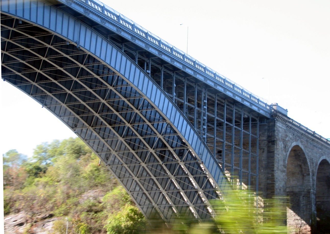
caption= TheManhattan side of the bridge.
official_name=
also_known_as=
carries= 6 lanes ofroadway and pedestrians
crosses=Harlem River
locale=Manhattan and TheBronx , inNew York City
maint=New York City Department of Transportation
id=
design=Arch bridge
mainspan= convert|510|ft|m
length= convert|2375|ft|m
width=
clearance= convert|134|ft|m
below=
traffic=
open=December 1 ,1888
closed=
toll=
map_cue=
map_
map_text=
map_width=
lat=
long=The Washington Bridge carries six lanes of traffic (plus sidewalks on both sides) over the
Harlem River inNew York City between the boroughs ofManhattan andthe Bronx , connecting 181st Street and Amsterdam Avenue in the Washington Heights section of Manhattan to University Avenue in the Bronx. Ramps at either end of the bridge connect to theTrans-Manhattan Expressway and theCross-Bronx Expressway . The bridge is operated and maintained by theNew York City Department of Transportation . It once carried U.S. Route 1, which now travels over theAlexander Hamilton Bridge .The total length of the bridge, including approaches, is convert|2375|ft|m. The parallel main spans of the steel arch bridge stretch convert|510|ft|m over the Harlem River, providing convert|134|ft|m of vertical clearance and convert|354|ft|m of horizontal clearance. The tidal maximum (mean higher high water) is convert|4.9|ft|m|abbr=on and extreme low water is -3.5 compared to mean lower low water.This two-hinged arch bridge was designed by William R. Hutton and
Edward H. Kendall , based on a design submitted by C. C. Schneider that was pared down to bring the bridge's cost to $3 million. The bridge features steel-arch construction with two 510-foot-long main spans and masonry approaches. The Washington Bridge opened to pedestrian traffic onDecember 1 ,1888 . The plan had been to open the bridge to vehicular traffic onFebruary 22 ,1889 —Washington's Birthday and the centennial anniversary of the first Presidency — but the full opening was delayed until December 1889.After completion of the
George Washington Bridge in 1931, traffic off the Bridge into the Bronx traveled over the Washington Bridge. Starting in the 1940s, ramps were built to connect the western end of the bridge to the 178th Street and 179th Street Tunnels leading to the George Washington Bridge. This allowed traffic to and from New Jersey to bypass the congested local streets of upper Manhattan.The
Alexander Hamilton Bridge was planned in the mid-1950s to provide a direct connection betweenRobert Moses ' proposed Trans-Manhattan andCross-Bronx Expressway s and to accommodate the additional traffic resulting from the addition of the six-lane lower level to the George Washington Bridge. The completion of the Alexander Hamilton Bridge in 1963 diverted much of the traffic away from the Washington Bridge.ee also
*
Andrew Haswell Green External links
* [http://www.nycroads.com/crossings/washington-heights/ NYC Roads: Washington Bridge]
* [http://www.nyc.gov/html/dot/home.html New York City Department of Transportation]
*
* [http://205.156.4.52/cgi-bin/EyeSpy.dll?getbrww&D:/EyeSpy/images/Online_Chart_Viewer/12342.axs&750&550&1216&3296&2&bgcolor=%23FFFFFF&buttons=/cgi-bin/EyeSpyResources/buttons&alig=0&contenttype=image/jpeg&375&275 Nautical Chart #12342]NOAA Crossings navbox
structure = Crossings
place =Harlem River
bridge = Washington Bridge
bridge signs =
upstream =University Heights Bridge
upstream signs =
downstream =Alexander Hamilton Bridge
downstream signs =

Wikimedia Foundation. 2010.