- Mount Erciyes
-
Mount Erciyes 
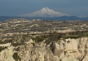
Distant view of Mount Erciyes, as seen from Cappadocia to the west.Elevation 3,916 m (12,848 ft) [1] Prominence 2,419 m (7,936 ft) [2] Listing Ultra Location Kayseri Province,  Turkey
Coordinates 38°31′12″N 35°28′48″E / 38.52°N 35.48°ECoordinates: 38°31′12″N 35°28′48″E / 38.52°N 35.48°E Geology Type Stratovolcano Last eruption 6880 BC ± 40 years[1] Mount Erciyes (Turkish: Erciyes Dağı; derived from the ancient Greek name Ἀργαῖος Argaeos; Latinized as Argaeus by the ancient Romans) is a massive stratovolcano located 25 km to the south of Kayseri in Turkey.
Erciyes is the highest mountain in central Anatolia, with its summit reaching 3,916 metres (12,848 ft). It is considered to be the highest peak of the Anti-Taurus mountain range, a northeastern extension of the Taurus Mountains to the south, and belongs to the Alpide belt in Eurasia.[3]
The volcano is heavily eroded, but may have erupted as recently as 253 BC, as may be depicted on Roman era coins.[4]
Strabo called the mountain Argaeus (Ἀργαῖος); he wrote that the summit was never free from snow and that those few who ascended it reported seeing both the Black Sea to the north and the Mediterranean Sea to the south in days with a clear sky.[5]
There are winter sports facilities on the mountain, which are usually accessed from nearby Kayseri.
Contents
Gallery
-
Satellite view of Mount Erciyes on 31 March 2005, NASA World Wind.
-
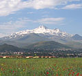
South side of Mount Erciyes as seen from Talas, Turkey.
See also
References
- ^ a b "Erciyes Dagi". Global Volcanism Program, Smithsonian Institution. http://www.volcano.si.edu/world/volcano.cfm?vnum=0103-01=. Retrieved 2010-03-23.
- ^ http://www.peaklist.org/WWlists/ultras/turkey.html
- ^ "Taurus Mountains". Encyclopædia Britannica. http://www.britannica.com/EBchecked/topic/584415/Taurus-Mountains. Retrieved 2010-04-28.
- ^ "Record 60952". acsearch.info. http://www.acsearch.info/record.html?id=60952. Retrieved 2010-04-13.
- ^ Strabo, Geographica 12.2.7.
External links
 Mountains of Turkey
Two main ranges Mountains Acıgöl • Akdağ • Aktaş • Ağrı (Ararat) • Babadağ • Beşparmak (Latmus) • Davraz • Dilek (Mycale) • Erciyes • Erek • Göllü • Hasan • Honaz • Kaçkar • Kadifekale • Karacadağ • Karadag • Karagöl • Kaz (Ida) • Kula • Küçük Ağrı • Madur • Mahya • Nemrut • Nemrut (volcano) • Nif • Palandöken • Spil • Sultan • Süphan • Şaphane • Tendürek • Topçambaba • Uludağ • Yamanlar • ZurbahanCategories:- Kayseri Province
- Mountains of Turkey
- Volcanoes of Turkey
- Stratovolcanoes
-
Wikimedia Foundation. 2010.


