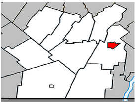
- Napierville, Quebec
-
Napierville, Quebec — Municipality — Location within Les Jardins-de-Napierville Regional County Municipality. Coordinates (260, rue de l'Église [1]): 45°11′23″N 73°24′10″W / 45.18972°N 73.40278°W Country  Canada
Province  Quebec
Region Montérégie RCM Les Jardins-de-Napierville Established January 1, 1873 Electoral Districts
FederalBeauharnois—Salaberry Provincial Huntingdon Government[1][2][3] – Mayor Alain Fredette – Federal MP(s) Anne Minh-Thu Quach (NDP) – Quebec MNA(s) Stéphane Billette (PLQ) Area[4] – Land 4.43 km2 (1.7 sq mi) Population (2006)[4] – Total 3,352 – Density 757.5/km2 (1,961.9/sq mi) – Change (2001-06)  9.1%
9.1%– Dwellings 1,334 Time zone EST (UTC-5) – Summer (DST) EDT (UTC-4) Postal code(s) J0J Area code(s) 450 Access Routes[5]  Route 219
 Route 221
Website www.napierville.ca Napierville is a municipality in the Jardins de Napierville Regional County Municipality in Quebec, Canada, situated in the Montérégie administrative region. The population as of the Canada 2006 Census was 3,352. It is the location of the seat of the Jardins de Napierville Regional County Municipality. It is completely surrounded by the municipality of Saint-Cyprien-de-Napierville.
Contents
Demographics
Population
Population trend[6]
Census Population Change (%) 2006 3,352  9.1%
9.1%2001 3,073  2.3%
2.3%1996 3,004  3.4%
3.4%1991 2,904 N/A Language
Mother tongue language (2006)[4]
Language Population Pct (%) French only 3,190 95.22% English only 90 2.69% Both English and French 40 1.19% Other languages 30 0.90% See also
References
- ^ a b Ministère des Affaires Municipales et Régions: Napierville
- ^ Parliament of Canada Federal Riding History: Beauharnois-Salaberry (Quebec)
- ^ Chief Electoral Officer of Québec - 40th General Election Riding Results: Huntingdon
- ^ a b c 2006 Statistics Canada Community Profile: Napierville, Quebec
- ^ Official Transport Quebec Road Map
- ^ Statistics Canada: 1996, 2001, 2006 census
External links

Saint-Cyprien-de-Napierville 
Saint-Cyprien-de-Napierville 
Saint-Cyprien-de-Napierville  Napierville

Saint-Cyprien-de-Napierville  Administrative divisions of Montérégie (Region 16)
Regional county municipalities
and equivalent territoriesBrome-Missisquoi · La Haute-Yamaska · Acton · Pierre-De Saurel · Les Maskoutains · Rouville · Le Haut-Richelieu · La Vallée-du-Richelieu · Longueuil · Marguerite-d'Youville · Roussillon · Les Jardins-de-Napierville · Le Haut-Saint-Laurent · Beauharnois-Salaberry · Vaudreuil-Soulanges
Municipalities Cowansville · Granby · Sorel-Tracy · Saint-Hyacinthe · Saint-Jean-sur-Richelieu · Chambly · Saint-Basile-le-Grand · Mont-Saint-Hilaire · Belœil · Brossard · Saint-Lambert · Boucherville · Saint-Bruno-de-Montarville · Longueuil · Sainte-Julie · Varennes · La Prairie · Candiac · Sainte-Catherine · Saint-Constant · Mercier · Châteauguay · Beauharnois · Salaberry-de-Valleyfield · Pincourt · Vaudreuil-Dorion · Saint-Lazare
Categories:- Municipalities in Quebec
- Incorporated places in Montérégie
- Montérégie geography stubs
Wikimedia Foundation. 2010.

