- Clay Township, Scioto County, Ohio
-
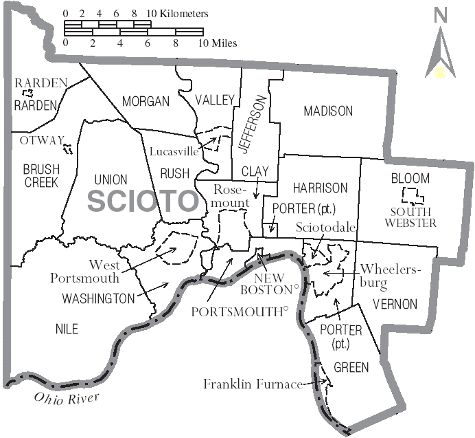
Clay Township, Scioto County, Ohio — Township — Municipalities and townships of Scioto County.
Coordinates: 38°47′32″N 82°58′6″W / 38.79222°N 82.96833°WCoordinates: 38°47′32″N 82°58′6″W / 38.79222°N 82.96833°W Country United States State Ohio County Scioto Area – Total 22.1 sq mi (57.3 km2) – Land 21.6 sq mi (56.1 km2) – Water 0.5 sq mi (1.3 km2) Elevation[1] 978 ft (298 m) Population (2000) – Total 3,792 – Density 175.2/sq mi (67.6/km2) Time zone Eastern (EST) (UTC-5) – Summer (DST) EDT (UTC-4) FIPS code 39-15560[2] GNIS feature ID 1086924[1] Clay Township is one of the sixteen townships of Scioto County, Ohio, United States. The 2000 census found 3,792 people in the township.[3]
Contents
Geography
Located in the center of the county, it borders the following townships:
- Valley Township - north, west of Jefferson Township
- Jefferson Township - north, east of Valley Township
- Harrison Township - east
- Porter Township - southeast
- Washington Township - southwest
- Rush Township - northwest
No municipalities are located in Clay Township, although the city of Portsmouth (the county seat of Scioto County) has incorporated much of the southern part of the township. The census-designated place of Rosemount lies in the center of the township, along with the unincorporated communities of Eden Park, Rubyville, and Twin Valley.
Name and history
It is one of nine Clay Townships statewide.[4]
Clay Township was organized on June 7, 1826.[5]
Government
The township is governed by a three-member board of trustees, who are elected in November of odd-numbered years to a four-year term beginning on the following January 1. Two are elected in the year after the presidential election and one is elected in the year before it. There is also an elected township fiscal officer,[6] who serves a four-year term beginning on April 1 of the year after the election, which is held in November of the year before the presidential election. Vacancies in the fiscal officership or on the board of trustees are filled by the remaining trustees.
The current township trustees are Jack Blevins, Tim Hines, and Howard Richard. Rick Vournazos is the township clerk.[7]
Public services
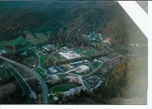 Aerial View of Clay High School and surrounding area near Feurt Hill Estates, fall of 2003
Residents are served by the Clay Local School District (Clay High School, Rubyville Elementary School, and Rosemount Primary School). The district is bordered by State Route 139 on the east and U.S. Route 23 and the Scioto River on the west. Volunteer fire departments are operated in the communities of Rosemount and Rubvyille.
References
- ^ a b "US Board on Geographic Names". United States Geological Survey. 2007-10-25. http://geonames.usgs.gov. Retrieved 2008-01-31.
- ^ "American FactFinder". United States Census Bureau. http://factfinder.census.gov. Retrieved 2008-01-31.
- ^ Scioto County, Ohio — Population by Places Estimates Ohio State University, 2007. Accessed 15 May 2007.
- ^ "Detailed map of Ohio" (PDF). United States Census Bureau. 2000. http://www2.census.gov/geo/maps/general_ref/cousub_outline/cen2k_pgsz/oh_cosub.pdf. Retrieved 2007-02-16.
- ^ "Portsmouth Area Resource Guide, 2007-2008". The Community Common. 2007-07-29. p. 6.
- ^ §503.24, §505.01, and §507.01 of the Ohio Revised Code. Accessed 4/30/2009.
- ^ Teresa Knittel, Director Board of Elections. "Scioto County Board of Elections". http://sites.google.com/site/sciotocountyboe/. Retrieved 2008-10-07.
External links
Municipalities and communities of Scioto County, Ohio City 
Villages New Boston | Otway | Rarden | South Webster
Townships CDPs Unincorporated
communitiesClarktown | Coles Park | Friendship | Haverhill | McDermott | Minford | Mule Town | Scioto Furnace
Categories:- Townships in Scioto County, Ohio


Wikimedia Foundation. 2010.