- Dryandra Woodland
-
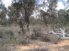
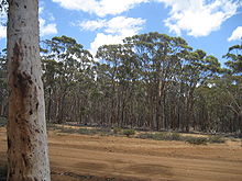
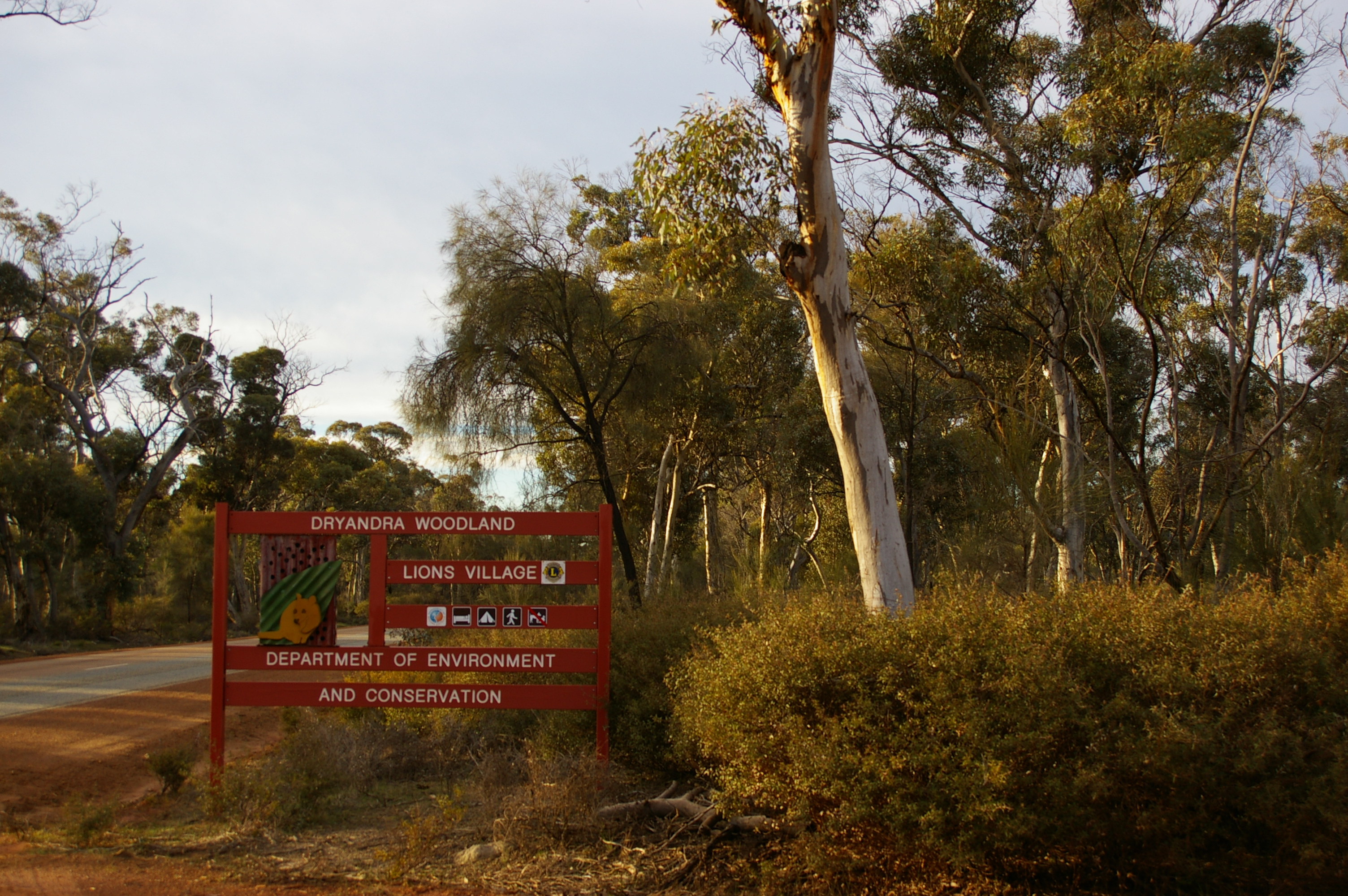
Dryandra Woodland Protected Area  Entrance to Dryandra Woodland on the Narrogin-Wandering road
Official name: Dryandra Woodland Name origin: Banksia ser. Dryandra Country Australia State Western Australia Region Wheatbelt (Western Australia) Coordinates 32°47′S 116°58′E / 32.783°S 116.967°E Area 280.66 km2 (108 sq mi) Founded 1976 For public Yes Website: Department of Environment and Conservation The Dryandra Woodland is a nature conservation area in Western Australia within the Shires of Cuballing, Williams and Wandering, about 164 kilometres (102 mi) south-east of Perth and 22 kilometres (14 mi) north-west of the town of Narrogin. It is a complex of 17 distinct blocks managed by the Western Australian Department of Environment and Conservation and spread over approximately 50 kilometres (30 mi) separated by areas of agricultural land. The area is considered to be one of the state's major conservation areas, and although it is far from pristine due to its history of logging operations, a number of species of threatened fauna are rebuilding populations through the removal of introduced predators such as foxes and feral cats.
The combined area of the Woodland is 28,066 hectares (108.36 mi²), with individual blocks ranging in size from 87 hectares (0.34 mi²) to 12,283 hectares (47.43 mi²).[1][2] Part of Dryandra Woodland is listed on the Register of the National Estate by the Australian Heritage Council.[3]
In addition to the area's use as a wildlife refuge, it has anthropological significance with the indigenous Noongar people having strong cultural links there.[4]
Contents
Description
 Typical heath in non-replanted areas of Dryandra Woodland
 Dryandra Woodland logo
The Dryandra Woodland is found within the south-western province of the Yilgarn craton, "an ancient plateau composed mainly of granite, with intrusions of dolerite and capped with laterite. Past weathering of the plateau in the Dryandra area has produced a gently undulating countryside".[1]
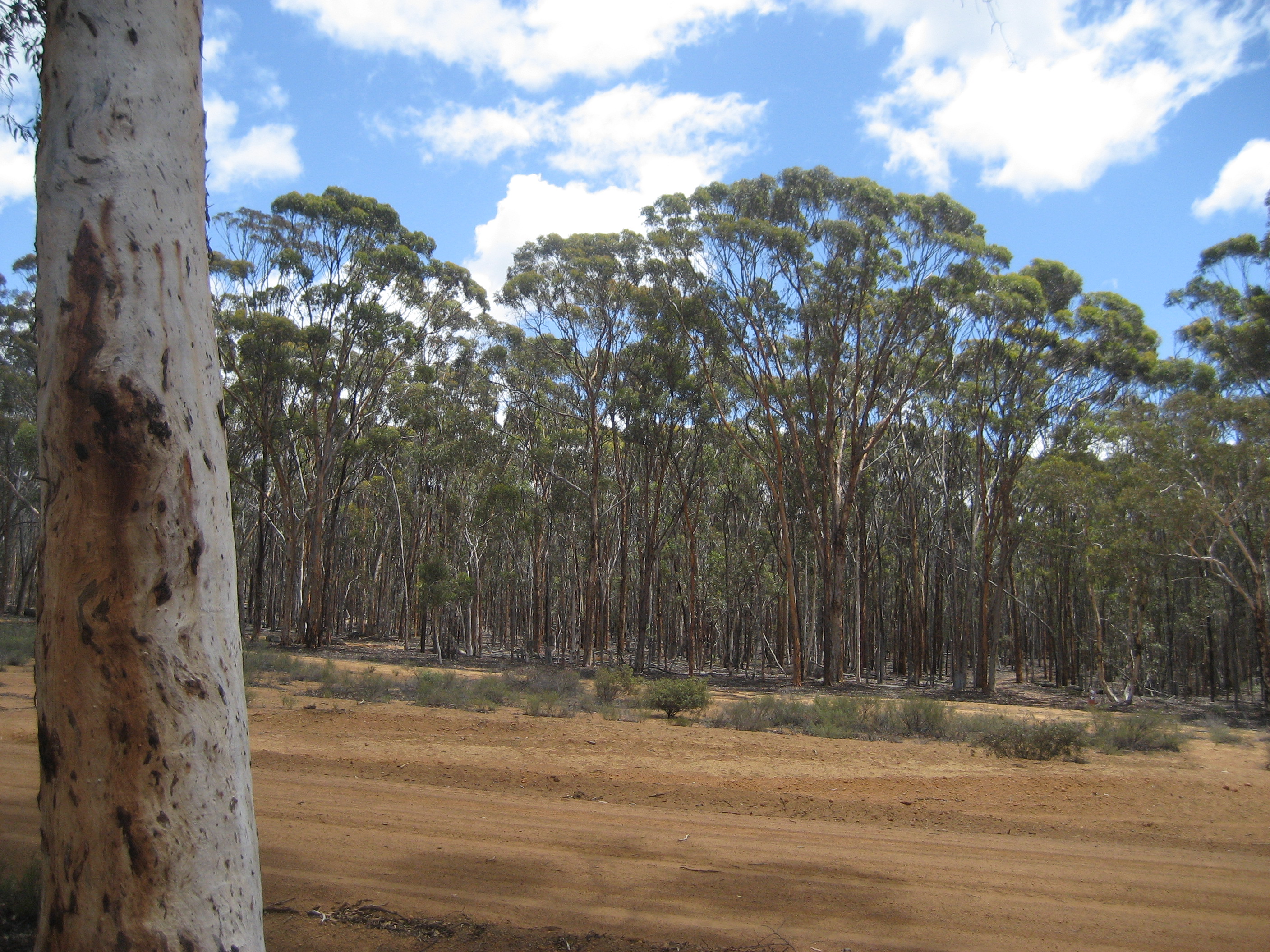
The Woodland lies close to the boundary between the Mallee and Avon Wheatbelt biogeographic regions of the Southwest Botanical Province.[5] It is situated on the western edge of the state's wheatbelt region: the area is a rare remnant of the open eucalypt woodlands which covered much of the wheatbelt prior to land clearing which started from the 1890s. Dryandra's flora is transitional between that of the moister jarrah forest (generally to the south) and the semi-arid wheatbelt (to the east). It is known particularly for its extensive stands of Wandoo (Eucalyptus wandoo), Powderbark Wandoo (E. accedens) and Salmon White Gum (E. lane-poolei), and provides a haven for native flora and fauna while much of the surrounding country is badly affected by salinity. Stands of Jarrah (E. marginata) and Marri (Corymbia calophylla) provide additional top cover, and the understorey contains Rock Sheoak (Allocasuarina huegeliana) and extensive areas of Banksia ser. Dryandra. Until early 2007 this latter shrub was classified as a separate genus Dyrandra after which the Woodland is named. Species include Golden Dryandra (Banksia nobilis) and Prickly Dryandra (B. armata).[3] An arboretum on Tomingley Road holds a range of Australian native plants.
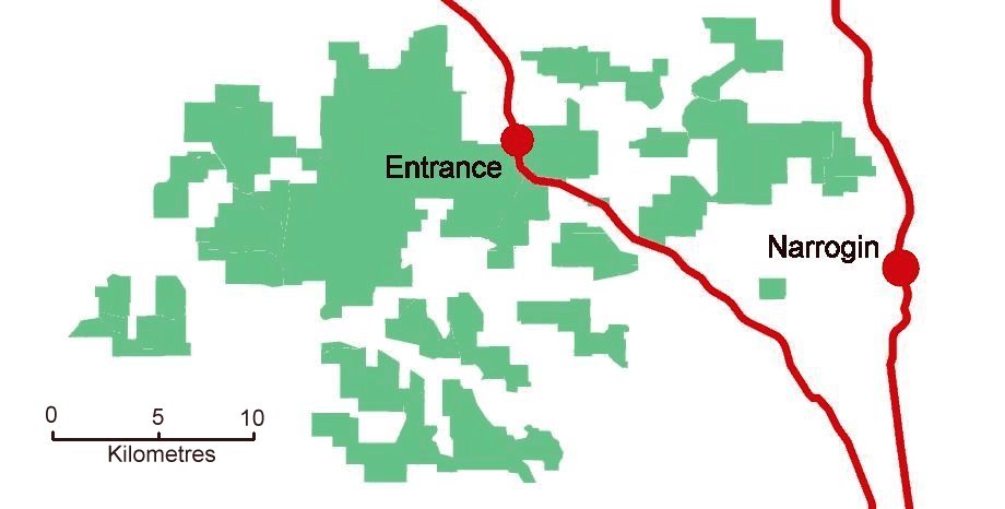
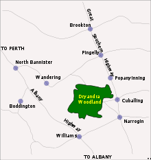 Dryandra Woodland and surrounding townships in the south-west of Western Australia
The 17 lots are surrounded by a largely cleared and agricultural landscape.[1] In some cases, road reserves and other linking corridors of uncleared vegetation remain between the woodland islands. Some neighbouring landowners have revegetated areas of previously cleared private land to form additional corridors between these remnants.[6] For certain animals, movement between blocks is necessary on a daily, seasonal or intermittent basis, to provide access to food, shelter, breeding sites and partners.
Threatened fauna receive extra protection within the 'Barna Mia' animal sanctuary, which is open to visitors by appointment for nocturnal tours on alternate evenings.[7] Native marsupial fauna include the Woylie (Bettongia penicillata), Bilby (Macrotis lagotis), Mala (Lagorchestes hirsutus), Boodie (Bettongia lesueur), and Marl (or Western Barred Bandicoot: Perameles bougainville). The Quenda (or Southern Brown Bandicoot: Isoodon obesulus) is locally extinct but may be reintroduced.[1]
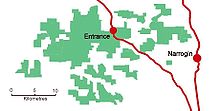 Larger scale map of the Woodlands showing the separation of the lots
The Woodland's position on the transition zone between the wheatbelt and the jarrah forest determines amphibian populations, with several species existing at the eastern or western limits of their range. Herpetofauna includes the Western Marsh Frog (or Golden Flecked Burrowing Frog, Heleioporus barycragus) which is generally restricted to the western Darling Range.[3] There are at least 98 species of bird in the Woodland,[3] including the almost flightless Malleefowl (Leipoa ocellata).
Climatically, Dryandra is described as semi-arid, with a warm, dry, Mediterranean climate. It has seven to eight dry months each year with an annual average rainfall of about 500 millimetres (20 in). Seasonal changes in temperature, rainfall and wind direction are marked and more extreme than coastal areas of the south-west.[8] The wettest months are May through September when about 70% of the annual rainfall occurs. Mean daily maximum temperatures are 30.9 °C (87.6 °F) in January and the mean daily minimum of 5.6 °C (42.1 °F) is in August.[9]
Role in fauna and flora protection
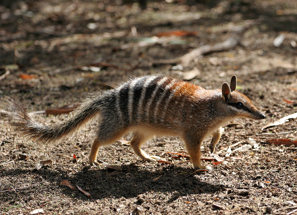
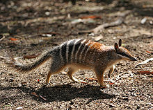 Numbat (Myrmecobius fasciatus)
The following fauna are known to be living in the Woodland and have a conservation status of 'threatened' as recorded in the IUCN Red List:
Common name Scientific name Category Red-tailed Phascogale Phascogale calura Near threatened[10] Short-billed Black-cockatoo
(also known as Carnaby's Black Cockatoo)Calyptorhynchus latirostris Endangered[11] Numbat Myrmecobius fasciatus Vulnerable[12] Chuditch
(also known as Western Quoll)Dasyurus geoffroii Near threatened[13] Malleefowl Leipoa ocellata Vulnerable[14] Major populations of three nationally endangered species exist in the woodlands: the woylie, the red tailed phascogale, and over 50 percent of the total known population of numbat.[3]
Over 800 native flora have been identified within the Dryandra Woodland, including 15 that have been declared priority species under the Department of Environment and Conservation's Declared Rare and Priority Flora List.[15] The conservation codes of P2 thru P4 are for flora that are considered rare but have some populations in areas where they are thought not be under immediate threat; higher numbers denote a lower threat level.
Scientific name Conservation
priority codeGrevillea crowleyae P2 Amanita carneiphylla P2 Andersonia bifida P2 Marianthus dryandra P2 Chamelaucium croxfordiae ms P2 Banksia acanthopoda P2 Persoonia hakeiformis P2 Schoenus aff. clandestinus P2 Triglochin stowardii P3 Acacia deflexa P3 Acacia semitrullata P3 Thysanotus tenuis P3 Banksia cynaroides P4 Gastrolobium tomentosum (Woolly Poison) P4 Mallet
 Mallet plantation
In the early 1900s a significant industry established within the forest and surrounding region harvesting bark from Brown Mallet trees (Eucalyptus astringens),[16][17] a species of eucalypt which grows on and near laterite soils in parts of the southern wheatbelt. Bark sent to Germany for analysis was found to contain more than 40% of high quality, water-soluble tannins suitable for the production of quality leather by the process of tanning.[1]
By the mid 1920s, concerns were being raised about the ability of the area to maintain the supply of naturally grown mallet and by 1929, stands of the naturally grown mallet had almost disappeared. So, between 1925 and 1962 mallet plantations were established under the management of the Forestry Department which, during the Depression, provided employment for sustenance workers who planted some 4,000 hectares (9,900 acres) of mallet, starting near 'Lol Gray' lookout.[18] In 1933, 50 forestry workers were employed in the plantations.[6] Seven steam trains and a sawmill supported the industry within the Woodland. Two dams - 'Lol Gray' and the 'Old Mill Dam' provided good quality water to run the trains, as well as domestic water supplies which were carted by train to nearby towns including Narrogin.[6]
Mallet bark was exported in ground form and was handled by a number of Fremantle exporters, notably Henry Will & Co., Rosenstamms and Joyce Bros.[19] Production after 1959 declined rapidly, coinciding with a world glut, increased royalty and production costs, and increased competition from synthetic tannins. The industry had effectively collapsed by the early 1960s.[1][6]
Replanted forests now extend over approximately 30%, or 8,300 hectares (32 mi²), of Dryandra. Harvesting from plantation areas for timber production continues today under the Department of Environment and Conservation's management plan, which includes a vision for the area over the next 100 years. Conservation studies have shown that the managed harvesting will have no detrimental impact on the fauna habitat.[1]
In 1960, Arthur Hunter, a local farmer, started manufacturing tool handles from naturally fallen and low-grade felled Wandoo and Mallet.[6] This cottage industry has now expanded to produce over 100,000 tool handles each year. As well as tool handles, fencing materials and cutting of firewood for domestic use provide local employment.[1]
Noongar use
Indigenous peoples occupied the southwest of the state for at least the past 40,000 years. In more recent times, thirteen different clans lived in the region. Collectively, the clans were known as Noongars and the people of the Dryandra area were from the Wiilman clan.[18]
The Noongar people have strong cultural links with Dryandra[3] which was known as Wilgadjny.[4] Within the complex, five important archaeological sites have been identified to date, including an ochre pit which was used for body decoration and rock art. One Noongar born in 1910 described the ochre pit as being "a very spirity place" and somewhere to be avoided at night.[4] Other known sites include artefact scatters, stone arrangements and a scarred tree, however the Woodland has not yet been fully surveyed for significant Aboriginal sites.[1]
Following requests from local Indigenous people, the Department of Environment and Conservation is considering the feasibility of permitting some cultural activities including hunting and camping within the Woodland in order to pass on skills to younger members of that community. If permitted, such activities would need to be managed on a sustainable basis to ensure that the conservation goals of the Woodland are not compromised.[1]
Recent history
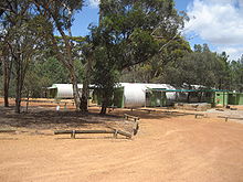 The Currawong Complex adjacent to the Lions village caters for groups of up to 60 visitors
Almost all of the land within the complex today was classified as 'State Forest' in 1903 as an area for the protection of water catchments and growing wandoo and mallet forests.[18]
In 1962, a sub-committee of the Western Australian branch of the Australian Academy of Science made recommendations which were reviewed in 1972 and 1974 by the Environmental Protection Authority of Western Australia. In summary, the recommendations were:
"The Committee emphasises the outstanding value of the Dryandra area as wildlife habitat. This is due largely to the protection and management which the area has hitherto received from the Forests Department. The Committee recommends:- that State forests 51 ('Lol Gray') and 53 ('Montague') remain dedicated to that purpose;
- that no further portions of Dryandra Forest be planted with pines or other exotic species;
- that if any of the mallet plantations are felled they be regenerated to natural bush; and
- that the area be managed by the Forests Department as though it were a fauna and flora reserve and that if at any time the area is relinquished by the Forests Department it be made a Class 'A' reserve for the Conservation of Flora and Fauna, vested in the WA Wildlife Authority."[1]
The recommendations were endorsed by State Cabinet in 1976. Since that time, Dryandra has been managed principally as a nature reserve but also for limited commercial operations related to plantation timber.[1]
In 1995, a management plan was prepared by CALM (now known as the Department of Environment and Conservation) for the Lands and Forest Commission who hold tenure over the State Forests which form the Woodland. The plan recommended (amongst other things) that the entire area be referred to officially as 'Dryandra Woodland' rather than as various State forests in recognition of its structural difference with the taller and denser forests of the Darling Range.[1] Previously, a smaller section had been referred to as 'Dryandra', with other sections known by their various forestry names.
The principal objectives of the plan were:
- to achieve conservation, recreation and timber production goals, and in the next 70 to 100 years for the timber production role to be one of research and development;
- to "maintain and restore the natural environment by promoting the appreciation and study of indigenous flora and fauna, and to preserve any feature of archaeological, historic or scientific interest."[1]
Accommodation and tourism
 The Lions Village accommodation which uses former forestry workers huts
Dryandra Woodland attracts approximately 30,000 visitors per annum, including 5,000 overnight visits at the Dryandra campsite and settlement within the complex.[1] Accommodation is available at the Congelin Camping Ground located near Congelin Dam and at the Lions Dryandra Village which uses restored cottages from the 1920s Forests Department settlement.[20] Adjacent to the cottages is the Currawong Complex which has several Nissen huts acquired from an air force base and now used to accommodate up to 60 people in groups. The Lions Village was established by several Perth based Lions service clubs in 1972 with the intention of providing a holiday camp for disadvantaged children.[21]
Two separate self-drive tours of 20 km (12 mi) and 25 km (16 mi) operate within Dryandra where visitors can follow a marked trail in their own vehicles.[22] On arrival at one of the five or six stop points, an approximate five-minute broadcast through the car's radio (tuned to FM frequency 100 MHz) provides a narrative commentary explaining interesting aspects of the surrounding area. The commentaries are pre-recorded on microchips and broadcast using concealed low power transmitters charged by solar panels. Some of the broadcasts are staged conversations between characters describing day-to-day events in an early forestry worker's life in Dryandra. Others give a more technical explanation of a particular subject applicable to flora or fauna within a short distance of the car.[23] For example, one stop discusses the naturally occurring Poison Pea plant (genus: Gastrolobium spp) in the Woodlands and the extraction and effect of the 1080 poison (sodium fluoroacetate) which occurs in the plant.[24] Native mammalian herbivores have evolved with a high level of genetic tolerance to the toxin which is deadly to introduced species including foxes. Baiting programs including the highly successful Western Shield project use 1080 poison to help control foxes without harming native fauna.[6]
In addition, various 30 minute to five hour bushwalks can be made along signposted trails through the Woodlands, ranging in length from one to 12.5 kilometres.[25]
References
- ^ a b c d e f g h i j k l m n o "Dryandra Woodland Management Plan 1995-2005". Department of Environment and Conservation (DEC). 1995. http://www.naturebase.net/pdf/nature/management/dryandra.pdf. Retrieved 2007-01-07.
- ^ Serventy, Vincent (1970). Dryandra - The Story of an Australian Forest. Sydney: A H & A W Reed. ISBN 0-5890706-6-5.
- ^ a b c d e f "Entry AHD9928". Australian Heritage Database. Department of Sustainability, Environment, Water, Population and Communities. http://www.environment.gov.au/cgi-bin/ahdb/search.pl?mode=place_detail;place_id=9928. Retrieved 2007-01-07.
- ^ a b c "Noongar Land Noogar Spirit (interview with Cliff Humphries)". Western Australian Forest Alliance. http://www.schools.wafa.org.au/nyoongar.htm. Retrieved 2007-01-12.
- ^ Beard, J.S. (1980) A new phytogeographic map of Western Australia. Western Australian Research Notes 3: 37-58.
- ^ a b c d e f Dryandra Woodlands self-drive tour radio broadcast. Department of Environment and Conservation, Date: 10 January 2007
- ^ "Barna Mia". Naturebase, Department of Environment and Conservation. http://www.naturebase.net/content/view/26/1253/. Retrieved 2007-02-21.
- ^ Mc Arthur W.M., Churchward, H.M. and Hick, P.T. (1977) Landforms and soils of the Murray River catchment area of Western Australia. CSIRO Australia Division Land Resource Management Series No 3 pp 1-23.
- ^ "Averages for Narrogin". Bureau of Meteorology. http://www.bom.gov.au/climate/averages/tables/cw_010614.shtml. Retrieved 2007-02-06.
- ^ "Phascogale calura". The IUCN Red List of threatened species. IUCN. 2008. http://www.iucnredlist.org/apps/redlist/details/16888/0. Retrieved 10 January 2010.
- ^ "Calyptorhynchus latirostris". The IUCN Red List of threatened species. IUCN. 2008. http://www.iucnredlist.org/apps/redlist/details/142431/0. Retrieved 10 January 2010.
- ^ "Myrmecobius fasciatus". The IUCN Red List of threatened species. IUCN. 2008. http://www.iucnredlist.org/apps/redlist/details/14222/0. Retrieved 10 January 2010.
- ^ "Dasyurus geoffroii". The IUCN Red List of threatened species. IUCN. 2008. http://www.iucnredlist.org/apps/redlist/details/6294/0. Retrieved 10 January 2010.
- ^ "Leipoa ocellata". The IUCN Red List of threatened species. IUCN. 2008. http://www.iucnredlist.org/apps/redlist/details/141205/0. Retrieved 10 January 2010.
- ^ "Dryandra Woodland Management Plan 1995-2005". DEC. pp. p7, Appendix 1. http://www.naturebase.net/pdf/nature/management/dryandra.pdf. Retrieved 2007-02-02.
- ^ "Brown Mallet". Department of Agriculture and Food. http://www.agric.wa.gov.au/pls/portal30/docs/FOLDER/IKMP/LWE/VEGT/TREES/TAN06.HTM. Retrieved 2007-01-06.
- ^ Wikispecies article on E. astringens
- ^ a b c "Cultural Heritage". Department of Environment and Conservation. http://www.naturebase.net/content/view/374/1254/. Retrieved 2007-01-07.
- ^ Pustkuchen, O.E. (1981). The Way Through - The Story of Narrogin. Perth, Western Australia: Artlook Books Trust. ISBN 0-8644501-0-9.
- ^ "Lions Dryandra Village". dryandravillage.org.au. http://www.dryandravillage.org.au/. Retrieved 2007-01-06.
- ^ Information sign at Dryandra Woodlands Lions Village
- ^ Judith White. "Urban Ecotourism, Case Study 4 – Dryandra Woodland, Western Australia (p47)". Murdoch University. http://tourism.murdoch.edu.au/reports/WhiteCockburnWetlds.pdf. Retrieved 2007-01-12.
- ^ "Sounds of Dryandra Woodland Drive Trail". Naturebase, Department of Environment and Conservation. http://www.naturebase.net/content/view/373/1257/. Retrieved 2007-03-04.
- ^ Gregory T. Chandler, Randall J. Bayer and Michael D. Crisp (2001). "A molecular phylogeny of the endemic Australian genus Gastrolobium ..". American Journal of Botany 88 (9): 1675–1687. doi:10.2307/3558413. JSTOR 3558413. PMID 21669702. http://www.amjbot.org/cgi/content/abstract/88/9/1675. Retrieved 2007-02-15.
- ^ Dryandra Woodland: information and trail guide. Western Australia Department of Environment and Conservation.
Further reading
- Coate, Kevin. 1991. Dryandra State Forest - history and description of the state forest Naturalist News, April 1991, p. 1-2.
External links


Wikimedia Foundation. 2010.