- City of David
-
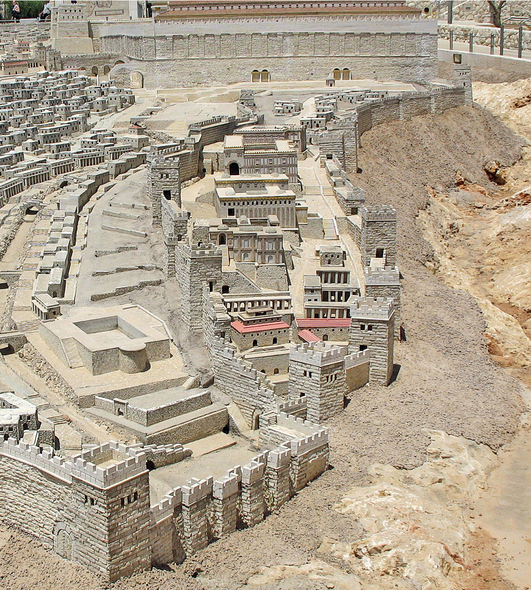
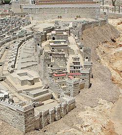 City of David, Holyland Model of Jerusalem
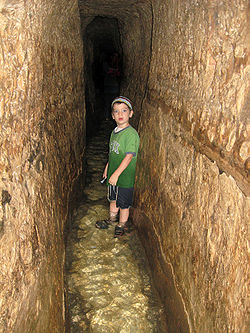 Tourist inside Hezekiah's tunnel 2010
The City of David (Hebrew: עיר דוד, Ir David; Arabic: مدينة داوود) is the oldest settled neighborhood of Jerusalem and a major archaeological site due to recognition as biblical Jerusalem. It is a narrow ridge running south from the Temple Mount. It was a walled city in the Bronze Age and, according to tradition, it is the place where King David built his palace and established his capital. The City of David was naturally defended by the Tyropoeon Valley on its west, the Hinnom valley to the south, and the Kidron Valley on the east; although over time the once-steep valley to the west has been largely filled in.
In the ancient pre-Israelite period, the City of David was separated from the Temple Mount by the Ophel, an uninhabited area which became the seat of government under Israelite rule.[1] During the reign of Hezekiah, the walls of the city were expanded westward, enclosing a previously unwalled suburb in the area now known as the Old City of Jerusalem, west of the Temple Mount.
Today the archaeological dig and visitor center are one of the major tourist destinations in Israel. Although there is currently both Muslim and Jewish housing in the area, archeological digs are ongoing under many of the homes and it is proposed to make the entire ridge into an archaeological park.
Archaeology
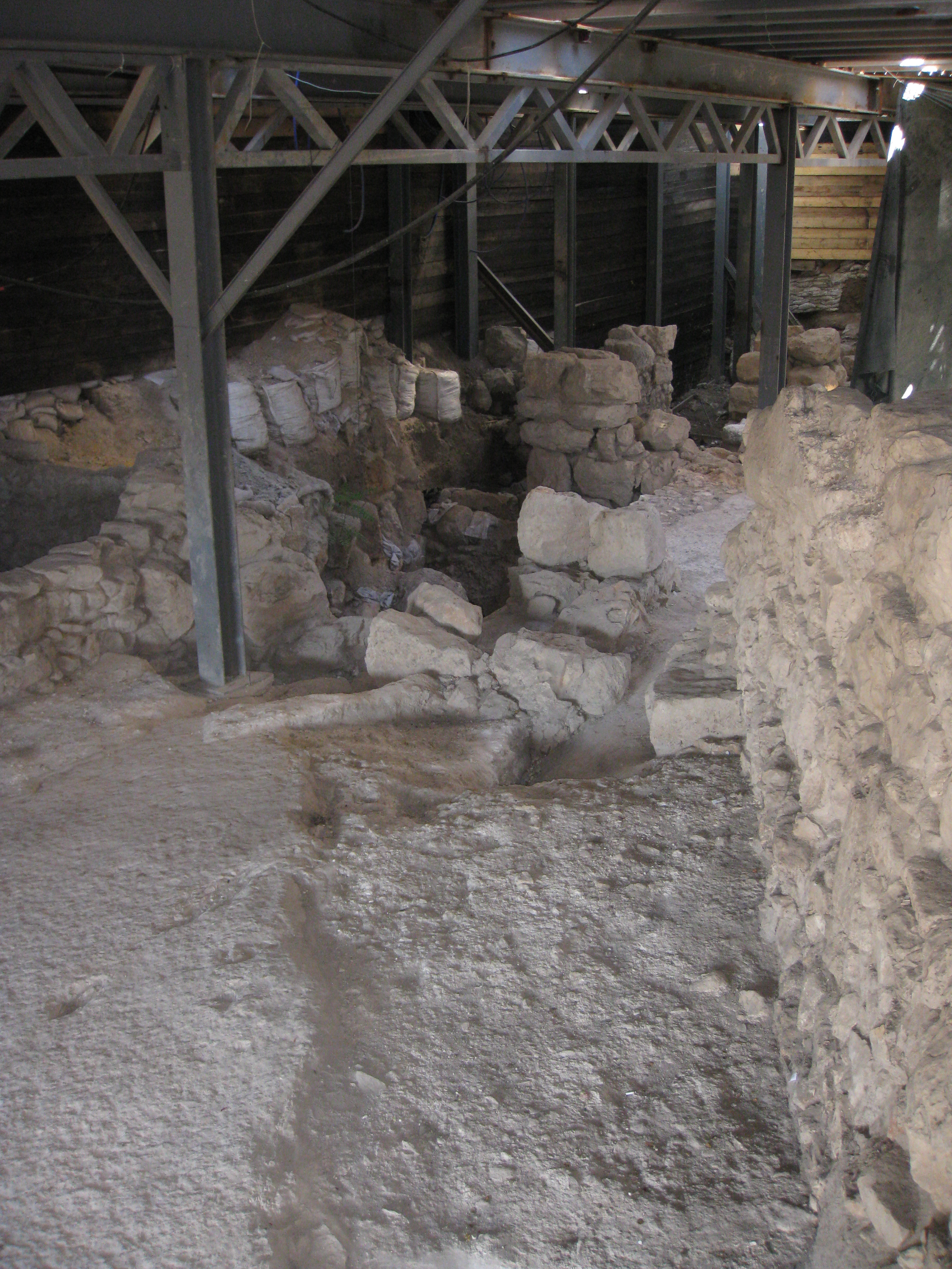
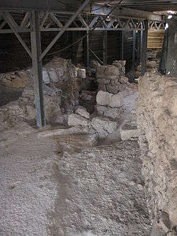 Part of the Large Stone Structure identified by some archaeologists with the remains of King David's Palace.
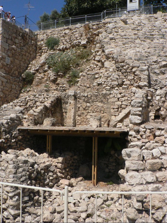
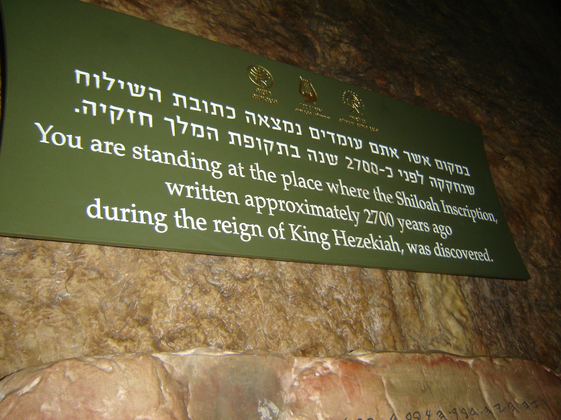
Nahal Kidron, which separated the Ophel from today's Old City, lies hidden beneath the debris of centuries. Archaeological exploration of the area began in the nineteenth century. The area includes several sites of archaeological interest, notably Hezekiah's tunnel (a water supply system, where the Siloam inscription was found), Warren's shaft (an earlier structure, postulated by some to have been a water supply system), and the Pool of Siloam (the presently extant Byzantine-era pool, and the recently discovered Second Temple-period pool). All of these water supply systems drew their water from the Gihon Spring which lies on the Ophel's eastern slope, and is generally considered the reason that the City was built at this location.[1]
The site of the Gihon Spring and Pool of Siloam are incorporated in an archaeological park open to the public. Visitors can wade through Hezekiah's Tunnel, through which the waters of the ancient spring still flow.[2]
The earliest excavations were undertaken by Charles Warren in 1867; there have been numerous excavations since and several digs are currently underway. Complete lists of the Ottoman Era digs [5], British Mandate era digs [6], Jordanian era digs [7] and of the early Israeli era digs [8] are available at the website of the Israel Antiquities Authority.
Chalcolithic (4500–3500 BCE)
Chalcolithic remains include bits of pottery found in clefts in the bedrock by Macalister and Duncan.[3] The expedition also discovered a number of artifices cut into the bedrock. These included places where the rock had been smoothed and others where it had been cut to form flow channels. There were also several groups of small basins, sometimes called cupmarks, cut into the bedrock. These are assumed to have been used for some form of agricultural processing. Macalister and Duncan speculated that they were used in olive oil processing.[3] Edwin C. M. van den Brink, who notes that similar carved basins have been found at Beit Shemesh and near Modi'in-Maccabim-Re'ut speculates that they may have been created by repeated grinding and crushing activity, such as the grinding of grain or the crushing of olives.[4] Eilat Mazar speculates that they were used to collect rainwater.[1]
Early Bronze Age (3500–2350 BCE)
Pieces of pottery.
Middle Bronze Age (2000–1550 BCE)
Middle Bronze Age Jerusalem is mentioned several times in Egyptian texts from the 19th-18th centuries BCE.[5] It is mentioned in this era in the biblical story of Melchizedek.(Genesis 14:18-20) In this period the city is sufficiently large and powerful to construct a "massive" stone wall to defend its water supply, the Gihon Spring, by have been protecting the vulnerable passage from the top of the hill to the spring tower below.[6]
Late Bronze Age (1550–1200 BCE)
Pottery and bronze arrowheads dating form this period have been found.[1]
In 2010, a fragment of a clay tablet dating form the 14th century BCE was uncovered, making it the oldest written document yet uncovered in Jerusalem. It is dated by the writing it bears, in an ancient Akkadian cuneiform script. The text was deciphered by graduate student Takayoshi Oshima working under professor Wayne Horowitz. According to Horowitz, the quality of the writing indicates that this was a royal inscription, apparently a letter from the a king of Jerusalem to the pharaoh in Egypt.[7] Professor Christopher Rollston points out that there is no mention of any personal names or titles and no place names in the document. He notes that the quality of the script is good but that this does not show that it is "international royal correspondence." He also suggests that caution should be taken before positing a definite date as it is not a stratified find, having been discovered after excavation in a 'wet sieving' process.[8]
Iron Age I (1200–980/70 BCE)
 Jebusite city wall.
Jebusite city. A city wall dating to no later than the twelfth century BCE has been uncovered, and neither its existence nor the existence of a fortified city at that date is in dispute. On one side of the controversy are those who maintain the plausibility or validity of the biblical account of a conquest by troops under King David who, as described in the Bible, capture the city not only by breaching the walls,[9] but also by climbing upwards through the ancient water system at the Gihon Spring.[10] The supposition is that the Israelites continued to use the intact Jebusite walls and extended the city northward, under king Solomon, to include the Temple Mount.[11]
Iron Age IIa (1000–900 BCE)
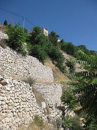
 Stepped Stone Structure (Millo).
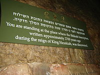 Sign at the center of Hezekiah's Tunnel
The period of the tenth and ninth centuries BCE, corresponding to the biblical Kings David and Solomon, has been the subject of an intense scholarly dispute, as well as of ongoing archaeological investigations.[12]
The 2005 discovery by archaeologist Eilat Mazar of a Large Stone Structure, which she dated to the tenth century BCE, would be evidence of buildings in Jerusalem of a size appropriate to the capital of a centralized kingdom at that time. Others, most notably Israel Finkelstein of Tel Aviv University, argue that the structure could, for the most part, be from the much later Hasmonean period.[13] However, new evidence continues to emerge from the dig. Mazar's date is supported by 10th century imported luxury goods found within the large Stone Structure, including two Phoenician-style ivory inlays once attached to iron objects, comparable objects found in a Phoenician tomb at Achziv suggest that they may have decorated a sword handle.[14] A quantity of luxury round, carinated bowls with red slip and hand burnishing support both the tenth century date and a sophisticated, urban lifestyle.[15] A bone has been radiocarbon dated by Elisabetta Boaretto at the Weizmann Institute, showing a probability date between 1050 and 780 BCE.[15] A large section of a "delicate and elegant" Black-on-red jug, also found in the structure, is of a kind dated to the second half of the tenth century BCE.[16][17]
In 2010 Mazar announced the discovery of what Mazar believed to be a 10th-century BCE city wall. According to Mazar, ""It's the most significant construction we have from First Temple days in Israel," and "It means that at that time, the 10th century, in Jerusalem there was a regime capable of carrying out such construction." The 10th century BCE is the period the Bible describes as the reign of King Solomon. Aren Maeir, an archeology professor at Bar Ilan University, said he has yet to see evidence that the fortifications are as old as Mazar claims. Whilst acknowledging that 10th century BCE remains have been found in Jerusalem he describes proof of strong, centralized kingdom at that time as "tenuous".[18]
Support for Mazar's dating of the wall and the Large Stone Structure to the 10th century comes from the discovery of a major Judean royal fortress at Khirbet Qeiyafa that stood for a mere 20 years sometime in the 11th or 10th century BCE before being destroyed. The site is dated by pottery styles and by two burned olive pits tested for carbon-14 at Oxford University and found to date from between 1050 and 970 BCE, the period most scholars consider to be during the reign of King David.[19] These date shave been challenged with dates for activity at the site suggested as having occurred after 1050 and before 915 BCE. [20] The fortress may be the biblical Sha'arayim.[21]
Necropolis
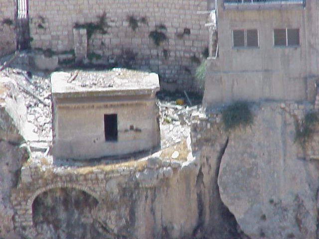
 Remnants of the Tomb of Pharaoh's daughter
The elaborate rock-cut tombs of the Israelite period, dating from the 9th to the 7th centuries BCE are found on the ridge on the far side of the Kidron Valley in and under the Arab village of Silwan.[22] These are large, elaborate tombs of finely-cut stone,such as could only have been built by the highest-ranking members of a wealthy society. According to David Ussishkin, "here ministers, nobles and notables of the kingdom of Judah were buried."[22]
The architecture of the tombs and the manner of burial is different "from anything known from contemporary Palestine. Elements such as entrances located high above the surface, gabled ceilings, straight ceilings with a cornice,13 trough-shaped resting-places with pillows, above-ground tombs, and inscriptions engraved on the facade appear only here."[22] However, the stone benches were carved with headrests in a style borrowed from Egyptian Hathor wig.[23] Ussishkin believes that the architectural similarity to building styles of the Phoenician cities validates the biblical description of Phoenician influence on the Israelite kingdoms, but speculates that some or all of the tombs may have been built by Phoenician aristocrats living in Jerusalem.[22]
Although only three partial inscriptions survive, the paleography makes the dating certain [22] and they suffice for most archaeologists to identify one tomb with the Biblical Shebna, steward and treasurer of King Hezekiah.[24]
Iron Age IIIb (8th century – 586 BCE)
This is the period that corresponds to the biblical Kings Hezekiah through Josiah and the destruction of the Kingdom of Judah by Nebuchadnezzar II.
King Hezekiah secured the city's water supply against siege by digging the Hezekiah Tunnel through bedrock and covering over all signs of the Gihon Spring and the fortifications that had surrounded it in earlier periods. He built the Pool of Siloam as a water reservoir. Hezekiah then surrounded the new reservoir and the city's burgeoning western suburbs with a new city wall.[25][26]
Babylonian and Persian periods (586–322 BCE)
Two bullae in the neo-Babylonian style, one showing a priest standing beside an altar to the gods Marduk and Nabu.[27] A polished, black, stone Scaraboid seal showing a "Babylonian cultic scene" of two bearded men standing on each side of an altar dedicated to the Babylonian moon god Sin. The scaraboid is understood to have been produced in Babylonia, with space left below that altar for a personal name. In that space are Hebrew letters that Peter van der Veen has read as the name Shelomit.[28]
Hasmonean and Herodian periods (167 BCE – 70 CE)
Major archaeological finds include the Pool of Siloam, the Jerusalem pilgrim road, the palace of Queen Helena of Adiabene and the Jerusalem Water Channel. Active Roman-era excavations are also underway at the Givati Parking Lot dig site.[29]
Byzantine and early Islamic Periods (324–1099 AD)
Byzantine era mansion called the House of Eusebius.[30]
Modern period
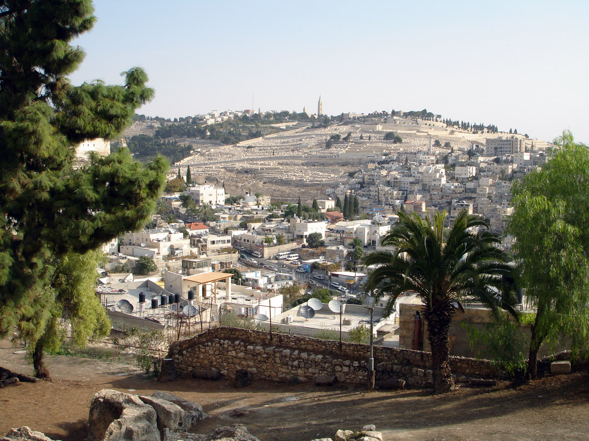
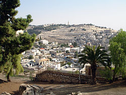 Ir David and the Mount of Olives
Mid-19th century photographs taken by Scotsman James Graham (1853–57) show the ridge of Ir David as being devoid of housing. It is terraced and planted, apparently, with olive trees.[31]
Modern settlement on the ridge began in the City of David in 1873-1874, when the Meyuchas family, a Jewish rabbinical and merchant family that had lived in Jerusalem since their expulsion from Spain, moved a short distance outside the city walls to a house on the ridge.[32] During the latter stages of the Mandate era the nearby Arab village of Silwan expanded up the ridge of the City of David. After the 1948 Arab–Israeli War, the whole area fell on the eastern side of the Green Line under Jordanian control. Arab families continued to live on the ridge of the City of David and to build houses there after 1967. From 1968 to 1977 the Israel Exploration Society started the first excavations at the Ophel, lead by Benjamin Mazar and Eilat Mazar.[33]
The right to control both the archaeological and the residential aspects of the City of David is hotly contested by Israelis and Palestinians.[34] There is a proposal to turn most of the area into an archaeological park,[35] and to restore a part of the Kidron Valley currently occupied by mostly illegally constructed housing owned by Palestinians as a park to be called the Garden of the King.[36]
See also
- Silwan
- First Temple
- Ancient city walls around the City of David
References
- ^ a b c d Mazar, Eilat, Excavations at the Summit of the City of David, Preliminary Report of Seasons 2005-2007, Shoham, Jerusalem and New York, 2009, p. 21.
- ^ Archaeology and the City of David, Rick Sherrod, Good News: A Magazine of Understanding, [1]
- ^ a b Macalister, R.A. and Duncan, J.G., Excavations on the hill of Ophel, Jerusalem, 1923-1925; being the joint expedition of the Palestine Exploration Fund and the 'Daily Telegraph', London, 1926.
- ^ Edwin C. M. van den Brink, "A New Fossil Directer of the Chalcolithic Landscape in the Shephelah and the Samarian and Judaean Hill Countries: Stationary Grinding Facilities in Bedrock", IEJ 58.1 (2008), pp.1-23.
- ^ Mazar, Eilat, Excavations at the Summit of the City of David, Preliminary Report of Seasons 2005-2007, Shoham, Jerusalem and New York, 2009, p. 23.
- ^ 'Massive' ancient wall uncovered in Jerusalem
- ^ [2]"Oldest written document ever found in J'lem," Hartman, July 12, 2010, Jerusalem Post.
- ^ Rollston, Christopher. "Rollston’s Reflections on the Fragmentary Cuneiform Tablet from the Ophel: A Critique of the Proposed Historical Context". http://www.rollstonepigraphy.com/?p=90. Retrieved 15 July 2010.
- ^ I Kings 11:27 and I Chronicles 11:8
- ^ II Samuel 5:8
- ^ I Kings 9:15
- ^ Rachel Ginsberg (2009-06-29). "The world of archeology is rocked by evidence of King David's palace unearthed in Jerusalem". Aish.com. http://www.aish.com/jw/j/48961251.html. Retrieved 2009-06-29.
- ^ Israel Finkelstein, Ze'ev Herzog, Lily Singer-Avitz and David Ussishkin (2007), Has King David's Palace in Jerusalem Been Found?, Tel Aviv: Journal of the Institute of Archaeology of Tel Aviv University, 34(2), 142-164
- ^ Mazar, Eilat, Excavations at the Summit of the City of David, Preliminary Report of Seasons 2005-2007, Shoham, Jerusalem and New York, 2009, pp. 52-3.
- ^ a b Mazar, Eilat, Excavations at the Summit of the City of David, Preliminary Report of Seasons 2005-2007, Shoham, Jerusalem and New York, 2009, p. 52.
- ^ Color photo in Mazar, Eilat, Excavations at the Summit of the City of David, Preliminary Report of Seasons 2005-2007, Shoham, Jerusalem and New York, 2009, p. 53.
- ^ Herzog, H. and Sinver-Avitz, L., Redefining the Center: The Emergence of State in Judah, Tel Aviv, 31/2, 2004, pp. 209-44.
- ^ Jerusalem city wall dates back to King Solomon, Jerusalem Post, Fe. 23, 2010, [3]
- ^ The Journal of Hebrew Scriptures Volume 8, Article 22 ISSN 1203-1542Khirbet Qeiyafa: Sha’arayim by Yosef Garfinkel and Saar Ganor
- ^ Finkelstein, Israel; Eli Piasetzky (June 2010). "Khirbet Qeiyafa: Absolute Chronology". Tel Aviv: Journal of the Institute of Archaeology of Tel Aviv University 37 (1).
- ^ Oldest Hebrew inscription' Discovered in Israelite Fort on Philistine border, Biblical Archaeology Review, March/April 2010, pp. 51-6.
- ^ a b c d e The Necropolis from the Time of the Kingdom of Judah at Silwan, Jerusalem, David Ussishkin, The Biblical Archaeologist, Vol. 33, No. 2 (May, 1970), pp. 33-46,
- ^ Joffe, Alexander, The Rise of Secondary States in the Iron Age Levant, Journal of the Economic and Social History of the Orient, Vol. 45, No. 4, 2002, pp. 425-467.
- ^ "Ancient Jerusalem's Funerary Customs and Tombs: Part Two, L. Y. Rahmani, The Biblical Archaeologist, Vol. 44, No. 4 (Autumn, 1981), pp. 229-235.
- ^ Jerusalem: an archaeological biography, Hershel Shanks,Random House, 1995, p. 80.
- ^ Jewish Quarter Excavations in the Old City of Jerusalem: The finds from areas A, W and X-2 : final report Volume 2 of Jewish Quarter Excavations in the Old City of Jerusalem: Conducted by Nahman Avigad, 1969-1982, Nahman Avigad, Hillel Geva, Israel Exploration Society, 2000.
- ^ Mazar, Eilat, Excavations at the Summit of the City of David, Preliminary Report of Seasons 2005-2007, Shoham, Jerusalem and New York, 2009, pp. 77-8.
- ^ Mazar, Eilat, Excavations at the Summit of the City of David, Preliminary Report of Seasons 2005-2007, Shoham, Jerusalem and New York, 2009, pp. 78-9.
- ^ "2,000 year-old cameo found in Jerusalem," Aug. 30, 2010, Jerusalem Post.
- ^ Macalister, R.A. and Duncan, J.G., Excavations on the hill of Ophel, Jerusalem, 1923-1925 being the joint expedition of the Palestine Exploration Fund and the 'Daily Telegraph', London, 1926.
- ^ Photos available in "Picturing Jerusalem, James Graham and Michael Diness, photographers", ed. Nissan N. Perez, Israel Museum, 2007. p. 31 and others.
- ^ Yemin Moshe: The Story of a Jerusalem Neighborhood, Eliezer David Jaffe, Praeger, 1988, p. 51
- ^ Excavations on the South of the Twemple mount. The Ophel od Biblical Jerusalem, Qedem. Monographs of the Institute of Archaeology, The Hebrew University of Jerusalem , No. 29, 1989 ISSN 0333-5844
- ^ Ahdaf Soueif writes on Ir David's settling of Silwan in the Guardian
- ^ [4]
- ^ id=168833 Gan Hamelech residents wary of Barkat’s redevelopment plan, Abe Selig, Feb. 16, 2010, Jerusalem Post.
External links
- City of David
- From Shiloah to Silwan project
- Shady Dealings in Silwan: An Ir Amim Report
- Did I Find King David's Palace? Biblical Archaeology Review
- The Dig Dividing Jerusalem: Ahdaf Soueif writes on Silwan in the Guardian
Neighborhoods of Jerusalem Old City 
East Jerusalem American Colony • Al Bustan • Al-Issawiya • At-Tur • Bab a-Zahara • Beit Hanina • Jabel Mukaber • Ma'ale ha-Zeitim • Nachalat Shimon • Nof Zion • Ras al-Amud • Sheikh Jarrah • Shimon HaTzadik • Shuafat • Silwan • Sur Baher • Umm Tuba • Wadi al-JozHaredi neighborhoods Batei Munkatch • Batei Ungarin • Beit Yisrael • Ezrat Torah • Geula • Givat Shaul • Har Nof • Kerem Avraham • Kiryat Belz • Kiryat Mattersdorf • Kiryat Sanz • Kiryat Shomrei Emunim • Machanayim • Mea Shearim • Mekor Baruch • Nachalat Ya'akov • Ramat Shlomo • Ramot Polin • Sanhedria • Sanhedria Murhevet • Sha'arei Hesed • Shmuel HaNavi • Tel Arza • Unsdorf • Zikhron MosheCentral Neighborhoods Batei Nissan Bak • Beit David • Beit Ya'akov • Bukharan neighborhood • Even Yisrael • Ezrat Yisrael • Givat Ram • Katamon • Kiryat Shmuel • Kiryat Wolfson • Mahane Israel • Mahane Yehuda • Merhavia • Mishkenot Sha'ananim • Musrara • Nachalat Achim • Nachlaot • Nayot • Neve Sha'anan • Ohel Shlomo • Rehavia • Yemin MosheNorthern Neighborhoods French Hill • Givat HaMivtar • Ma'alot Dafna • Neve Yaakov • Pisgat Ze'ev • Ramat Eshkol • Ramot • Ramot PolinSouthern Neighborhoods Abu Tor • Baka • Beit Safafa • East Talpiot • The German Colony • Gilo • Givat HaMatos • Greek colony • Har Homa • Mekor Chaim • Ramat Rachel • TalpiotWestern Neighborhoods Bayit VeGan • Beit HaKerem • Givat Massuah • Givat Mordechai • Givat Oranim • Har Hotzvim • Ir Ganim • Katamonim • Kiryat HaYovel • Kiryat Menachem • Kiryat Moshe • Malha • Motza • Pat • Ramat Beit HaKerem • Ramat Denya • Ramat Sharett • Romema • Yefeh NofHistoric Neighborhoods See also: Ring NeighborhoodsCoordinates: 31°46′25″N 35°14′08″E / 31.77361°N 35.23556°E
Categories:- Neighbourhoods of Jerusalem
- City of David
- Hebrew Bible mountains
- Archaeological sites in Jerusalem
- Siloam
- David
- Former populated places in Southwest Asia


Wikimedia Foundation. 2010.