- Givat Mordechai
-
Coordinates: 31°45′54″N 35°11′50″E / 31.765°N 35.19722°E
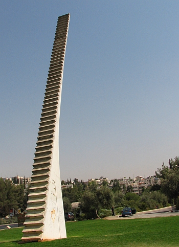
 Jacob's Ladder sculpture, Givat Mordechai, Jerusalem
Givat Mordechai, (Hebrew: גבעת מרדכי, trans: Mordechai's Hill) is a Jewish neighborhood in southwest-central Jerusalem, Israel, midway between the neighborhoods of Nayot and Malcha. The neighborhood was named after an American philanthropist, Maxwell (Mordechai) Abbell of Chicago. [1]
Contents
History
Givat Mordechai was established in 1955 by members of Hapoel Hamizrachi, the forerunner of the National Religious Party, known in Hebrew as Mafdal. Most of the streets are named after leaders of Hapoel Hamizrachi. Shahal Street, for example, is a Hebrew acronym for the religious Zionist leader Rabbi Shmuel Chaim Landau. The population is largely modern Orthodox, with some secular Jews. There are many synagogues and educational institutions in Givat Mordechai. The main campus of the Jerusalem College of Technology is located there, as is the Hebron yeshiva.[2]
Landmarks
The Jerusalem Fire Brigade is headquartered in Givat Mordechai.[3]
Ezra Orion's outdoor sculpture "Stairway" (1979-1980) is located at the entrance to Givat Mordechai in the Elsie Bernadette Garden. It is widely known as "Sulam Yaakov," or "Jacob's Ladder" referencing the story in Book of Genesis (28:11–19).
Givat Mordechai abuts the Pri-Har valley (Gazelle Valley), a large expanse of open fields that is home to a herd of deer and other wildlife. Plans to build residential towers here triggered an outcry from environmentalists and local residents, who managed to block the project. Instead, the area is slated to become a park and a nature reserve.[4]
Notable residents
- Zevulun Orlev, Israeli MK and former minister
- Rabbi Yehuda Amital, head of Yeshivat Har Etzion
References
External links
Neighborhoods of Jerusalem Old City 
East Jerusalem American Colony • Al Bustan • Al-Issawiya • At-Tur • Bab a-Zahara • Beit Hanina • Jabel Mukaber • Ma'ale ha-Zeitim • Nachalat Shimon • Nof Zion • Ras al-Amud • Sheikh Jarrah • Shimon HaTzadik • Shuafat • Silwan • Sur Baher • Umm Tuba • Wadi al-JozHaredi neighborhoods Batei Munkatch • Batei Ungarin • Beit Yisrael • Ezrat Torah • Geula • Givat Shaul • Har Nof • Kerem Avraham • Kiryat Belz • Kiryat Mattersdorf • Kiryat Sanz • Kiryat Shomrei Emunim • Machanayim • Mea Shearim • Mekor Baruch • Nachalat Ya'akov • Ramat Shlomo • Ramot Polin • Sanhedria • Sanhedria Murhevet • Sha'arei Hesed • Shmuel HaNavi • Tel Arza • Unsdorf • Zikhron MosheCentral Neighborhoods Batei Nissan Bak • Beit David • Beit Ya'akov • Bukharan neighborhood • Even Yisrael • Ezrat Yisrael • Givat Ram • Katamon • Kiryat Shmuel • Kiryat Wolfson • Mahane Israel • Mahane Yehuda • Merhavia • Mishkenot Sha'ananim • Musrara • Nachalat Achim • Nachlaot • Nayot • Neve Sha'anan • Ohel Shlomo • Rehavia • Yemin MosheNorthern Neighborhoods French Hill • Givat HaMivtar • Ma'alot Dafna • Neve Yaakov • Pisgat Ze'ev • Ramat Eshkol • Ramot • Ramot PolinSouthern Neighborhoods Abu Tor • Baka • Beit Safafa • East Talpiot • The German Colony • Gilo • Givat HaMatos • Greek colony • Har Homa • Mekor Chaim • Ramat Rachel • TalpiotWestern Neighborhoods Bayit VeGan • Beit HaKerem • Givat Massuah • Givat Mordechai • Givat Oranim • Har Hotzvim • Ir Ganim • Katamonim • Kiryat HaYovel • Kiryat Menachem • Kiryat Moshe • Malha • Motza • Pat • Ramat Beit HaKerem • Ramat Denya • Ramat Sharett • Romema • Yefeh NofHistoric Neighborhoods See also: Ring NeighborhoodsCategories:- Neighbourhoods of Jerusalem
- Orthodox Jewish communities in Jerusalem
- Israel geography stubs

Wikimedia Foundation. 2010.