- Creigiau & St. Fagans
-
Coordinates: 51°30′50″N 3°16′48″W / 51.514°N 3.280°W
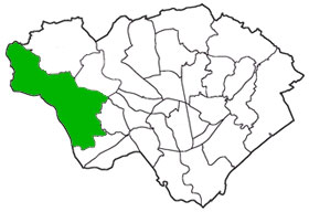
 Creigiau & St. Fagans electoral ward in Cardiff
Creigiau & St. Fagans is an electoral ward of Cardiff, Wales.
The ward covers the village of St. Fagans and a part of the village of Pentyrch and the surrounding rural areas.
The ward falls within the parliamentary constituency of Cardiff West. It is bounded by Rhondda Cynon Taff to the northwest; Pentyrch and Radyr & Morganstown to the northeast; Llandaff and Fairwater to the east; Ely to the southeast; and the Vale of Glamorgan to the southwest
City of Cardiff About Cardiff Architecture · City centre (Arcades) · Culture and recreation · Economy and industry · History (Timeline) · Leisure Centres · Libraries · Media · People · Places · Politics · Sport · Tall Buildings · Transport (Bus · Rail · Cycle · Water · Air)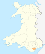
Cardiff templates North Birchgrove · Cathays · Cyncoed · Gabalfa · Heath · Lisvane · Llandaff · Llandaff North · Llanishen · Rhiwbina · Roath · Thornhill · Tongwynlais · WhitchurchWest Caerau · Canton · Creigiau · Culverhouse Cross · Danescourt · Ely · Fairwater · Pentyrch · Pontcanna · Radyr and Morganstown · St FagansSouth East Principal areas of Wales Communities of Cardiff Adamsdown · Butetown · Caerau · Canton · Cardiff Bay · Cathays · Creigiau · Culverhouse Cross · Cyncoed · Danescourt · Ely · Fairwater · Gabalfa · Grangetown · Heath · Lisvane · Llandaff · Llandaff North · Llanishen · Llanrumney · Morganstown · Pentwyn · Pentyrch · Penylan · Plasnewydd · Pontcanna · Pontprennau · Radyr · Rhiwbina · Riverside · Roath · Rumney · Splott · St Fagans · St Mellons & Old St Mellons · Thornhill · Tongwynlais · Trowbridge · Whitchurch
Politics and Government in Cardiff Local Government Local Government
Electoral wardsAdamsdown • Butetown • Caerau • Canton • Cathays • Creigiau & St. Fagans • Cyncoed • Ely • Fairwater • Gabalfa •
Grangetown • Heath • Llanishen • Lisvane • Llandaff • Llandaff North • Llanrumney • Pentwyn • Pentyrch • Penylan • Plasnewydd • Pontprennau & Old St. Mellons • Radyr & Morganstown • Rhiwbina • Riverside • Rumney • Splott • Trowbridge • Whitchurch & TongwynlaisNational Assembly for Wales
Constituencies and AMsCardiff Central (Jenny Rathbone • Lab) • Cardiff North (Julie Morgan • Lab) • Cardiff West (Mark Drakeford • Lab) • Cardiff South and Penarth (Vaughan Gething • Lab)Devolved Administration in Wales
Institutions and VenuesHouse of Commons
Constituencies and MPsEuropean Parliament
Constituencies and MEPsWales (Jillian Evans • Plaid) • (Kay Swinburne • Con) • (John Bufton • UKIP) • (Derek Vaughan • Lab)Headquarters Categories:- Politics of Cardiff
- Cardiff electoral wards
- Glamorgan geography stubs

Wikimedia Foundation. 2010.