- Ha Ling Peak
-
Ha Ling Peak 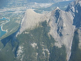
Ha Ling Peak (leftmost), Miner's Col (middle), a section of Mount Lawrence Grassi (rightmost), and the town of Canmore viewed from the south. (Sept. 2006)Elevation 2,407 m (7,897 ft) [1] Prominence 31 m (102 ft) [2] Location Alberta, Canada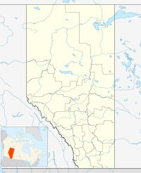
 Ha Ling Peak
Range Canadian Rockies Coordinates 51°03′47.9″N 115°24′06.1″W / 51.063306°N 115.401694°WCoordinates: 51°03′47.9″N 115°24′06.1″W / 51.063306°N 115.401694°W[2] Topo map NTS 82O/03 Climbing Easiest route easy scramble Ha Ling Peak is a peak at the northwestern end of Mount Lawrence Grassi — a mountain located immediately south of the town of Canmore just east of the Spray Lakes road in Alberta's Canadian Rockies. It was previously named Chinaman's Peak but the name was changed to be less offensive.[3]
Contents
Origin of the name
The name of the mountain has been subject to much controversy. Originally, the mountain was referred to locally as The Beehive. In 1896 Ha Ling, a Chinese cook for the Canadian Pacific Railway (some say the Okaloosa Hotel in Canmore) was bet 50 dollars that he could not climb the peak and plant a flag on the summit in less than 10 hours. According to the Medicine Hat News of October 24, 1896, he started the ascent at 7:00 am the previous Saturday morning and was back in time for lunch. As nobody believed his story, he led a party of doubters to the summit where he planted a much larger flag beside the original, this one visible to the naked eye from Canmore. The townsfolk referred to the mountain as Chinaman's Peak in his honour.[4]
The name Chinaman's Peak did not become official until 1980.[3] Later, in 1997 it was renamed Ha Ling Peak as the term Chinaman was viewed as derogatory.
Climbing
There is a hiking route up the south side.[1] On the north side there are several technical climbing routes up the face and a difficult scrambling route up Canmore Couloir, located between Mount Lawrence Grassi and Miner's Col.[5]
References
- ^ a b "Ha Ling Peak". PeakFinder.com. http://peakfinder.com/peakfinder.asp?PeakName=Ha+Ling+Peak. Retrieved 2009-01-02.
- ^ a b "Ha Ling Peak". Bivouac.com. http://www.bivouac.com/MtnPg.asp?MtnId=1555. Retrieved 2009-01-02.
- ^ a b "Peak of Controversy". Alberta Online Encyclopedia. Alberta Heritage. http://www.abheritage.ca/albertans/articles/peaks_2.html. Retrieved 2009-01-02.
- ^ "Ha Ling Peak". Trails.com. http://www.trails.com/tcatalog_trail.asp?trailid=XRM007-062. Retrieved 2009-01-02.
- ^ "Some Ha-Ling climbing routes". rockclimbing.com. http://www.rockclimbing.com/routes/North_America/Canada/Alberta/Canmore/Ha_Ling_Peak/Ha_Ling_Peak/. Retrieved 2009-01-02.
External links
- Scramble description from www.scrambling.ca
- Ha-Ling description from www.peakware.com
- Ha Ling Peak Hiking Trail from hikealberta.com
Categories:


Wikimedia Foundation. 2010.