- Continental Ranges
-
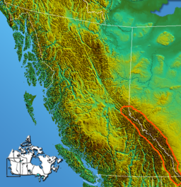
Continental Ranges Range Country Canada Regions British Columbia, Alberta Part of Canadian Rockies Area 65,091 km2 (25,132 sq mi) The Continental Ranges is a name for a major grouping of mountain ranges in the Rocky Mountains located in eastern British Columbia and western Alberta. It is a physiographic designation for use by geologists and is not used by the general public; it is not recognized in Alberta, and does not appear on topographic maps,[1] although the names of its subranges (the Kootenay, Park or Main Ranges, and Front Ranges) are in common use. It is the largest and best-known of the three main such subdivisions of the Canadian Rockies, the others being the Hart Ranges and the Muskwa Ranges.[2]
Sub-ranges
There are three main subdivisions of the Continental Ranges: the Front Ranges, the Park Ranges, and the Kootenay Ranges. Each of those three subdivisions is further divided into individual ranges as follows:
- Front Ranges
- Bare Range
- Bighorn Range
- Bosche Range
- De Smet Range
- Elk Range
- Fairholme Range
- First Range
- Fisher Range
- Goat Range
- Greenhills Range
- High Rock Range
- Highwood Range
- Jacques Range
- Kananaskis Range
- Lizard Range
- Maligne Range
- Miette Range
- Murchison Group
- Nikanassin Range
- Opal Range
- Palliser Range
- Queen Elizabeth Ranges
- Ram Range
- Sawback Range
- Slate Range
- Taylor Range
- Vermilion Range
- Victoria Cross Ranges
- Whitegoat Peaks
- Wisukitsak Range
- Park Ranges, also known as the Main Ranges.
- Blackwater Range
- Blue Range
- Bow Range
- Chaba Icefield
- Clemenceau-Chaba
- Columbia Icefield
- Drummond Group
- Freshfields
- Harrison Group
- Hooker Icefield
- Kitchen Range
- Le Grand Brazeau
- McKale-Chalco Divide
- Mitchell Range
- Morkill Ranges
- Ottertail Range
- Rainbow Range
- Royal Group
- Selwyn Range
- Spray Mountains
- Sundance Range
- The Ramparts
- Trident Range
- Van Horne Range
- Vermilion Range
- Wapta Icefield
- Waputik Icefield
- Waputik Mountains
- Winston Churchill Range
- Kootenay Ranges
- Beaverfoot Range
- Brisco Range
- Hughes Range
- Stanford Range
- Van Nostrand Range
References
- ^ "Continental Ranges". BC Geographical Names. http://apps.gov.bc.ca/pub/bcgnws/names/50603.html.
- ^ Landforms of British Columbia, S Holland, Govt of BC Bulletin No. 58, 1976
 Canadian Rockies
Ranges - Ball
- Bare
- Beaverfoot
- Blue
- Bow
- Crowsnest
- Elk
- Fairholme
- Flathead
- High Rock
- Kananaskis
- Livingstone
- Lizard
- Maligne
- Massive
- Misty
- Morrissey
- Palliser
- President
- Queen Elizabeth
- Rainbow
- Ram
- Sawback
- Sentinel
- Sir Winston Churchill
- Slate
- South Jasper
- Sundance
- Terminal
- Tower of London
- Vermilion
- Victoria Cross
- Waputik
- Continental Ranges
- Hart Ranges
- Muskwa Ranges
Mountains Passes Glaciers Parks and protected areas World Heritage Sites- Canadian Rocky Mountain Parks World Heritage Site
- Waterton-Glacier International Peace Park
National- Parks: Banff
- Jasper
- Kootenay
- Yoho
- Waterton Lakes
- Historic Sites: Jasper House
- Jasper Park Information Centre
- Yellowhead Pass
- Athabasca Pass
- Howse Pass
- Kootenae House
- Kicking Horse Pass
- Skoki Ski Lodge
- Twin Falls Tea House
- Abbot Pass Refuge Cabin
- Cave and Basin
- Banff Park Museum
- Sulphur Mountain Cosmic Ray Station
- First Oil Well in Western Canada
Provincial (AB)- Parks: Bow Valley
- Bragg Creek
- Elbow-Sheep
- Ghost River
- Kananaskis
- Peter Lougheed
- Sheep River
- Siffleur
- Spray Valley
- White Goat
- Willmore
- Historic Sites: Frank Slide
Provincial (BC)Ski resorts - Castle Mountain
- Fernie
- Fortress Mountain
- Lake Louise
- Little Mac
- Marmot Basin
- Mount Norquay
- Nakiska
- Powder King
- Sunshine Village
Communities See also: Geography of Canada portal Coordinates: 52°00′00″N 117°30′00″W / 52°N 117.5°W

This article about a specific Canadian geological feature is a stub. You can help Wikipedia by expanding it. - Front Ranges

