- Abbot Pass hut
Geobox| alpine hut
name = Abbot Pass hut
native_name =
other_name =
category =
image_caption =
official_name =
etymology_type = Named for
etymology =Philip Stanley Abbot
nickname =
symbol =
country = CAN
state_type = Province
state = AB
state1 = BC
region =Banff National Park
region1 =Yoho National Park
district =
municipality =
location =Abbot Pass
elevation = 2926
prominence =
lat_d = 51 | lat_m = 21 | lat_s = 54 | lat_NS = N
long_d = 116 | long_m = 17 | long_s = 12 | long_EW = W
coordinates_no_title = 1
length = | length_orientation =
width = | width_orientation =
height =
depth =
volume =
area =
author_type = Built by
author =Canadian Pacific Railway
style = Stone Cabin
material = Stone
established_type = Built in
established = 1922
date =
government_type = Governed by
government =Parks Canada
owner_type = Operated by
owner = Alpine Club of Canada
public = Reservations required
visitation = | visitation_date =
access = ViaLake O'Hara
whs_name =
whs_year =
whs_number =
whs_region =
whs_criteria =
iucn_category =
free_type = Capacity | free = 24
free1_type = Heating | free1 = Woodstove (helicopter ed in)
free2_type = Lighting & Cooking | free2 =Propane (helicopter ed in)
free3_type = Sleeping | free3 = Dormitory style
free4_type = Drinking water | free4 =Snowmelt (boil or filter)
free5_type = Human waste | free5 =Outhouse (helicopter ed out)
free6_type = GPS coordinates | free6 = NAD83 11U 549660 5690657
free7_type = Map reference | free7 = 82N/8 (Lake Louise)
free8_type =Grid reference | free8 = 495903
map_caption =
map_background =
map_locator =
map_locator_x =
map_locator_y =
website = http://www.alpineclubofcanada.ca/facility/abbot.html
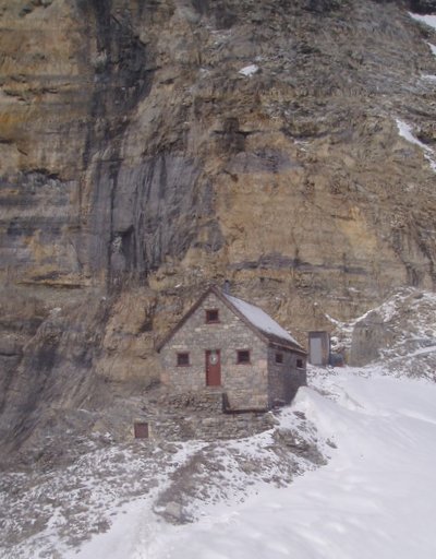
footnotes =The Abbot Pass hut is an alpine hut located at an altitude of 2925 metres (9,598 feet) in the middle ofAbbot Pass in theCanadian Rockies , nestled between Mount Victoria andMount Lefroy . The hut is directly on thecontinental divide on the boundary betweenBanff National Park inAlberta andYoho National Park inBritish Columbia . It is the second highest permanently habitable structure in Canada after theNeil Colgan hut . The hut is maintained by theAlpine Club of Canada . [cite book
last = Haberl
first = Keith
title = Alpine Huts: A guide to the facilities of the Alpine Club of Canada
publisher = Alpine Club of Canada
date = 1997
pages = pp. 61-68
isbn = 0-920330-32-0]History
The pass and the hut are named after
Philip Stanley Abbot , who became the first mountaineering fatality in North Americacite book
last = Scott
first = Jim
title = Backcountry Huts & Lodges of the Rockies & Columbias
pages = pp. 76-77
publisher = Johnson Gorman Publishers
year = 2001
isbn = 0-921835-58-2 ] after he fell in an attempt to make the first ascent of Mount Lefroy in 1896. The hut was originally built in 1922 by Swiss guides working for theCanadian Pacific Railway to shelter clients attempting to climb Victoria and Lefroy. Much of the construction material was carried from Lake Louise on horseback across the Victoria Glacier and winched or carried on guides' backs up the pass on a route known as "The Deathtrap" because of its exposure to avalanches and crevasses. [cite web
first = Dave
last = Birrel
title = Abbot Pass
work = PeakFinder
publisher = Rocky Mountain Books
date = 2007
url = http://www.rmbooks.com/peakfinder/passes.asp?passname=Abbot+Pass
accessdate = 2007-12-22]The CPR operated the hut for 40 years, and in the 1960s turned the operation over to
Parks Canada , which renovated it with the help of volunteers. In 1985 Parks Canada turned the hut over to theAlpine Club of Canada , which has renovated it several times since. The Abbot Pass hut was designated a National Historic Site in 1997. [cite web
last = Parks Canada
title = Abbot Pass Refuge Cabin National Historic Site of Canada
work = National Historic Sites
publisher = Government of Canada
date = 2007
url = http://www.pc.gc.ca/pn-np/bc/yoho/natcul/natcul11_e.asp
accessdate = 2007-12-22]Access
Abbot Pass (and the hut) may be approached from either the
Lake O'Hara area on theBritish Columbia side (hiking pastLake Oesa , or the more technically demanding route from Lake Louise on theAlberta side. The hut is rarely used in winter due to avalanche hazard.From Lake O'Hara
The approach via
Lake O'Hara is by far the most popular route into the hut. It is safer and less technical than going in via "the Deathtrap" or the "Fuhrmann Ledges". It involves about 900 metres (3,000 feet) of elevation gain and 3 to 5+ hours from Lake O'Hara to the hut depending on conditions and the strength of the party. People should not automatically assume they can always get to the hut, since some groups have been caught out overnight on the trail or stranded at the hut in bad weather conditions.The first hurdle on this approach is getting on the bus to Lake O'Hara. The bus is operated by
Parks Canada and is used to control the number of people going to Lake O'Hara. Reservations are difficult to obtain; however an automatic reservation on the bus can be obtained by booking a reservation at the Abbot Pass hut with theAlpine Club of Canada . Persons doing so should carry proof of their reservation because they will not be able to get on the bus without it. The alternative is to walk 10 km up the access road carrying all their equipment.From Lake O'Hara, people going to the hut can follow the signed
hiking trails toLake Oesa to a sign marking the end of the Parks Canada trail, at which point it becomes largelyscrambling . A trail has been built to the hut by the Alpine Club, but parts of it are sometimes erased by rockslides, so route finding skills are helpful. It is steep and covered withscree . Ahelmet is a good safety precaution in case ofrockfall , and anice axe in case of ice or snow on the trail. Oneavalanche fatality has occurred on the route, so it should not be undertaken when avalanches are possible. [ cite book
last = Patton
first = Brian
coauthors = Robinson, Bart
title = Canadian Rockies Trail Guide, Eighth Edition
publisher = Summerthought Publishing
date = 2007
pages = pp. 274-275
isbn = 0-9782375-0-1]From Lake Louise
The route from
Lake Louise involves significant objective hazards. A broad path leads from theChateau Lake Louise along the lake shore past the teahouse and on to thePlain of Six Glaciers . It then continues on into the deep gorge betweenMount Victoria andMount Lefroy - known as The Deathtrap. Persons going through this should move rapidly in case ofserac fall oravalanche s from the glaciers above. It involves crossing a number ofcrevasse s in the glacier and may be impassible due to wall-to-wallbergschrund at the upper end. This is not an attractive route and should only be attempted by strong alpinists when there is deep snow cover on the glacier.cite book
last = Scott
first = Jim
title = Backcountry Huts & Lodges of the Rockies & Columbias
pages = pp. 76-77
publisher = Johnson Gorman Publishers
year = 2001
isbn = 0-921835-58-2 ]Activities
The hut is often used as a base for alpine climbing on Mount Victoria and
Mount Lefroy (both over 3400 metres / 11,000 feet), and as a destination in itself for ambitious hikers. One of the reasons for the popularity of the hut is that climbers can bag both Victoria and Lefroy in a weekend.The normal route up Mount Lefroy (3423 m / 11,230 ft) is via the west face, going straight up the slopes from the hut toward the summit. There are routes up three separate gullies from the hut. The choice of the best one depends on snow conditions. [cite book
last = Dougherty
first = Sean
title = Selected Alpine Climbs in the Canadian Rockies
publisher = Rocky Mountain Books
date = 1991
pages = pp. 92-94
isbn = 0-921102-14-3]The most popular route up Mount Victoria (3464 m / 11,365 ft) is from the hut via the southeast ridge to the south summit. Another popular route is a traverse of Mount Victoria, which can be done in either direction, either to or from the hut. [cite book
last = Dougherty
first = Sean
title = Selected Alpine Climbs in the Canadian Rockies
publisher = Rocky Mountain Books
date = 1991
pages = pp. 95-100
isbn = 0-921102-14-3]In a rarely-observed feat of ursine mountaineering, a
grizzly bear was once seen doing the traverse of Mount Victoria via Abbot Pass.Fact|date=December 2007 They are only occasional visitors to the hut, however.Facilities
The hut sleeps 24 on its upper floor, and has both a wood stove for heating and drying, and a propane system for cooking and lighting. The kitchen is stocked with standard cooking utensils. Wood and propane are flown in annually by helicopter, by the Alpine Club of Canada. There is an outhouse a short distance from the hut. Since human waste must be flown out by helicopter at great cost, visitors should avoid dumping garbage in the toilet.
Nearby
* Mount Victoria
*Mount Lefroy
* Lake Louise
*Lake O'Hara
*Elizabeth Parker hut Maps
* cite map
publisher = Chrismar Mapping Services
title = Lake O'Hara
scale = 1:20,000
series = The Adventure Map
year =
edition =
section =
url = http://www.chrismar.com/P03AMap.htm
isbn = 0-929140-39-7
accessdate = This map shows trails and area highlights in detail
* cite map
publisher = Gem Trek Publishing
title = Lake O'Hara
scale = 1:20,000
series = Guides for Hiking and Recreation in the Canadian Rockies
year =
edition =
section =
url = http://www.gemtrek.com/lakeohara.html
isbn = 1-895526-38-7
accessdate = This map shows trails and area highlights in detail
* cite map
publisher = Gem Trek Publishing
title = Lake Louise and Yoho
scale = 1:50,000
series = Guides for Hiking and Recreation in the Canadian Rockies
year =
edition =
section =
url = http://www.gemtrek.com/lakelouise.html
isbn = 1-895526-64-7
accessdate =
* cite map
publisher = Canadian Government
title = 82N/8 (Lake Louise)
scale = 1:50,000
series =National Topographic System (NTS)
edition =
section =
url = http://maps.nrcan.gc.ca/index_e.php
accessdate =References
Further reading
* cite book
last = Beers
first = Don
title = The Wonder of Yoho
publisher = Rocky Mountain Books
date = 2003
url = http://www.rmbooks.com/books/beewon.htm
isbn = 0-921102-29-1
* cite book
last = Copeland
first = Kathy
coauthors = Copeland, Craig
title = Don't Waste Your Time in the Canadian Rockies: The Opinionated Hiking Guide
publisher = Hikingcamping.com
date = 2004
url = http://hikingcamping.com/time_canadian_rockies.php
isbn = 0-9689419-7-4
* cite book
last = Corbett
first = Don
title = The 11,000ers of the Canadian Rockies
publisher = Rocky Mountain Books
date = 2004
url = http://www.rmbooks.com/books/cor11000.htm
isbn = 1-894765-43-5External links
* [http://www.alpineclubofcanada.ca/facility/abbot.html Abbot Pass hut] at the [http://www.alpineclubofcanada.ca/ Alpine Club of Canada]
* [http://bivouac.com/GtxPg.asp?GtxId=230 Abbot Pass hut at bivouac.com]
* [http://www.weather.ec.gc.ca/ Weather forecasts from Environment Canada]
* [http://www.avalanche.ca/ Public avalanche bulletins from the Canadian Avalanche Centre]
* [http://www.pc.gc.ca/pn-np/bc/yoho/index_e.asp Yoho National Park] at [http://www.pc.gc.ca/index_e.asp Parks Canada]
* [http://earth.google.com/ Google Earth] Find the Abbot Pass hut at 51°21′54″ N, 116°17′12″ W
Wikimedia Foundation. 2010.