- Mount Sarbach
-
Mount Sarbach 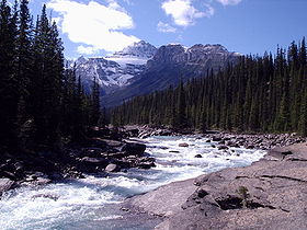
Mount Sarbach seen from Mistaya CanyonElevation 3,155 m (10,351 ft) [1] Prominence 412 m (1,352 ft) [1] Location Location Alberta, Canada Range Canadian Rockies Coordinates 51°52′35″N 116°46′0″W / 51.87639°N 116.766667°WCoordinates: 51°52′35″N 116°46′0″W / 51.87639°N 116.766667°W Climbing First ascent 1897 by J. Norman Collie and G.P. Baker Mount Sarbach is a mountain located in Banff National Park between Mistaya River and Howse River and is visible from the Icefields Parkway. The mountain is named after Peter Sarbach, a mountain guide from Switzerland, who guided the first ascend by J. Norman Collie and G.P. Baker in 1897.
References
- ^ a b "Mount Sarbach". Bivouac.com. http://www.bivouac.com/MtnPg.asp?MtnId=1707. Retrieved 2009-01-02.
External links
Categories:- Mountains of Alberta
- Alberta geography stubs

Wikimedia Foundation. 2010.