Mistaya Canyon

Mistaya Canyon
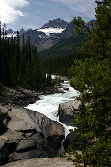
A picture of Mistaya Canyon with a peak in the background.

Mistaya Canyon is a canyon in the western part of the Alberta province of Canada. It is formed by the Mistaya River. Tourists who are visiting Banff National Park often visit it because of its distinctive curvy canyon walls and because it is easy to access, being just off the Icefields Parkway. The 0.5 km trail to the canyon is located at a large parking area on the west side of the Parkway, part way up the long hill south of the North Saskatchewan River. There are actually two such parking areas on the hill; the Mistaya one is clearly marked by signs on the highway and at the beginning of the trail. The trail is an easy walk in summer but too steep for wheelchairs. The canyon is deep and there are no railings. The trail is icy in early spring.

Hikers will find that the Howse Pass Trail continues past the canyon. Coordinates: 51°57′01″N 116°43′00″W / 51.95028°N 116.7166667°W / 51.95028; -116.7166667 (Mistaya Canyon)


Wikimedia Foundation. 2010.

Игры ⚽ Нужно решить контрольную?

Look at other dictionaries:

  • Mount Sarbach — vom Mistaya Canyon aus gesehen Höhe 3.155  …   Deutsch Wikipedia

  • Banff National Park — Infobox protected area | name = Banff National Park iucn category = II caption = Location of Banff National Park in Canada locator x = 52 locator y = 168 location = Alberta, Canada nearest city = Calgary, Alberta lat degrees = 51 lat minutes = 10 …   Wikipedia

  • Банф (национальный парк) — У этого термина существуют и другие значения, см. Банф (значения). Национальный парк Банф …   Википедия

  • Peyto Lake — Infobox lake lake name = Peyto Lake image lake = Peyto Lake Banff NP Canada.jpg caption lake = Peyto Lake seen from Bow Summit image bathymetry = caption bathymetry = location = Banff National Park, Alberta, Canada coords =… …   Wikipedia

  • Mount Sarbach — seen from Mistaya Canyon Elevation 3,155 m (10,351 ft)  …   Wikipedia

  • Banff National Park — Banff Nationalpark Ältester Nationalpark in Kanada, Mount Chephren und Waterfowl Lake (vom Icefield Parkway aus) …   Deutsch Wikipedia

  • Valley of the Ten Peaks — Banff Nationalpark Ältester Nationalpark in Kanada, Mount Chephren und Waterfowl Lake (vom Icefield Parkway aus) …   Deutsch Wikipedia

  • Banff-Nationalpark — Ältester Nationalpark in Kanada, Mount Chephren und Waterfowl Lake (vom Icefield Parkway aus) …   Deutsch Wikipedia

  • Autoroute 93 — Promenade des Glaciers Promenade des Glaciers Autres noms Autoroute 93 Longueur …   Wikipédia en Français

  • Icefields Parkway — Promenade des Glaciers Promenade des Glaciers Autres noms Autoroute 93 Longueur …   Wikipédia en Français

Share the article and excerpts

Direct link
Do a right-click on the link above
and select “Copy Link”