- Columbia Icefield
-
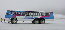
Athabasca Glacier snow coach

 Athabasca Glacier snow coach
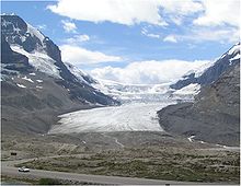
The Columbia Icefield is an icefield located in the Canadian Rockies, astride the Continental Divide of North America. The icefield lies partly in the northwestern tip of Banff National Park and the southern end of Jasper National Park. It is about 325 km² in area, 100 to 365 metres (328 to 1,197 ft) in depth and receives up to seven metres (275 in) of snowfall per year. The icefield feeds eight major glaciers, including:
- Athabasca Glacier
- Castleguard Glacier
- Columbia Glacier
- Dome Glacier
- Stutfield Glacier
- Saskatchewan Glacier
Some of the highest mountains in the Canada Rockies are located around the edges:
- Mount Andromeda (3,450 m)
- Mount Athabasca (3,491 m)
- Mount Bryce (3,507 m)
- Castleguard Mountain (3,090 m)
- Mount Columbia (3,747 m)
- Mount King Edward (3,490 m)
- Mount Kitchener (3,505 m)
- North Twin Peak (3,684 m)
- South Twin Peak (3,566 m)
- Snow Dome (3,456 m)
- Stutfield Peak (3,450 m)
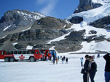
Parts of the Icefield are visible from the Icefields Parkway. The Athabasca Glacier has receded significantly since its greatest modern-era extent in 1844. During the summer months visitors to the area can travel onto the glacier in the comfort of large "snowcoaches". The Columbia Icefield is also a major destination for ski mountaineering in the winter months.
The icefield was first reported in 1898 by J. Norman Collie and Hermann Woolley after they had completed the first ascent of Mount Athabasca.
The Athabasca River and the North Saskatchewan River originate in the Columbia Icefield, as do tributary headwaters of the Columbia River.[1] As the icefield is atop a triple Continental Divide these waters flow ultimately north to the Arctic Ocean, east to Hudson Bay (and thence to the North Atlantic Ocean), and south and west to the Pacific Ocean. Hudson Bay, in some watershed divisions, is considered to be in the Arctic watershed, in which case this would arguably not be a triple continental divide point.
See also
References
- ^ Drainage Basins, from The Atlas of Canada.
External links
- Columbia Icefield - Brewster Snocoach Tours and sightseeing trips in the Canadian Rockies
- The Icefields Parkway
- Columbia Icefield on Bivouac
- The Columbia Icefield and the Athabasca Glacier
Coordinates: 52°09′26″N 117°18′50″W / 52.15722°N 117.31389°W
Categories:- Canadian Rockies
- Glaciers of Alberta
- Glaciers of British Columbia
- Geology of the Rocky Mountains
- Visitor attractions in Alberta
- Visitor attractions in British Columbia
- Great Divide of North America
- Ice fields
Wikimedia Foundation. 2010.


