- Mica Dam
-
Mica Dam 
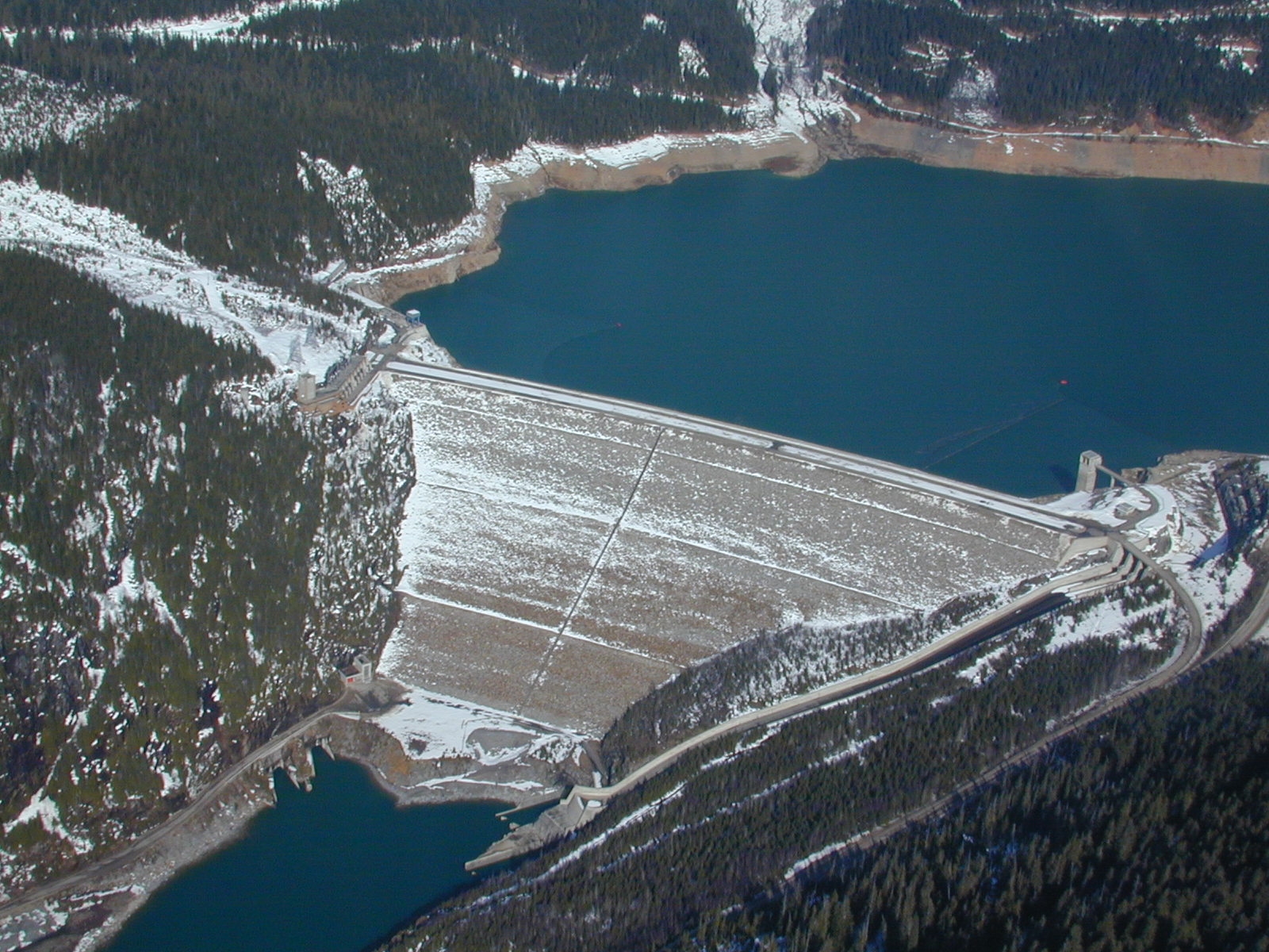
Aerial view of the Mica DamLocation Mica Creek, British Columbia, Canada Coordinates 52°04′40″N 118°33′59″W / 52.07778°N 118.56639°WCoordinates: 52°04′40″N 118°33′59″W / 52.07778°N 118.56639°W Opening date 29 March 1973 Owner(s) BC Hydro Dam and spillways Height 240 m (787 ft) Impounds Columbia River Reservoir Creates Kinbasket Lake Capacity 15 km3 (12,000,000 acre·ft) Surface area 430 km2 (170 sq mi) Power station Type No Turbines 4 Installed capacity 1,740 MW The Mica Dam is a hydroelectric dam spanning the Columbia River 135 kilometres north of Revelstoke, British Columbia, Canada. Completed in 1973 under the terms of the 1964 Columbia River Treaty, the Mica powerhouse has a generating capacity of 1,740 MW. The dam is operated by BC Hydro. The Mica Dam, named after the nearby settlement (now drowned under the lake) of Mica Creek and its associated stream in turn named because of the abundance of mica minerals in the area, is one of the largest earthfill dams in the world. The reservoir for the dam is Kinbasket Lake, which was created when the dam was built. Water below the dam flows south directly into Revelstoke Lake, the reservoir for the Revelstoke Dam. The dam's underground powerhouse was the second largest in the world at the time of its construction, and was the first installation of sulphur hexafluoride (SF6) insulated switchgear in North America. It is also the dam farthest up the Columbia River.[1]
Contents
History
Mica Dam was operational on March 29, 1973.[2] The dam was built to a height of 244 metres (801 ft) above bedrock, near the first location of the village Mica Creek. At the time, the dam was one of three storage dams built by the provincial power company BC Hydro, within the description of the Columbia River Treaty. The dam operated with a 427-square-kilometre (165 sq mi) reservoir containing 15 cubic kilometres (12,000,000 acre·ft) of live storage in McNaughton Lake.
The underground powerhouse, begun in 1973 was built to be 54 metres (177 ft) high, 24 metres (79 ft) wide and 237 metres (778 ft) long. In 1976, the first two electrical generators were commissioned and in 1977 two more were completed bringing the total capacity of the powerhouse to 1740 MW. Another two generators are scheduled to be added and operational in 2014 and in 2015, for a total generating capacity of 2,805 MW.[3]
The Mica powerhouse delivers its power to Nicola Substation via a 500-kilovolt, 570-kilometre (350 mi) transmission line. A second power transmission line for hydroelectric power was built to the Meridian Substation near Port Moody, British Columbia, Canada. In 1980 McNaughton Lake was renamed to Kinbasket Lake. A number of small communities were inundated by the creation of Kinbasket Lake, and comprised a region known as the Big Bend Country, a subregion of the Columbia Country. Among these towns were Mica, Big Bend, and Downie.
Mica Dam was built to provide 7,000,000 acre·ft (8.6 km3) of water storage as outlined in the Columbia River Treaty, plus another 5,000,000 acre·ft (6.2 km3), referred to as "non-Treaty storage". Since 1977 BC Hydro and the Bonneville Power Administration (BPA) have made a series of long and short term agreements for using non-Treaty storage. Negotiations for a new long-term agreement began in 2011. If implemented, it would manage non-Treaty storage until 2024.[4]
See also
- Revelstoke Dam
- Keenleyside Dam
- Hydroelectric dams on the Columbia River
References
- ^ "Columbia River Basin Clickable Map". United States Army Corps of Engineers. http://www.nwd-wc.usace.army.mil/report/colmap.htm. Retrieved 27 May 2011.
- ^ page 3, Kelowna Capital News, December 29, 1976, "New Generators, Boost in Mica power scheduled in 1977"
- ^ BC Hydro News, July 28, 2010 "One of world's largest earthfall dams to add 1,000 MW by 2015"
- ^ "BPA and BC Hydro seek new long-term water storage agreement". Bonneville Power Administration. http://www.bpa.gov/corporate/BPANews/ArticleTemplate.cfm?ArticleId=article-20110524-01. Retrieved 27 May 2011.
External links
Hydroelectric dams on the Columbia River Bonneville · The Dalles · John Day · McNary · Priest Rapids · Wanapum · Rock Island · Rocky Reach · Wells · Chief Joseph · Grand Coulee · Keenleyside · Revelstoke · Mica
Categories:- Dams on the Columbia River
- Dams in British Columbia
- Hydroelectric power stations in British Columbia
- Columbia Country
Wikimedia Foundation. 2010.