Wanapum Dam

Wanapum Dam

Infobox_Dam
dam_name=Wanapum Dam
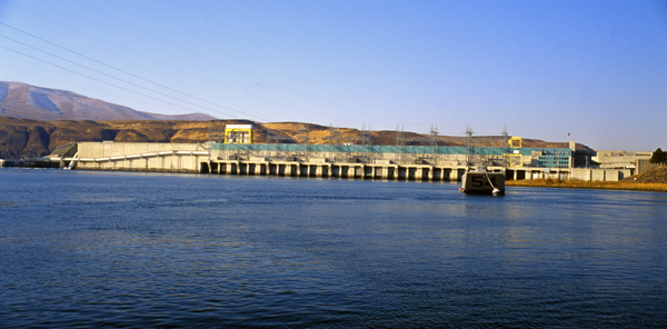


caption=
official_name= Wanapum Dam
crosses= Columbia River
reservoir= Lake Wanapum
locale=
maint=
length=
height=
width=
began= 1959
open= 1963
closed=
cost= $195,000,000
reservoir_capacity=
reservoir_catchment=
reservoir_surface=
bridge_carries=
bridge_width=
bridge_clearance=
bridge_traffic=
bridge_toll=
bridge_id=
map_cue=
map_


map_text=
map_width=200px
coordinates=
lat=
long=
extra=

Wanapum Dam is a hydroelectric project located on the Columbia River downstream from Vantage, Washington where Interstate 90 crosses the Columbia in Grant County, Washington. It is owned by the Grant County Public Utility District. Its reservoir is named Lake Wanapum.

The dam, and its lake, are named after the Wanapum Indians.

The dam has a rated capacity of 1,038,000 kilowatts [ [http://www.gcpud.org/aboutus/wanapumdam.htm| Grant County Public Utility District Website] ]

History

The Wanapum dam was originally licensed in 1955 for a period of 50 years. Construction was initiated in 1959 with initial beneficial operation in 1963. The initial license expired in 2005, after which the Grant County PUD operated the dam on yearly license extensions while negotiations for license extension proceeded. The Federal Energy Regulatory Commission approved a license extension of 44 years for both the Wanapum dam and the downstream Priest Rapids dam on April 17, 2008. The license extension was conditioned upon programs to:
* modernize the power generation capability of the dam,
* monitor water quality,
* improve wildlife habitat,
* protect nearly 700 Wanapum Tribe archaeological sites in the vicinity, and
* enhance recreation with new campsites, picnic areas and trails. [Article titled 'License OK'd for Columbia Dams'; Tri-City Herald published by McClatchy Company; Kennewick, Wa.; April 20, 2008; page A6 ]

External links

*Geolinks-US-cityscale|46.875213|-119.971004

References

Crossings navbox
structure = Crossings
place = Columbia River
bridge = Wanapum Dam
bridge signs =
upstream = Vantage Bridge
upstream signs =
downstream = Beverly Railroad Bridge
downstream signs =


Wikimedia Foundation. 2010.

Игры ⚽ Нужно сделать НИР?

Look at other dictionaries:

  • Wanapum — The Wanapum tribe of Native Americans formerly lived along the Columbia River from above Priest Rapids down to the mouth of the Snake River in what is now the U.S. state of Washington. About 60 Wanapum still live near the present day site of… …   Wikipedia

  • Priest Rapids Dam — Infobox Dam dam name=Priest Rapids Dam caption=From the west side of the Columbia River official name= crosses= reservoir=Priest Rapids Lake locale= maint= length= height= width= began=July 1956 open=1959 (First Generation) 1961 (Full Completion) …   Wikipedia

  • Bonneville Dam — Das Bonneville Bauwerk mit Staudamm, Wasserkraftwerken, den Schleusen und dem See Lake Bonneville (im Hintergrund) …   Deutsch Wikipedia

  • Grand Coulee Dam — Grand Coulee Talsperre Grand Coulee Staumauer Lage …   Deutsch Wikipedia

  • High Arrow Dam — Arrow Lake Der Arrow Lake ist ein durch den Bau des Hugh Keenleyside Dam entstandener See im Süden von British Columbia, der vom Columbia durchflossen wird. Lage Der 232 km (145 Meilen) lange See reicht vom Hugh Keenleyside Dam etwa 10 km… …   Deutsch Wikipedia

  • Hugh Keenleyside Dam — Arrow Lake Der Arrow Lake ist ein durch den Bau des Hugh Keenleyside Dam entstandener See im Süden von British Columbia, der vom Columbia durchflossen wird. Lage Der 232 km (145 Meilen) lange See reicht vom Hugh Keenleyside Dam etwa 10 km… …   Deutsch Wikipedia

  • Keenleyside Dam — Arrow Lake Der Arrow Lake ist ein durch den Bau des Hugh Keenleyside Dam entstandener See im Süden von British Columbia, der vom Columbia durchflossen wird. Lage Der 232 km (145 Meilen) lange See reicht vom Hugh Keenleyside Dam etwa 10 km… …   Deutsch Wikipedia

  • Ginkgo/Wanapum State Park — Ginkgo Petrified Forest State Park/Wanapum Recreational Area is a convert|7470|acre|km2|0|sing=on state park at Vantage, Washington including 27,000 feet (8200 metres) of freshwater shoreline on the Columbia River. It contains many examples of… …   Wikipedia

  • Lake Wanapum — Infobox lake lake name = Wanapum Lake image lake = caption lake = image bathymetry = caption bathymetry = location = Washington coords = coord|46|55|56|N|119|58|24|W|display=inline,titleGNIS|1509280|Wanapum Lake] type = reservoir inflow =… …   Wikipedia

  • Grand Coulee Dam — This article is about the dam itself. For the song by Woody Guthrie, see Grand Coulee Dam (song). Grand Coulee Dam …   Wikipedia

Share the article and excerpts

Direct link
Do a right-click on the link above
and select “Copy Link”