- Rocky Reach Dam
Infobox_Dam
dam_name=Rocky Reach Dam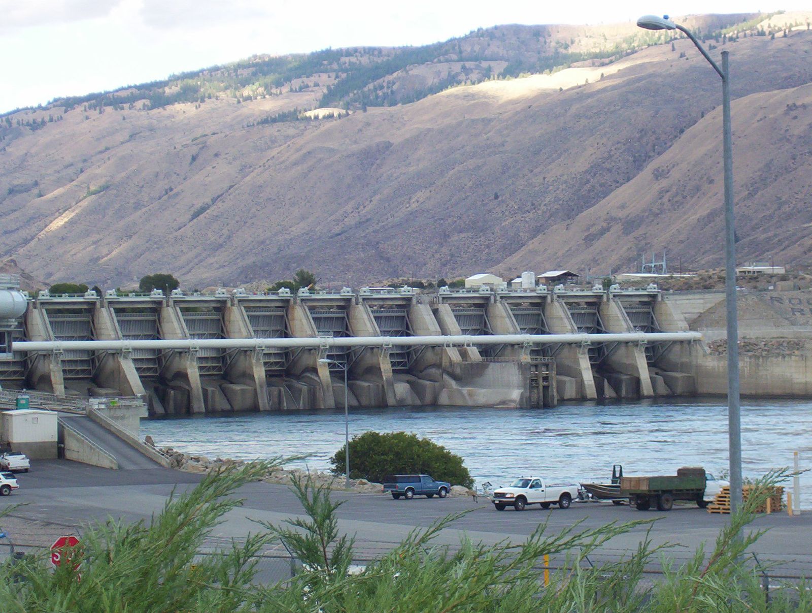
caption=
official_name=
crosses=
reservoir=
locale=
maint=
length=
height=
width=
began=1956 (Phase One)
1969 (Phase Two)
open=
closed=
cost=
reservoir_capacity=
reservoir_catchment=
reservoir_surface=
bridge_carries=
bridge_width=
bridge_clearance=
bridge_traffic=
bridge_toll=
bridge_id=
map_cue=
map_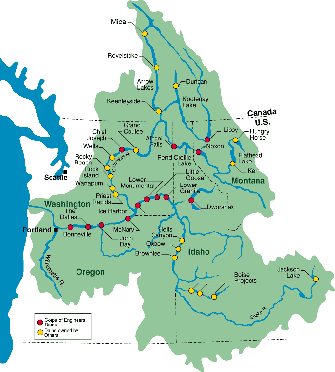
map_text=
map_width=200px
coordinates=
lat=
long=
extra=Rocky Reach Dam is a
hydroelectric dam in theU.S. state ofWashington .Chelan County Public Utility District 's "PAGENAME and Hydro Project" is located in north centralWashington state, USA on theColumbia River , about seven miles (11 km) upstream from the city of Wenatchee. By river, the dam is convert|215|mi|km below the Canadian border, and convert|473|mi|km above the mouth of the Columbia atAstoria, Oregon . The reservoir impounded by the dam isLake Entiat .Hydropower and environmental stewardship
More than 7 million people throughout the Northwest benefit from clean, renewable energy produced at Rocky Reach. The project is also nationally recognized for efforts to protect the environment. [cite web
url= http://www.chelanpud.org/rocky-reach-hydro-project.html
title= Rocky Reach Hydro Project
accessdate= 2008-03-13
publisher= Chelan CountyPublic utility district ] A first-of-its-kind juvenile fish bypass system was completed in 2003 to help young salmon and steelhead on their way to the ocean. [cite web
url=http://www.fluent.com/about/news/newsletters/01v10i2/a14.htm
title= Pumps Assist Migrating Salmon on the Columbia River
work= Fluent NEWS
accessdate= 2007-10-11
date= Winter 2001
publisher= Fluent] A major powerhouse upgrade started in 1995 includes new turbines that are more fish friendly. [ McKee, C, and G. Rossi, "Rocky Reach Kaplan Turbines: Development of Fish-FriendlyRunners," Hydropower into the Next Century, Barcelona, Spain, 1995, as cited in www.tva.gov/environment/pdf/rri_aree.pdf.] Improvements to turbines and generators are also designed to improve efficiency and reliability. [cite web
url= http://www.chelanpud.org/rocky-reach-hydro-project.html
title= Rocky Reach Hydro Project
accessdate= 2007-10-11
publisher= Chelan CountyPublic utility district ]History
The Rocky Reach site has long been recognized for its hydroelectric potential. The
United States Army Corps of Engineers first considered the site in its 1934 "308 Report". In the 1950s, the site became the focus of extensive studies by the PUD. Geological contour maps were studied, construction costs were estimated, and lengthy computations on such things as the forces and stresses a dam would have on the surrounding area were made.The original site selected for the Rocky Reach Project by the U.S. Army Corps of Engineers was about one mile (1.6 km) upriver from where the dam is today. The present site was found to have superior rock for anchoring the dam, and the river channel is narrower at that location.
The Rocky Reach Project was developed over a period of about 15 years. Construction of the dam and original powerhouse with seven generating units began in 1956 for the purpose of power production and flood control. The addition of four more units began in 1969 after ratification of the
Columbia River Treaty between the United States and Canada. The additional units were installed primarily to make use of stored water released from reservoirs in Canada and theLibby Dam reservoir inMontana .The District received a preliminary permit for the Project from the Federal Power Commission (FPC) on
August 10 ,1954 . An application to construct and operate the dam was filed with the same agency onJanuary 13 ,1956 . The Federal Power Commission issued a license to build the Project six months later, onJuly 12 ,1956 . Construction of the dam and original powerhouse began onOctober 2 ,1956 under the supervision of the District's engineering design firm, Stone and Webster Engineering Corporation. The immediate task was the installation of cofferdams to seal off the area designated for the spillway from the river flow during low water.Following spillway construction, the powerhouse was built. A total of 3.3 million cubic yards of dirt and rock were moved during the five-year initial construction. Employment peaked at 2,184 in July 1959. The initial seven generating units were placed in commercial operation on
November 1 ,1961 , six months ahead of schedule. OnSeptember 1 ,1966 , the District filed an application with the Federal Power Commission to amend the Project License to add four generating units. The FPC issued the license amendmentMay 23 ,1968 . The second phase of construction beganApril 22 ,1969 , and was completedDecember 1 ,1971 . The expansion work increased the power plant's generating capability by 60 percent, from 815,000 kilowatts to 1.287 million kilowatts.The Project was financed through the sale of revenue bonds. A revenue bond is a pledge of future revenues generated by the project to repay debt. No tax money was used. The original project, which cost $273.1 million, was financed with a $23.1 million bond issue completed in November 1956 to allow for an early construction start. It was followed by a completion bond issue of $250 million in January 1958.
Included in the Project costs were the relocation of a rail line, highways, land acquisition, relocation of the Town of Entiat, and financing. The subsequent powerhouse expansion and addition of four generating units completed in 1971 were financed by a revenue bond issue of $40 million, sold in July 1968.
Repayment of the revenue bonds is guaranteed through power sales contracts between the Chelan County Public Utility District and the purchasers of Rocky Reach power: PacifiCorp,
Portland General Electric Company,Puget Sound Energy ,Avista Corp., theAluminum Company of America (ALCOA) which has a plant just south of Wenatchee, and the District's electric distribution system. Each of the contracts covers a period extending 50 years after the November 1961 starting date of commercial operation for the initial seven generating units, or until final payment is made on the $273 million in bonds sold for the initial phase of the Project, whichever is longer. The contracts expire in November 2011.The original Project License was issued
July 11 ,1957 by theFederal Power Commission . The license expires in 2006. Prior to that, the District will be required to submit an application for renewal.Gallery
ee also
*
Hydroelectric dams on the Columbia River
*List of reservoirs and dams in the United States References
External links
* [http://rockyreachdam.com Rocky Reach Dam Website]
Wikimedia Foundation. 2010.