- Vaalserberg
-
Vaalserberg 
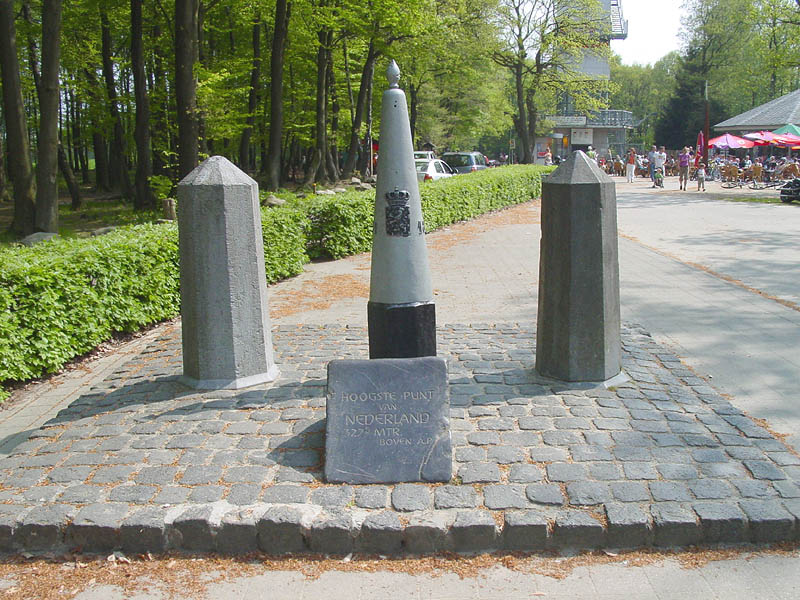
The highest point in the European part of the NetherlandsElevation 322.7 m (1,059 ft) Translation Mount Vaals (English) Location Limburg,
 Vaalserberg
 Netherlands
Coordinates 50°45′17″N 6°01′15″E / 50.75472°N 6.02083°ECoordinates: 50°45′17″N 6°01′15″E / 50.75472°N 6.02083°E The Vaalserberg ("Mount Vaals") is a hill 322.7 metres (1,059 ft) in height and the highest point in the European part of the Netherlands. The Vaalserberg is located in the province of Limburg, at the south-easternmost edge of the country in the municipality of Vaals, near the eponymous town, some three kilometres west of Aachen.
Before 10 October 2010, the Vaalserberg was the highest point in the Netherlands, until upon the dissolution of the Netherlands Antilles when Mount Scenery on Saba (the highest point in the Kingdom of the Netherlands) became part of the Netherlands.
 Drielandenpunt
Contents
Three-Country Point
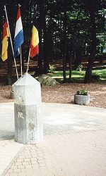
The Vaalserberg is also the location of the tripoint between Germany, Belgium and the Netherlands and its summit is therefore referred to as Drielandenpunt ("Three-Country Point") in Dutch, or Dreiländereck ("Three-Country Corner") in German, or Trois Frontières ("Three Borders") in French.
Between 1830 and 1919, the summet briefly was a quadripoint, bordering also Neutral Moresnet.
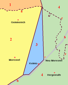 Legend:(3) Neutral Moresnet
The current Belgian-German-border is not the same as the former eastern border of Moresnet with Prussia; it lies a little more to the east. Therefore, 5 different borders came together in this point, however never more than 4 at the same time - except possibly for the period 1917-1920, where the border situation was not clear and not undisputed.
This border intersection has made the Vaalserberg a well-known tourist attraction in the Netherlands with a tower on the Belgian side (Dutch: Boudewijntoren; French: Tour Baudouin) offering a grand panorama of the surrounding landscape. This tidy and urbanised development stands in marked contrast to the rough cinder parking area that makes up the Belgium sector and the wooded nature reserve on the German side.
Four-borders road
The road leading up to this point on the Dutch side is called the "Viergrenzenweg" ("four-borders road"), probably because of the former neutral Moresnet, while the roads in Belgium "Route des Trois Bornes" and Germany "Dreiländerweg" only refer to three.[1]
Road Cycling
The Vaalserberg is often used in the Amstel Gold Race and is climbed halfway through the race. The climb is named in the roadbook of the Gold Race as 'Drielandenpunt' and is follwed by the Gemmenich climb.
See also
- List of mountains and hills in North Rhine-Westphalia
References
Categories:- Mountains and hills of Belgium
- Mountains and hills of the Netherlands
- Mountains and hills of North Rhine-Westphalia
- Belgium–Netherlands border crossings
- Germany–Netherlands border crossings
- Belgium–Germany border crossings
- Border tripoints


Wikimedia Foundation. 2010.