- Quadripoint
In
geography , a quadripoint is a point on the Earth that touches four distinct regions. Such points are often called "four corners ", from the corners of the four regions meeting there. [One could argue that, if one region lies on one side of astraight line border, and the other three are on the opposite side of this line, there are only three "corners" plus a straight line. However in geometry the straight line in this context would be considered to form astraight angle measuring 180°.]International quadripoints
At present there are no generally recognized quadripoints involving four different countries, although a claim is often made that one exists at coord|17|47|32|S|25|15|52|E between
Namibia ,Zambia ,Zimbabwe andBotswana at thethalweg confluence of the Zambezi River with theChobe River nearKazungula . The various boundary definitions involved are subject to differing and disputed interpretations; only one combination of interpretations and river conditions might have produced a quadripoint, but that combination never obtains in reality. [cite book| title = African Boundaries: A Legal and Diplomatic Encyclopaedia | first = Ian | last = Brownlie | coauthors = Ian R. Burns | pages = 1098-1108 | chapter = Botswana-Zambia (Quadripoint issue) | publisher = C. Hurst & Co. | location =London | year = 1979 | id = ISBN 0-903983-87-7; summarized at [http://home.worldonline.dk/jesniel/border/african_tripoints.htm#bwnazm African tripoints: Botswana-Namibia-Zambia] by Michael Donner / Jesper Nielsen.] [cite book| title = International Law and the Protection of Namibia's Territorial Integrity | first = S. | last = Akweenda | pages = 201-3 | chapter = VI: Quadripoint Theory | publisher = Martinus Nijhoff | location =Netherlands | date = 1997-04-23 | id = ISBN 90-411-0412-7]Close calls
If the Kazungula case above is not accepted as a quadripoint, it is the place where tricountry points are closest together, as the distance between the tripoints is believed by the most careful authorities to be on the order of 100 meters.
Where two tripoints occur very close to each other, they can look like a quadripoint on a map of insufficient resolution. For example, the
Kazakhstan /Russia /People's Republic of China tripoint at coord|49|5|59|N|87|18|45|E is only 39 km fromTavan Bogd Uul , a Russia/Mongolia /People's Republic of China tripoint. It may look like a quadripoint on some maps, but at more detailed resolution, it is clear that Kazakhstan and Mongolia never touch. [coord|49.04|N|87.4|E|]An even closer example of this is between the tripoints of
Armenia /Turkey /Nakhichevan ,Azerbaijan andIran /Turkey /Nakhichevan ,Azerbaijan , which are about 9 km from each other at coord|39|41|0|N|44|48|30|E.Although four countries border
Lake Chad , there is no quadripoint ofChad ,Niger ,Nigeria , andCameroon within the lake. The two tripoints are about 86 km apart.Similarly, the
Gulf of Aqaba in theRed Sea borders four countries, but does not contain a quadripoint ofJordan ,Saudi Arabia ,Egypt , andIsrael .Some political maps of the South Pacific enclose many island nations within straight lines drawn along parallels of latitude or meridians of longitude, often with a maritime quadripoint indicated for
Solomon Islands ,Tuvalu ,Kiribati , andNauru . [One such map is at |accessdate=2006-12-10]Previously existing would-be four-country points
Between 1830 and 1920 there was a quadripoint at the convergence of
Belgium ,Prussia /Germany , theNetherlands , andMoresnet . coord|50.75|N|6.02|E| [http://commons.wikimedia.org/wiki/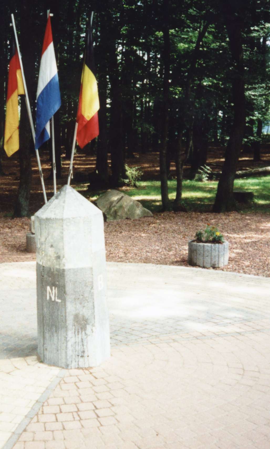
] [http://nl.wikipedia.org/wiki/Afbeelding:Vierlandenpunt.jpg] This point has often been called a quadricountry point, though Moresnet was never truly a country but rather only a neutral territory or condominium of the Netherlands and Prussia (originally), and of Belgium and Germany (ultimately).From 1922 to 1991 there was a de facto quadripoint coord|29.1|N|46.55|E| between
Iraq ,Kuwait ,Kingdom of Nejd /Saudi Arabia and theSaudi-Iraqi neutral zone , although precise boundaries were never specified by the three sovereign states.Fewer than four countries
There are quadripoints where four border lines touch each other at one point, but involving fewer than four countries. This occurs with a practical exclave which touches the main territory (or another exclave) at a single point. The Belgian enclaves H1 and H2 in
Baarle-Hertog touch each other at one such point, while the Netherlands also crosses it. [See The Baarle Enclaves website, including [http://www.grenspalen.nl/archief/baarle-nassau-in-english.html : overview with photograph of the H1-H2 quadripoint] and [http://www.grenspalen.nl/archief/baarle-map%20met%20enclave-aanduidingen-center.jpgMap including H1 and H2 enclaves] ]Similarly, the
Austria n town ofJungholz lies totally within Germany except that it borders Austria at one single point.Cooch Behar in India is linked withBangladesh by at least one such point (and very possibly a second).econdary quadripoints
A secondary quadripoint (or "quadrisecondary point") is the meeting of four political subdivisions (for example, provinces, states, or cantons). The four subdivisions may all belong to one country, or they may involve two or three different countries.
By analogy, one could speak of tertiary quadripoints ("quadritertiary points") where, for example, four different counties meet at one point, and quaternary quadripoints ("quadriquaternary points") where four municipalities meet, etc. However, these lesser categories would not have been considered as interesting as primary or "world class" quadripoints, if indeed any such quadricountry points had ever actually existed. For example, many of the counties of Nebraska or the towns of Maine are demarcated as squares in a grid.
Trinational
At coord|54.36435|N|22.79228|E|, there is a trinational secondary quadripoint: to the northwest is
Russia (specifically the Russian exclaveKaliningrad Oblast ); to the northeastLithuania ; and to the southwest and southeast two Voivodships (provinces) ofPoland :Warmian-Masurian Voivodship andPodlaskie Voivodeship . [http://maps.msn.se/map.aspx?C=54.36435,22.79228&L=EUR&S=800,740&A=49] The quadripoint exists thanks to the way the border between Poland and Russian SFSR was defined in 1945 by thePotsdam Agreement .At or around coord|19|N|52|E|, there appears to be another trinational secondary quadripoint: to the north is Saudi Arabia, to the southeast is
Oman , and to the southwest twoGovernorates of Yemen :Hadhramaut Governorate to the westsouthwest andAl Mahrah Governorate to the southsouthwest.Binational
The three German states
Bavaria ,Saxony , andThuringia (the two tripoints are about 20 km apart), do not form a quadripoint with theCzech Republic ; nevertheless it is frequently commented on.A similar seeming quadripoint exists near Biaufond at coord|47.1655|N|6.86|E| between the Swiss cantons of Jura, Neuchâtel, and Berne on the one hand, and the French département
Doubs on the other hand. In this case, the two tripoints are separated by only about 250 m/830 ft.On the border of Sweden and Norway, at coord|65.11888|N|14.32592|E|, there appears to be a binational secondary quadripoint where two
Counties of Norway ,Nord-Trøndelag andNordland , meet twoCounties of Sweden ,Västerbotten County andJämtland County .cite web | url=http://groups.yahoo.com/group/BoundaryPoint/message/19589?l=1 | accessdate=2006-06-20 | work=BoundaryPoint (Yahoo! Groups) | title=an apparent nose2janontvb binational quadripoint | author=Kallos, Aletheia | date=2006-06-08 |] [http://maps.msn.se/map.aspx?C=65.11888,14.32592&L=EUR&S=800,740&A=49]Another binational secondary quadripoint appears to exist on the border of Argentina and Uruguay where the Argentinian provinces of Corrientes and Entre Rios also very probably meet the Uruguayan departments of Artigas and Salto.
National
The Argentine provinces of La Pampa, Río Negro, Mendoza and Neuquén form a quadripoint at coord|37|34|00|S|68|14|00|W|region:AR_scale:2000000, though Rio Negro has disputed this since a 1966 resurvey cast the exact boundary convergence into some doubt.
The Four Corners is the only point in the
United States of America where four states meet:Colorado ,Utah ,New Mexico , andArizona meet atright angle s.There has been an analogous Four Corners in
Canada at coord|60|N|102|W|region:CA-SK_type:city since the creation ofNunavut in 1999; it meetsSaskatchewan at a point, withManitoba and theNorthwest Territories at the other corners. Before 1999 this was a tertiary quadripoint, with Manitoba, Saskatchewan, and the then existing Northwest Territories districts of Mackenzie and Keewatin.Four provinces of the
Philippines meet at a point onMindanao island, probably at one of the three peaks ofMount Apo :Bukidnon ,Davao del Norte ,Davao del Sur , andCotabato .There are two quadripoints in
Switzerland where three cantons meet. At each, apractical exclave of one canton touches its parent, while two other cantons touch each other. One is near coord|47|24|51|N|7|22|33|E|region:CH_scale:20000, where the municipality of Roggenburg is cut off from its parentBasel-Country by Jura to the south and an exclave of Solothurn to the north. The other is near coord|47|19|20.5|N|7|33|30|E|region:CH_scale:20000 where Jura again touches Solothurn, cutting off the municipality ofSchelten from its parentcanton of Bern . [cite book |last=Schuler |first=Martin |coauthors=Pierre Dessemontet, Dominique Joye |others=with the collaboration of Manfred Perlik |title=RECENSEMENT FÉDÉRAL DE LA POPULATION 2000: LES NIVEAUX GÉOGRAPHIQUES DE LA SUISSE |url=http://www.bfs.admin.ch/bfs/portal/fr/index/themen/raum_und_umwelt/uebersicht/blank/publikationen.Document.64477.html |format=PDF |accessdate=2007-01-04 |year=2005 |month=July |publisher=Swiss Federal Statistical Office |location=Neuchâtel |language=French |pages=p. 22, fn. 12 |quote=Juridiquement ..., un seul point de contact définit la qualité de territoire limitrophe. ... ce point de droit a permis que la commune de Roggenburg puisse changer de canton (d'abord vers Berne, puis vers Bâle-Campagne). De même la commune de Schelten n'est pas considérée comme une exclave du canton.]Other countries that enjoy very probable (or positively confirmed) secondary quadripoints are Andorra, Bulgaria, the Dominican Republic, Gabon, India, Jamaica, Liechtenstein, Mauritania, Oman, Sudan, Uganda, and Vietnam.
United Kingdom
An analysis of
county quadripoints in theUnited Kingdom is complicated by the fact that the borders and numbers of administrative counties have changed several times in the last century (seeAdministrative counties of England ). No true quadripoints remain in the United Kingdom.Until the late nineteenth century, one quadripoint did exist; near
Evenlode inGloucestershire , is "Four Shire Stone", [Ordnance Survey grid reference for Four Shire Stone: oscoor|SP231321_region:GB_scale:25000|SP231321] formerly at an intersection of Gloucestershire,Oxfordshire ,Warwickshire , and a detached fragment ofWorcestershire . However, the fragment has been reassigned, leaving only a tripoint around ten miles (16 km) from modern Worcestershire. [cite book |title=The Batsford Guide to the Industrial Archaeology of Central Southern England: Avon County, Gloucestershire, Somerset, Wiltshire |isbn=0713413646 |first=C. A. |last=Buchanan |coauthors=Robert Angus Buchanan |publisher=Batsford |year=1980 |pages=p.91]In addition there are a few near misses. The most famous lies south west of Stamford – where
Rutland ,Lincolnshire ,Cambridgeshire andNorthamptonshire seem to meet at a point. (coord|52|38|25|N|0|29|40|W|) However, the location actually consists of two tripoints around 20 metres apart. [cite web|url=http://www.blanchflower.org/tripoints/quad.html|title=A real quadripoint?|publisher=blanchflower.org]In addition near
East Grinstead , theEast Sussex -West Sussex -Surrey and East Sussex-Surrey-Kent tripoints are only a mile apart. Similarly theStaffordshire -Warwickshire-Leicestershire and Warwickshire-Leicestershire-Derbyshire tripoints are again around a mile apart. And until 1965, the two tripoints formed by Gloucestershire, Oxfordshire,Wiltshire andBerkshire nearLechlade came very close to one another. (coord|51|41|20|N|1|40|37|W|).Five or more regions
At subnational level, one can find even more than four divisions converging at a point.
* Those fiveParishes of Saint Kitts and Nevis that are located on the island ofNevis meet onNevis Peak :Saint George Gingerland Parish ,Saint James Windward Parish ,Saint John Figtree Parish ,Saint Paul Charlestown Parish andSaint Thomas Lowland Parish quintipoint:
* Five counties in Florida meet withinLake Okeechobee : [ [http://www2.census.gov/geo/maps/general_ref/stco_outline/cen2k_pgsz/stco_FL.pdf Counties of Florida map] fromU.S. Census Bureau .] Okeechobee, Martin, Palm Beach, Hendry, and Glades.* In the Philippines:
**Municipalities of Tagkawayan,Quezon Province ; Labo, San Vicente and San Lorezo Ruiz,Camarines Norte ; and Del Gallego,Camarines Sur
** Cities of Cadiz, Sagay, Silay and Talisay, and municipality of Calatrava,Negros Occidental Fact|date=July 2008
** Municipalities of Carmen, Batuan, Bilar, Dimiao, and Valencia,Bohol
** Municipalities of San Miguel, Ubay, Alicia, Dagohoy and Pilar, Bohol
** Malaybalay City, Sumilao, Baungon, Talakag and Lantapan,Bukidnon
** Municipalities of Carmen, Aleosan, Pikit and Kabacan,Cotabato ; and Pagagawan,Maguindanao
** Municipalities of Tibiao and Barbaza,Antique ; Madalag and Libacao (a close call?),Aklan ; and Jamindan,Capiz Tertiary sexipoint:
* Municipalities of Basey and Marabut,
Samar ; and Balangkayan, Llorente, Balangiga and Lawaan,Eastern Samar , PhilippinesCases of Tertiary octopoints:
* Eight municipalities or towns in
Albay ,Philippines includingLegazpi City meet on the crater ofMayon Volcano .* Eight municipalities (Aura,
Masku ,Mynämäki ,Nousiainen ,Pöytyä , city ofTurku ,Vahto &Yläne ) meet on Kuhankuono boundary mark [ [http://kansalaisen.karttapaikka.fi/linkki?text=Kuhankuono+octopoint&scale=16000&y=6737206&x=1577374&lang=en-GB Kuhankuono octopoint from National Land Survey of Finland map] ] in the Kurjenrahka national park inFinland Proper . In 2009, Pöytyä and Yläne will merge, "demoting" the point into a seven-point.References
This article was originally translated from the Dutch-language wiki article , as of
2006-06-20 [http://nl.wikipedia.org/w/index.php?title=Vierlandenpunt&oldid=4288775] , with the assistance of [http://www.systranbox.com SystranBox online machine translation] .ee also
*
Tripoint
*Tri-state
*Tri-state area
*Land borders
*Four Corners (Canada)
*Four Corners (United States)
*Four Corners Monument
*Moresnet
*List of sets of four countries that border one another
*Borderless country External links
* [http://members.aol.com/marismits/LoclGeo.htm Geographical Curiosities: Local Geography] a larger list of quadrisecondary points, without references.
Wikimedia Foundation. 2010.