- Chinchaga River
-

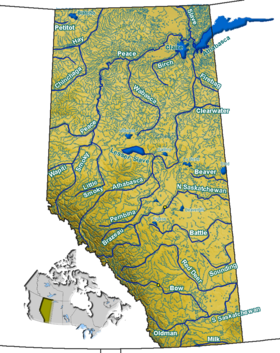
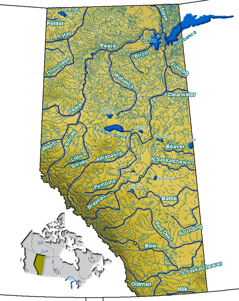
Chinchaga River in Alberta Chinchaga is a river in north-western Alberta. It is a tributary of the Hay River. Through the Hay River, its waters are carried to the Arctic Ocean via Great Slave Lake and Mackenzie River.
The name Chincaga is native, and means "Big Wood River".[1]
Contents
Course
Chinchaga River originates in the Chinchaga Lakes, a series of small lakes in the muskeg of north-eastern British Columbia, at an elevation of 795 m. It flows east into Alberta, then continues north-east until west of Keg River, where it turns north. It merges into the Hay River between Zama Lake and High Level, at an altitude of 325 m. A series of oxbow lakes are formed on the lower course. The approximate length of the river is 500 km, and the average discharge at its confluence with Hay River is 30 m³/s[2].
Tributaries
- Lennard Creek
- Tanghe Creek
- Werniuck Creek
- Sloat Creek
- Vader Creek
- Thordarson Creek
- Waniandy Creek
- Haro River
- Haig River
Conservation and development
Chinchaga Wildland Park is a large tract of land set aside by the Alberta Government for protection of the habitat of grizzly bears and woodland caribou, as well as nesting sites of trumpeter swan.[3] However, the rest of the Chinchaga area is a well known hunting ground.[4] Significant oil and gas fields (such as Hamburg) and logging are developed in the area.
See also
- Geography of Alberta
- List of Alberta rivers
References
- ^ Land Surveyors in Alberta. "Place Names". http://www.landsurveyinghistory.ab.ca/PlaceNames/Cabin_Lake-Cyclamen_Ridge.htm. Retrieved -2009-03-17.
- ^ Alberta Environment - Alberta River Basins; Chinchaga Discharge Graph
- ^ Alberta Community Development - Chinchaga Wildland Park
- ^ Chinchaga River hunting
Hydrography of Alberta Rivers 
Waterfalls Lakes Reservoirs Glaciers Other - Peace–Athabasca Delta
Coordinates: 58°52′19″N 118°18′50″W / 58.87194°N 118.31389°W
Categories:- Rivers of Alberta
- Alberta geography stubs
Wikimedia Foundation. 2010.