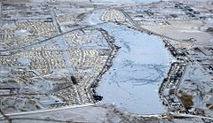
- Chestermere Lake
-
Chestermere Lake in winter Location Chestermere, Alberta Coordinates 51°02′20″N 113°49′07″W / 51.03889°N 113.81861°WCoordinates: 51°02′20″N 113°49′07″W / 51.03889°N 113.81861°W Lake type reservoir Basin countries Canada Max. length 5 km (3.1 mi) Max. width 0.7 km (0.43 mi) Surface area 2.65 km2 (1.02 sq mi) Max. depth 7 m (23 ft) Surface elevation 1,028 m (3,373 ft) Chestermere Lake is a man-made reservoir in Chestermere, Alberta, Canada.
It was built in the 1880's by the Canadian Pacific Railway, for irrigation of the area between Calgary and Strathmore. It is presently used mainly for recreation purposes, such as swimming, windsurfing, fishing and skating (in winter). The town of Chestermere surrounds the lake on three sides. The Trans-Canada Highway follows the northeastern shore, while the railway tracks pass by the southern shore.
The lake covers a surface of 2.65 square kilometres and has a maximum depth of 7 metres.[1] It drains into two irrigation canals and is filled via a canal from the Bow River.
The phrase "Chestermere Lake" is actually inaccurate as "mere" means lake in English. With "Chester" an English word derived from the Latin for a defensive fort and meaning "Castle", this would make "Chestermere Lake" translate as "Lake Castle Lake".
References
- ^ Atlas of Alberta Lakes - Chestermere Lake
Hydrography of Alberta Rivers Waterfalls Lakes Reservoirs - Abraham
- Barrier
- Brazeau
- Chestermere
- Kananaskis
- McGregor
- Minnewanka
- Glenmore
- Milk River Ridge
- Sikome
Glaciers Other - Peace–Athabasca Delta
Categories:- Lakes of Alberta
- Reservoirs in Canada
- Rocky View County, Alberta
- Calgary Region geography stubs
Wikimedia Foundation. 2010.


